![]()
ENG:Cerro Bustamante

| |


|
|
|
| |||||||||||||||||||||||||||||||||||||||||||||||||||


General description

Zero Bustamante is part of the mountain range of the coast, and rises 1874 m above sea level. To the east is the village El Noviciado and to the southeast the Mina de lo Aguirre. Cerro Bustamante is a good option for winter climbs. From the summit you get a good panoramic view of the Central Andes.
Appropriate time
It is recommended all year round, but especially in winter, when the higher altitudes have too much snow and this mountain is greener. Ideally, early September.
Access
Go along Route 68 and park just before the Lo Prado tunnel.
In public transport and hitchhiking
It is very easy to ascend this mountain with public transport. You must arrive by subway to Pajaritos station on line 1 (red line). Once there, walk to the bus terminal located in the same Pajaritos station, and take a bus to Curacaví, which depart with high frequency. You must get off just before the Lo Prado tunnel, but you will have to pay full fare.
Alternative access for The Novitiate
Through this town is where we find the road that goes in the direction of Cerro Bustamante. At the end of Noviciado there is a wooden gate, where you have to ask permission from the owner of the farm. Once inside the enclosure, advance along a path that goes through a ravine. At the end of the road, you have to make your way through the thick vegetation, since there are no trails. Enter a little more and take height to climb the east edge, which then gives way to a ridge that runs from east to west and ends at the top of Cerro Bustamante.
Description of the route

From the south side of the tunnel (542m) Climb the south side of the road and enter through a dump to a quite marked zigzag footprint, called Slope del Zorro. You get to the antennas (1060m), located above the tunnel. Then it gradually begins to gain altitude, first with South orientation, turning north and then passing a pass that takes us to the top of the tunnel from where we can see Curacaví. From that point, the climb is a little more pronounced, but never as to exhibit, and goes into a forest of boldos and litres. To our right we will observe the Nuclear Center of Lo Aguirre. Near the summit we will find the remains of the Canadian Cessna 180 C-FTQT plane that crashed there in November 2006. Passing the summit and following the path to the East we will find the road to Noviciado where you can take the bus back. If you go down to the West, you will arrive at Mauco, which is a sector of plots of pleasure from where you can get to Curacaví.
Expected time
At a normal walking pace, this trekking should take between 4 and 5 hours.
Permits / Rates
 |
Esta ruta es gratis y no se requiere permiso |
|---|
Photo Gallery
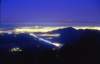
View of Santiago at nightfall from the Cerro Bustamante
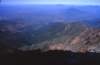
View towards the South
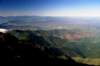
Vista Sur
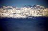
El Cerro el Plomo next to La Paloma and the Altar


Recommendations
- Checklist: Aunque sepas perfectamente lo que debes llevar, es preferible chequearlo al empacar. Esta ruta ha sido clasificada como Type 1 equipment checklist: low altitude route, without camping, snow or cold.
- Water is very important.
- Bring back your trash and if you can and you find other people's garbage along the way, please also bring it, if we all cooperate we will clean the hills.
- It is not recommended to climb Cerro Bustamante in the middle of summer, because it is hot and somewhat arid.
External Links
Weather forecast
- Meteochile Region of Valparaíso
- Accuweather Valparaíso
- Accuweather Viña del Mar
- Meteochile Metropolitan Region
- Accuweather Santiago
- Accuweather Puente Alto
Revisa la lista completa de 622 rutas de trekking y las 345 rutas de montaña en Chile
|