![]()
Diferencia entre revisiones de «Volcán Antuco - Trapa Trapa»
| Línea 5: | Línea 5: | ||
|Actividad=Trekking | |Actividad=Trekking | ||
|País=Chile | |País=Chile | ||
| − | |CiudadesChile= | + | |CiudadesChile=Los Ángeles |
|BellezaEscenica=Impresionante | |BellezaEscenica=Impresionante | ||
|Atractivos=Vistas panorámicas, Bosque, Fuente Termal, Laguna, Río, Formación Geológica, Parque Nacional | |Atractivos=Vistas panorámicas, Bosque, Fuente Termal, Laguna, Río, Formación Geológica, Parque Nacional | ||
| Línea 20: | Línea 20: | ||
|Primer Autor=Jan Dudeck | |Primer Autor=Jan Dudeck | ||
|Tipo de Extensión Imagen=jpg | |Tipo de Extensión Imagen=jpg | ||
| − | |KMLZ= | + | |KMLZ= |
|ComentariosMapa= | |ComentariosMapa= | ||
<span style="background-color:#808080; color:RED">'''Red:'''</span> Section 1, 3, 5, 7, 9: Regular Trekking Trail (No packraft required) <br> | <span style="background-color:#808080; color:RED">'''Red:'''</span> Section 1, 3, 5, 7, 9: Regular Trekking Trail (No packraft required) <br> | ||
Revisión del 16:26 8 feb 2015

|
| ||||||||||||||||||||||||||||||||||||||||||||||
Greater Patagonian Trail - Section 4: Volcán Antuco
Summary
Route Description
- Duration: x to x days
- Distance: x km
- Ascent: x meters ↑
- Descent: x meters ↓
Images
Recommended Season
Difficulty
The isolation and the high passes make this a rather difficult but rewarding trail. Good orientational skill are required because hardly any signposts are placed and some parts of the trail are cross country.
Expected Duration
Recommended Season
Trekking Direction
Permits and Entrance Fees
Inhabitation and Tourism
Food Supply
Water Supply
Maps
The electronic map Topo Chile Deluxe from Garmin shows the contours precisely but some lakes and smaller river are incorrect displayed. Only few trail sections are integrated. Some of the “Alleys” of this electronic map are far off the true position or inexistent. You should use the Greater Patagonian Trail data files for navigation.
Difficulty
Access to Start
Return from Finish
Suggested Stages
| Stage | Days | Stage End Point | Stage End Waypoint | Distance | Ascent ↑ | Descent ↓ | Time |
|---|---|---|---|---|---|---|---|
| A | 1 | (Start to) El Boslon | Refuge (GPT01-WP011) | 20 km | 1180 m | 140 m | 06:10 |
| B | 1 | Laguna Mondaca | Camp (GPT01-WP016) | 16 km | 1000 m | 1210 m | 05:20 |
Stage A: Start to El Bolson
If you leave in the morning in Radal you can reach in one day the camp and refuge El Bolson. Parque Ingles is a good place for a lunch break.
Stage B: El Boslon to Laguna Mondaca
From El Bolson you get in one day to the Laguna Mondaca. If you partition this stage differently be aware that there are no inviting camp sites between the Laguna las Ánimas and the Laguna Mondaca. This stage should not be attempted in bad weather.
Waypoints
| Waypoint Name and Waypoint Code | Comment |
|---|---|
| Start (GPT01-WP001) | Start in Radal at final bus stop. Only in January and February some busses continue to Parque Ingles. |
| Shop (GPT01-WP002) | Small shop with basic supplies in Radal. Good to get a beer and some extra goodies for the night but not to supply you for the trip. |
Tracks
| Track Name | Comment |
|---|---|
| GPT01-TR001-2 | Take the public gravel road from Radal to Parque Ingles. Only few vehicles use this road but traffic increases in January and February. |
| GPT01-TR002-1 | The track starts left at the entrance of Parque Ingles. The national park trail from Radal to El Bolson is well main-tained and clearly visible with some signposts and marks. After El Bolson the trail occasionally splits and peters out so try to follow the GPS trek when in doubt until reaching the 2560 m high pass. At the pass do not descent the well visible trail that keeps right but follow the GPS trek that descents directly towards the Laguna Mondaca. During the descent the trail is partially only vaguely visible.
Option 2: If you took the short way to the Route 115 and you still want to complete the entire trail than you need to walk 9 km on the paved Route 115. Not recommended! |
Next Sections
| Next Section | Comment |
|---|---|
| Northern | Section 3: Volcán Chillan |
| Southern | Section 5: Laguna El Barco |
Image Gallery
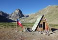
El Bolsón
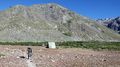
Leaving El Bolsón

