Diferencia entre revisiones de «Glaciar del Juncal (english)»
(→Permits) |
|||
| (No se muestran 15 ediciones intermedias de 3 usuarios) | |||
| Línea 5: | Línea 5: | ||
|style="width:1000px" valign="top" |{{Trekking Chile}} | |style="width:1000px" valign="top" |{{Trekking Chile}} | ||
{{Mountain Bike Chile}} | {{Mountain Bike Chile}} | ||
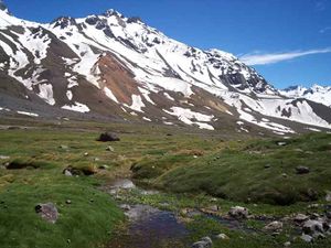
| − | [[Imagen:Vista Glaciar del Juncal.jpg|thumb | + | [[Imagen:Vista Glaciar del Juncal.jpg|thumb|View of the Juncal Glacier]] |
|} | |} | ||
{{Linea divisoria invisible}} | {{Linea divisoria invisible}} | ||
==Season== | ==Season== | ||
| − | '''Trekking | + | '''Trekking''': September-May. Although the valley is high, its orientation does not allow for the accumulation of snow, making it a bad destination for randonnée. |
==Access== | ==Access== | ||
===Vehicle Access=== | ===Vehicle Access=== | ||
| − | [[Imagen:Mapa de acceso al trek Glaciar del Juncal.jpg|thumb | + | [[Imagen:Mapa de acceso al trek Glaciar del Juncal.jpg|thumb|Map of Access to the Juncal Glacier. Imagen: [http://www.vialidad.cl Dirección de Vialidad] ]] |
| − | From Los Andes, you should take the international road to Mendoza CH-60. Continue | + | From Los Andes, you should take the international road to Mendoza CH-60. Continue up this road, past Rio Blanco and Guardia Vieja, and 3 snow "tunnels", for a total of approximately 50 km and exit to the right, immediately before the start of a series of steep curves that leads to Portillo. Once off the main road, take a turn left and then right again around a goat herders house and up and along a dirt road. You will always have the río Juncal to your right and the remnants of the Transandine Railway that linked Los Andes to Mendoza until the early '80s. After 3 kms you will reach a old rather decrepit stone "pirca" or wall, the entrance to the Parque Andino Juncal, a private protected area that belongs to the Kenrick Lyon family. The Parque was designated a Ramsar site in 2010, because of the international importance of its wetlands. It is Chile's 12th Ramsar site. The state of the dirt road will depend on the time of the year, the rain and snowfall. After 6 kms you will reach Los Hornitos where vehicles can be left. There are two old mining constructions, one of which houses the Park Ranger and a mining processing plant ruin, the Hotel Mil Estrellas, where we suggest you camp, protected from the wind and close to a simple but functional public bathroom. You must register with the Park Ranger before starting your trek. |
| − | + | ||
===Access by Public Transportation=== | ===Access by Public Transportation=== | ||
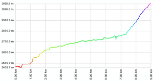
| − | [[Imagen:Perfil_Glaciar_Juncal.png|thumb | + | [[Imagen:Perfil_Glaciar_Juncal.png|thumb|left|Perfil de alturas del trekking. The vertical scale is increased]] |
| − | #You can take a bus in Santiago (at Los Heroes subway terminal) that goes to Mendoza. | + | #You can take a bus in Santiago (at Los Heroes subway terminal) that goes to Mendoza. You have to pay the price of the total trip and negotiate a special price, since you will not be going to Mendoza. Ask to be left at Curva Cero (Curve Cero), or at the Galpon de Vialidad Juncal. From there, the walk is about 2 hours long. |
| − | #From Los Andes, take a "colectivo" to Rio Blanco. | + | #From Los Andes, take a "colectivo" to Rio Blanco. Ask to be taken either to Curva Cero or Los Hornitos. Walk for about 2 hours. |
| − | #From Los Andes take a bus to Rio Blanco. | + | #From Los Andes take a bus to Rio Blanco. Hitchhike to the gas station to curve cero. Walk for 2 hours. |
==Route Description== | ==Route Description== | ||
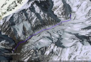
[[Imagen:Trek_Glaciar_Juncal_ruta.jpg|left|thumb|Juncal Glacier Trek, Google Earth Image]] | [[Imagen:Trek_Glaciar_Juncal_ruta.jpg|left|thumb|Juncal Glacier Trek, Google Earth Image]] | ||
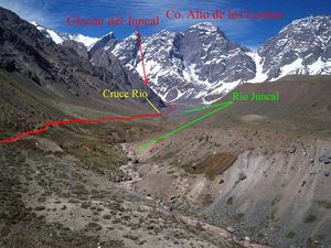
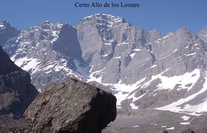
| − | After parking | + | After parking in Los Hornitos, and registering and paying your entrance fee with the Park Ranger, start walking along the trail towards the southeast, after about 5 minutes you will reach a bridge that crosses the river. The trail slowly ascends for about 25 minutes reaching a lookout that reveals the the entire valley and the beauty of the Nevados de Juncal and the Alto de Los Leones. The path descends gently until reaching the Vegas de Nacimiento wetlands, starting here, the walk is relatively flat with a few occasional ascents and descents. Immediately after passing the Vegas de Nacimiento (very delicate, please refrain from walking on them, particularly as a result of the drought and illegal cattle grazing), you will reach an area of morains that is called the Las Morrenas campsite. Here the trail will fork out into different paths, you should keep going south-south-east until reaching the Estero Monos de Agua, this stream is approx. 7 mts wide but during the late summer months when the glacier thaws it can be the greatest obstacle of the entire trek. To cross the Estero, it is recommended to take sandals and a small towel (the water is freezing cold), and a rope. [[Imagen:Ruta Glaciar del Juncal.jpg|thumb|Route to Juncal Glacier]]. It is also recommended crossing the Estero Monos de Agua as early as possible in the day to avoid the increase in the volume of water (but if visiting for the day, bear in mind that water volume will increase towards the evening). The periods of greatest flow are between the months of December and early February, and between 1300 and 1600 hours. Once having crossed, continue south along the valley of the Juncal river (the same valley you have been walking up the trail), and not the Monos de Agua Valley, the later would take you to the [[Glaciar Francisco Moreno]] described under the trek with the same name. Fifteen minutes from the river the trail begins to ascend and after going around a hill the trail turns [[Imagen:Vista Cerro Alto de los Leones.jpg|left|thumb|View of the Alto de Los Leones Peak]] left gradually revealing the Glaciar Juncal. The morraines of the glacier will begin to appear as the trail disappears. Here a decision must be taken as to how far to continue. You should bear in mind that when you reach the moraine you will be standing on the glacier, and these tend to have large [[Imagen:Paisaje trek Glaciar del Juncal.jpg|thumb|Landscape Juncal Glacier Trek]]potentially dangerous crevasses that could be hidden from sight under the snow. Walk until established viewing point. |
| − | + | ||
===Estimated Time=== | ===Estimated Time=== | ||
*'''Trekking''': 4 hours to the the glacier and 3 hours back. | *'''Trekking''': 4 hours to the the glacier and 3 hours back. | ||
| − | + | Also consider the 30 minutes car ride from the start of the dirt road to the beginning of the trek. | |
| − | Also consider 30 minutes | + | |
==Permits== | ==Permits== | ||
| − | + | The Parque Andino Juncal is located on a private property belonging to the Comunidad Kenrick Lyon. Entrance fee is $5.000 CLP per person per day. Camping is $2.500 CLP per person per day. There is one public bathroom in Los Hornitos, and rudimentary signage. For more information go to [http://www.parqueandinojuncal.org Parque Andino Juncal] or the Facebook site at https://www.facebook.com/Parqueandinojuncal/. | |
| − | Leave | + | Visitors are expected practice Leave No Trace principles. |
| − | + | For questions and concerns, or to reserve a cabaña, or to come with a tour group please write to: info@parqueandinojuncal.cl | |
| − | + | ||
| − | + | ||
| − | + | ||
| − | |||
==Ascending the Juncal== | ==Ascending the Juncal== | ||
Revisión actual del 13:47 5 feb 2019
| <googlemap version="0.9" lat="-32.948174" lon="-70.104202" zoom="13" width="400" height="600" type="satellite">
http://www.wikiexplora.com/kml/Glaciar_del_Juncal.kml</googlemap> |
|
Season
Trekking: September-May. Although the valley is high, its orientation does not allow for the accumulation of snow, making it a bad destination for randonnée.
Access
Vehicle Access
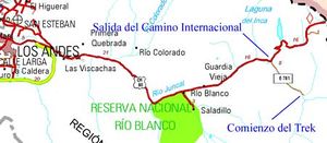
From Los Andes, you should take the international road to Mendoza CH-60. Continue up this road, past Rio Blanco and Guardia Vieja, and 3 snow "tunnels", for a total of approximately 50 km and exit to the right, immediately before the start of a series of steep curves that leads to Portillo. Once off the main road, take a turn left and then right again around a goat herders house and up and along a dirt road. You will always have the río Juncal to your right and the remnants of the Transandine Railway that linked Los Andes to Mendoza until the early '80s. After 3 kms you will reach a old rather decrepit stone "pirca" or wall, the entrance to the Parque Andino Juncal, a private protected area that belongs to the Kenrick Lyon family. The Parque was designated a Ramsar site in 2010, because of the international importance of its wetlands. It is Chile's 12th Ramsar site. The state of the dirt road will depend on the time of the year, the rain and snowfall. After 6 kms you will reach Los Hornitos where vehicles can be left. There are two old mining constructions, one of which houses the Park Ranger and a mining processing plant ruin, the Hotel Mil Estrellas, where we suggest you camp, protected from the wind and close to a simple but functional public bathroom. You must register with the Park Ranger before starting your trek.
Access by Public Transportation
- You can take a bus in Santiago (at Los Heroes subway terminal) that goes to Mendoza. You have to pay the price of the total trip and negotiate a special price, since you will not be going to Mendoza. Ask to be left at Curva Cero (Curve Cero), or at the Galpon de Vialidad Juncal. From there, the walk is about 2 hours long.
- From Los Andes, take a "colectivo" to Rio Blanco. Ask to be taken either to Curva Cero or Los Hornitos. Walk for about 2 hours.
- From Los Andes take a bus to Rio Blanco. Hitchhike to the gas station to curve cero. Walk for 2 hours.
Route Description
After parking in Los Hornitos, and registering and paying your entrance fee with the Park Ranger, start walking along the trail towards the southeast, after about 5 minutes you will reach a bridge that crosses the river. The trail slowly ascends for about 25 minutes reaching a lookout that reveals the the entire valley and the beauty of the Nevados de Juncal and the Alto de Los Leones. The path descends gently until reaching the Vegas de Nacimiento wetlands, starting here, the walk is relatively flat with a few occasional ascents and descents. Immediately after passing the Vegas de Nacimiento (very delicate, please refrain from walking on them, particularly as a result of the drought and illegal cattle grazing), you will reach an area of morains that is called the Las Morrenas campsite. Here the trail will fork out into different paths, you should keep going south-south-east until reaching the Estero Monos de Agua, this stream is approx. 7 mts wide but during the late summer months when the glacier thaws it can be the greatest obstacle of the entire trek. To cross the Estero, it is recommended to take sandals and a small towel (the water is freezing cold), and a rope. . It is also recommended crossing the Estero Monos de Agua as early as possible in the day to avoid the increase in the volume of water (but if visiting for the day, bear in mind that water volume will increase towards the evening). The periods of greatest flow are between the months of December and early February, and between 1300 and 1600 hours. Once having crossed, continue south along the valley of the Juncal river (the same valley you have been walking up the trail), and not the Monos de Agua Valley, the later would take you to the Glaciar Francisco Moreno described under the trek with the same name. Fifteen minutes from the river the trail begins to ascend and after going around a hill the trail turns left gradually revealing the Glaciar Juncal. The morraines of the glacier will begin to appear as the trail disappears. Here a decision must be taken as to how far to continue. You should bear in mind that when you reach the moraine you will be standing on the glacier, and these tend to have large potentially dangerous crevasses that could be hidden from sight under the snow. Walk until established viewing point.Estimated Time
- Trekking: 4 hours to the the glacier and 3 hours back.
Also consider the 30 minutes car ride from the start of the dirt road to the beginning of the trek.
Permits
The Parque Andino Juncal is located on a private property belonging to the Comunidad Kenrick Lyon. Entrance fee is $5.000 CLP per person per day. Camping is $2.500 CLP per person per day. There is one public bathroom in Los Hornitos, and rudimentary signage. For more information go to Parque Andino Juncal or the Facebook site at https://www.facebook.com/Parqueandinojuncal/.
Visitors are expected practice Leave No Trace principles.
For questions and concerns, or to reserve a cabaña, or to come with a tour group please write to: info@parqueandinojuncal.cl
Ascending the Juncal
- To make an ascent of the Juncal (6.110m. IGM) yo may visit descripción de la ruta en Andeshandbook.
Waypoints on Google Earth and Map Source
To download the file right-click and then select "Save file as" (IE) or "Save link as" (Firefox, Chrome). By trying to open it directly, some browsers will show the raw code with the coordinates.
Hiring Guides
Hiring guides is possible for this trek:
Montaña Nativa: Tailored tours, 2 day treks, hot springs, Glaciers, ascents and road trips. Experienced guide with a degree from Escuela Nacional de Andinismo Chileno and ornithology. Ethical and ecological vision. TripAdvisor certificate of excellence 2015.- Contact: guia@montananativa.com
- Phone: +569 6477 8461
- Social Media: Facebook Montaña Nativa
- Ecotrekking Santiago de Chile Ecotourism and "High Mountain" activities in Cajón del Maipo and Farellones. Logistics, guides, and passenger transport.
- Contact: ecotrekkingchile@gmail.com
- Facebook: Ecotrekking Santiago de Chile
- TripAdvisor: Ecotrekking Chile
- Phone: +56966028918 (WhatsApp)
- Ecochile Travel: Regular and private trekking trips in the Andes.
- Contact: info@ecochile.travel, (56- 02) 25708826
- Flecha Extrema: Private Hiking Tours / "High Mountain" Expeditions around Santiago - Experience the Andes
- Contact: contacto@flechaextrema.com, +56 9 65 61 72 77
- Facebook Turismo Flecha Extrema
- Phone: +56965617277 (Whatsapp)
- AndesBrown: Hikes and excursions in Chile's central mountains. Guided tours, certified guides
- Phone +56988382014.
- Cajonoutdoor: Treking, horse back, and excursions in all of Cajón del Maipo. Passenger transport to and from the hotel/airport/chosen destiny. Bilingual local guides.
- Contact: contacto@cajonoutdoor.cl
- Phone: +56991940429 - +56975275503.


