![]()
Diferencia entre revisiones de «GPT07 - Laguna Dial»
(→Elevation Profile of Regular Packrafting Route) |
|||
| Línea 24: | Línea 24: | ||
{{GPT KMZ}} | {{GPT KMZ}} | ||
}} | }} | ||
| + | [[File:GPT_2_Laguna_Dial_118949889.jpg|thumb|]] | ||
| + | [[File:GPT_2_Laguna_Dial_73779722.jpg|thumb|]] | ||
| + | [[File:GPT_2_Laguna_Dial_108320977.jpg|thumb|]] | ||
| + | [[File:GPT_2_Laguna_Dial_108320982.jpg|thumb|]] | ||
| + | [[File:GPT_2_Laguna_Dial_108320989.jpg|thumb|]] | ||
| + | [[File:GPT_2_Laguna_Dial_108321002.jpg|thumb|]] | ||
| + | |||
==Section Statistics== | ==Section Statistics== | ||
==Basic statistics== | ==Basic statistics== | ||
| Línea 86: | Línea 93: | ||
==Section Length and Travel Duration== | ==Section Length and Travel Duration== | ||
==Section Attractiveness== | ==Section Attractiveness== | ||
| + | Thissection of the Greater Patagonian Trail leads in four to five hiking days through the wide open valley Melado to the crystal clear Laguna Dial. This lake was formed by a volcanic eruption that plugged the upper valley and transformed this part of the river into a long lake. | ||
| + | |||
| + | With the melting snow in spring and early summer herdsmen migrate up the valley with their animals. Occasional lush green patches intermigle with vegetation that struggles with the try soil. But the now visible life and the accompanying river Melado make a refreshing change after having crossed the death beauty of volcanic ash and lava in the week before on section 1. Don’t miss the puesto of Señora Irma, where you can eat fresh goat cheese with bread that was recently baked in the hot ash of a fire. | ||
| + | |||
| + | After having passed the deep blue Laguna Dial you descent through the now tighter but equally scenic valleys of the rivers Rió Rodriguez and Los Sauces to the small settlement Pichi Rincon and a place called El Ingles. Here you can take a bus to the small town San Fabian to take a rest and to resupply. | ||
==Section Difficulty== | ==Section Difficulty== | ||
==Resupply== | ==Resupply== | ||
| Línea 105: | Línea 117: | ||
==Investigation and Exploration Tasks== | ==Investigation and Exploration Tasks== | ||
==Images== | ==Images== | ||
| + | |||
| + | <gallery> | ||
| + | File:Laguna Dial, Greater Patagonian Trail 01.jpg| | ||
| + | File:Laguna Dial, Greater Patagonian Trail 02.jpg| | ||
| + | File:Laguna Dial, Greater Patagonian Trail 03.jpg| | ||
| + | File:Laguna Dial, Greater Patagonian Trail 04.PNG| | ||
| + | File:Laguna Dial, Greater Patagonian Trail 05.jpg| | ||
| + | File:Laguna Dial, Greater Patagonian Trail 06 Puesto.PNG| | ||
| + | File:Laguna Dial, Greater Patagonian Trail 06.jpg| | ||
| + | File:Laguna Dial, Greater Patagonian Trail 07.jpg| | ||
| + | File:Laguna Dial, Greater Patagonian Trail 08.jpg| | ||
| + | File:Laguna Dial, Greater Patagonian Trail 09.jpg| | ||
| + | File:Laguna Dial, Greater Patagonian Trail 10.jpg| | ||
| + | File:Laguna Dial, Greater Patagonian Trail 11.jpg| | ||
| + | File:Laguna Dial, Greater Patagonian Trail 12.PNG|Laguna Dial | ||
| + | File:Laguna Dial, Greater Patagonian Trail 13 Laguna Dial.PNG|Laguna Dial | ||
| + | File:Laguna Dial, Greater Patagonian Trail 14 Laguna Dial 2.PNG|Laguna Dial | ||
| + | File:Laguna Dial, Greater Patagonian Trail 15.jpg| | ||
| + | File:Laguna Dial, Greater Patagonian Trail 16.PNG| | ||
| + | File:Laguna Dial, Greater Patagonian Trail 17.jpg| | ||
| + | File:Laguna Dial, Greater Patagonian Trail 18.PNG| | ||
| + | File:Laguna Dial, Greater Patagonian Trail 19.jpg| | ||
| + | File:Laguna Dial, Greater Patagonian Trail 20.jpg| | ||
| + | File:Laguna Dial, Greater Patagonian Trail 21.jpg| | ||
| + | File:Laguna Dial, Greater Patagonian Trail 22.PNG| | ||
| + | File:Laguna Dial, Greater Patagonian Trail 23.PNG| | ||
| + | File:Laguna Dial, Greater Patagonian Trail 25.PNG| | ||
| + | File:Laguna Dial, Greater Patagonian Trail 26.PNG| | ||
| + | File:Laguna Dial, Greater Patagonian Trail 27.jpg| | ||
| + | File:Laguna Dial, Greater Patagonian Trail 28.jpg| | ||
| + | File:GPT_2_Laguna_Dial_108321024.jpg| | ||
| + | File:GPT_2_Laguna_Dial_108321027.jpg| | ||
| + | File:GPT_2_Laguna_Dial_118949851.jpg| | ||
| + | File:GPT_2_Laguna_Dial_118949853.jpg| | ||
| + | </gallery> | ||
==Related Routes on Wikiexplora== | ==Related Routes on Wikiexplora== | ||
==Related Blogs and Online Publications== | ==Related Blogs and Online Publications== | ||
[[category:Greater Patagonian Trail]] | [[category:Greater Patagonian Trail]] | ||
Revisión del 11:55 28 mar 2019

|
| ||||||||||||||||||||||||||||||||||||||||||||||||||||||||


Section Statistics
Basic statistics
| Traversable | Jan - Mar (Conditionally: Dec, Apr) | |
| Packraft | Deployable (9.0 km | 9.0 % on Water) | |
| Hiking | Packrafting | |
| Attraction | 4 / 5 | No Rating |
| Difficulty | 3 / 5 | No Rating |
| Distance | 155.2 km | 50 h | 153.0 km | 48 h |
| Direction | Both ↓↑ | Both ↓↑ |
| Comment | - | |
| Status | Published and Verified | |
| Zone | B: Zona Arrieros | |
| Region | Chile: Maule (VII) & Bío Bío (VIII) | |
| Start | La Mina, Termas del Médano | |
| Finish | Puente Ingles , (El Roble) | |
| Previous Section | Next Section | Alternative Section |
| GPT06 | GPT08 | No |
Section Planning Status
Recommended Travel Period
Benefits of Hiking and Packrafting
Recommended Travel Direction
Section Length and Travel Duration
Section Attractiveness
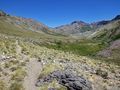
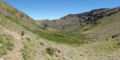
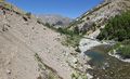
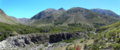
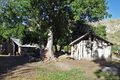
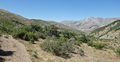
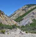
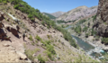
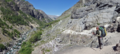
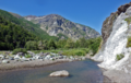
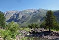
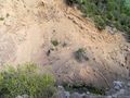
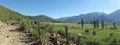
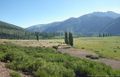
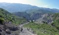
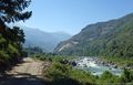
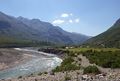
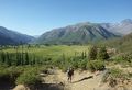
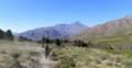
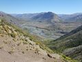
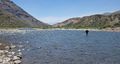
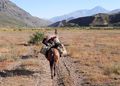
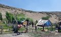
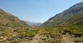
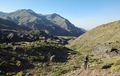
Thissection of the Greater Patagonian Trail leads in four to five hiking days through the wide open valley Melado to the crystal clear Laguna Dial. This lake was formed by a volcanic eruption that plugged the upper valley and transformed this part of the river into a long lake.
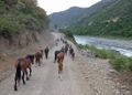
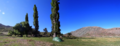
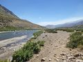
With the melting snow in spring and early summer herdsmen migrate up the valley with their animals. Occasional lush green patches intermigle with vegetation that struggles with the try soil. But the now visible life and the accompanying river Melado make a refreshing change after having crossed the death beauty of volcanic ash and lava in the week before on section 1. Don’t miss the puesto of Señora Irma, where you can eat fresh goat cheese with bread that was recently baked in the hot ash of a fire.
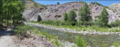
After having passed the deep blue Laguna Dial you descent through the now tighter but equally scenic valleys of the rivers Rió Rodriguez and Los Sauces to the small settlement Pichi Rincon and a place called El Ingles. Here you can take a bus to the small town San Fabian to take a rest and to resupply.
Section Difficulty
Resupply
Resupply Towns at Start, Finish and off Route
Resupply en Route
Access to Route
Permits, Entry Fees, Right-of-Way Issues
Regular Route
Regular Hiking Route
Elevation Profile of Regular Hiking Route

Comments to Regular Hiking Route
Regular Packrafting Route
Elevation Profile of Regular Packrafting Route

Comments to Regular Packrafting Route
Optional Routes
Investigation and Exploration Tasks
Images
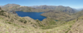
Laguna Dial
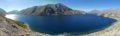
Laguna Dial
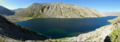
Laguna Dial