![]()
Diferencia entre revisiones de «ENG:Dientes de Navarino»
(→Season) |
(→Recommendations) |
||
| (No se muestran 37 ediciones intermedias de 4 usuarios) | |||
| Línea 1: | Línea 1: | ||
| − | + | [[ES:Dientes de Navarino]] | |
| − | {{ | + | {{Indexed}} |
{{Rutas Patrimoniales english}} | {{Rutas Patrimoniales english}} | ||
| + | |||
| + | {{RutaForme | ||
| + | |Actividad=Trekking | ||
| + | |||
| + | |País=Chile (english) | ||
| + | |CiudadesChile=Puerto Williams | ||
| + | |BellezaEscenica=Impresionante | ||
| + | |Atractivos=Vistas panorámicas, Bosque, Lago, Río, Mar, Isla | ||
| + | |Duracion=5 días | ||
| + | Algo Exigente | ||
| + | |||
| + | |Sendero=Tramos sin sendero | ||
| + | |Señalizacion=Insuficiente | ||
| + | |Infraestructura=Inexistente | ||
| + | |||
| + | |ComparteIdayRetorno=Cruce | ||
| + | |Distancia=0 | ||
| + | |||
| + | |MetrosAscenso= | ||
| + | |MetrosDescenso= | ||
| + | |Comentarios distancia= | ||
| + | |AltitudMedia= | ||
| + | |Primer Autor=Ministerio de Bienes Nacionales | ||
| + | |Imágen Principal=DDN dia 4.jpg | ||
| + | |ComentariosImagen=Farellones rocosos en el macizo de los Dientes de Navarino | ||
| + | |m=https://www.google.com/maps/d/u/0/embed?mid=1pwwHs47fZDUwlrKNafZRQ0j9O2WkmHjv | ||
| + | |KMLZ=Dientes de Navarino.kmz | ||
| + | |ComentariosMapa= {{aportar track}} | ||
| + | |TipoDeMap=HYBRID | ||
| + | }} | ||
| + | |||
| + | |||
| + | {{Linea divisoria invisible}} | ||
| + | |||
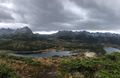
| + | [[File:Panoramica DDN.jpg|center|800px]] | ||
| + | |||
| + | {{Linea divisoria invisible}} | ||
| + | |||
==Season== | ==Season== | ||
| + | [[File:Trekking-dientes-de-navarino.jpg|thumb|Trekking Dientes de Navarino]] | ||
| + | |||
November to late march. During winter, conditions can be very harsh and daylight short. | November to late march. During winter, conditions can be very harsh and daylight short. | ||
{{Access Puerto Williams}} | {{Access Puerto Williams}} | ||
| + | |||
| + | ==Signaling== | ||
| + | [[File:Senaletica_DdeN.jpg|thumb|right]] | ||
| + | |||
| + | The trailmarker design copies | ||
| + | the French marker system for | ||
| + | trekkers, which has been a pioneer | ||
| + | in its field and recognized | ||
| + | worldwide for its efficiency and | ||
| + | simplicity. Four classes of | ||
| + | trailmarkers were adopted from this | ||
| + | system:<br> | ||
| + | |||
| + | Likewise, the French system has | ||
| + | been complemented by a series of | ||
| + | numbers inscribed along with some of | ||
| + | the painted markers throughout the trail. | ||
| + | In this sense, out of a total of 395 | ||
| + | markers, 38 (known as GUIDEPOST, | ||
| + | abbreviated form of Numerical System | ||
| + | for Points of Special Interest) have been | ||
| + | singled out.<br> | ||
| + | |||
| + | GUIDEPOSTs are Arabic numbers | ||
| + | that periodically accompany the | ||
| + | regular route and direction markers; | ||
| + | each has its own meaning, which is | ||
| + | explained in the topoguide. Chapter | ||
| + | Two provides an orderly listing of | ||
| + | the GUIDEPOSTs according to the | ||
| + | 5 trail segments that describe in both | ||
| + | written and photographic form, | ||
| + | among other aspects, the heading | ||
| + | to follow, trip duration, camping | ||
| + | spots, dangerous locations, | ||
| + | geographical names (toponymy), | ||
| + | and the trail's general features.<br> | ||
| + | |||
| + | '''Trailmarking direction:''' Trailmarking is unidirectional, | ||
| + | with the starting point in the vicinity | ||
| + | of the waterfall ([[Hitos_Dientes_de_Navarino#Hito_1|GUIDEPOST nº1]]), | ||
| + | and the end near Virginia Bay, by | ||
| + | the MacLean fish company | ||
| + | ([[Hitos_Dientes_de_Navarino#Hito_38|GUIDEPOST nº38]]). It is possible | ||
| + | to travel the route backwards, | ||
| + | following the topoguide's | ||
| + | description and pictures from end | ||
| + | to beginning, but be warned, in | ||
| + | doing so, you will find yourself | ||
| + | faced with two very steep slopes | ||
| + | that are easier to go down than up.<br> | ||
| + | |||
| + | '''Earlier markers''': In the forest near the waterfall | ||
| + | (segment 1 of the trail), you will | ||
| + | find old markings on the trees. The | ||
| + | markings are so unaesthetic, | ||
| + | anarchic, and erratic that they end | ||
| + | up confusing the hiker. So, an | ||
| + | absolute minimum number of | ||
| + | markers were placed in order to not | ||
| + | continue overloading the forest with | ||
| + | signs. If you have any trouble | ||
| + | following our markers, turn to the | ||
| + | topoguide for indications and to the | ||
| + | layout of the path on the ground.<br> | ||
==Route description== | ==Route description== | ||
| − | === | + | |
| + | ===Segment 1=== | ||
| + | '''Puerto Williams - Laguna del Salto''' | ||
| + | |||
| + | [[Imagen:Desnivel DDN 1.jpg|thumb|left]] | ||
| + | |||
| + | [[Imagen:64- cerro bandera.JPG |thumb|left|Puerto Williams, Beagle Channel, Tierra del Fuego, Gable Island from 300 msnm. File: Juan Fco. Bustos]] | ||
| + | |||
| + | [[Imagen:Trekking-dientes-de-navarino-2.jpg|thumb|left]] | ||
| + | |||
| + | [[Imagen:65- cerro bandera.JPG |thumb|The Flag, february 2009. File: Juan Fco. Bustos]] | ||
| + | |||
Puerto Williams. Leave town by the | Puerto Williams. Leave town by the | ||
road heading west. After about 1 | road heading west. After about 1 | ||
| Línea 17: | Línea 133: | ||
the beginning of the trail at the end of | the beginning of the trail at the end of | ||
the road, next to a waterfall and the | the road, next to a waterfall and the | ||
| − | dam. | + | dam.<br> |
| + | |||
Take the path that goes toward the | Take the path that goes toward the | ||
| − | woods indicated by GUIDEPOST N° | + | woods indicated by [[Hitos_Dientes_de_Navarino#Hito_1|GUIDEPOST N° |
| − | 1; it runs parallel to the river course, | + | 1]]; it runs parallel to the river course, |
above the bank. Don't take the path | above the bank. Don't take the path | ||
that follows the river, nor the one that | that follows the river, nor the one that | ||
goes east. Hike through the forest for | goes east. Hike through the forest for | ||
10 minutes, then the path abruptly turns | 10 minutes, then the path abruptly turns | ||
| − | east (GUIDEPOST N° 2), and goes | + | east ([[Hitos_Dientes_de_Navarino#Hito_2|GUIDEPOST N° 2]]), and goes |
toward the side of the hill. Follow it, | toward the side of the hill. Follow it, | ||
always heading towards the steep | always heading towards the steep | ||
slope. After leaving the forest | slope. After leaving the forest | ||
| − | (GUIDEPOST N° 3), stay on the path, | + | ([[Hitos_Dientes_de_Navarino#Hito_3|GUIDEPOST N° 3]]), stay on the path, |
keeping the stakes in sight, until | keeping the stakes in sight, until | ||
reaching the low peak of Cerro | reaching the low peak of Cerro | ||
Bandera (stone landmark and | Bandera (stone landmark and | ||
| − | GUIDEPOST N° 4). Be careful not | + | [[Hitos_Dientes_de_Navarino#Hito_4|GUIDEPOST N° 4]]). Be careful not |
to step on the low, dense, and hard | to step on the low, dense, and hard | ||
| − | green plant formations. | + | green plant formations.<br> |
| + | |||
Head 230° and follow the stakes. After | Head 230° and follow the stakes. After | ||
a 10-minute walk from the low peak, | a 10-minute walk from the low peak, | ||
on the right (west) you will find the | on the right (west) you will find the | ||
high peak of Cerro Bandera | high peak of Cerro Bandera | ||
| − | (GUIDEPOST N° 5). Without | + | ([[Hitos_Dientes_de_Navarino#Hito_5|GUIDEPOST N° 5]]). Without |
| − | climbing towards GUIDEPOST N°5, | + | climbing towards [[Hitos_Dientes_de_Navarino#Hito_5|GUIDEPOST N°5]], |
go 180° and follow the stone | go 180° and follow the stone | ||
landmarks, passing the next hill on the | landmarks, passing the next hill on the | ||
| Línea 48: | Línea 166: | ||
arrows drawn on the landmarks. | arrows drawn on the landmarks. | ||
Farther ahead you will find | Farther ahead you will find | ||
| − | GUIDEPOST N° 6, that marks a small | + | [[Hitos_Dientes_de_Navarino#Hito_6|GUIDEPOST N° 6]], that marks a small |
river crossing, from where you should | river crossing, from where you should | ||
bear 230° following the stone | bear 230° following the stone | ||
| Línea 55: | Línea 173: | ||
project an imaginary route that is closer | project an imaginary route that is closer | ||
to the tree line than to the ridgeline | to the tree line than to the ridgeline | ||
| − | (GUIDEPOST N° 7 and 8). | + | ([[Hitos_Dientes_de_Navarino#Hito_7|GUIDEPOST N° 7 and 8]]).<br> |
| + | |||
The foothills route will take you above | The foothills route will take you above | ||
| − | Laguna del Salto (GUIDEPOST N° 9). | + | Laguna del Salto ([[Hitos_Dientes_de_Navarino#Hito_9|GUIDEPOST N° 9]]). |
There you should turn right, and climb | There you should turn right, and climb | ||
down a steep slope toward the lagoon. | down a steep slope toward the lagoon. | ||
| Línea 65: | Línea 184: | ||
Carefully descend in the direction of a | Carefully descend in the direction of a | ||
large dark rock, on top of which you will | large dark rock, on top of which you will | ||
| − | find GUIDEPOST N° 10, located about | + | find [[Hitos_Dientes_de_Navarino#Hito_10|GUIDEPOST N° 10]], located about |
40 meters away from the Laguna del | 40 meters away from the Laguna del | ||
| − | Salto shore. End of first segment. | + | Salto shore. End of first segment.<br> |
| − | === | + | |
| + | ===Segment 2=== | ||
| + | '''Laguna del Salto - Laguna Escondida''' | ||
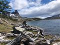
| + | [[Imagen:Desnivel DDN 2.jpg|thumb|left]] | ||
| + | [[Imagen:DDN dia 2.jpg|thumb|right]] | ||
| + | |||
Circle Laguna del Salto on the | Circle Laguna del Salto on the | ||
left (east). To the south of the lagoon, | left (east). To the south of the lagoon, | ||
| Línea 75: | Línea 199: | ||
rocks under the water. Climb before | rocks under the water. Climb before | ||
the knoll, immediately to the left of | the knoll, immediately to the left of | ||
| − | this (GUIDEPOST N° 11), following | + | this ([[Hitos_Dientes_de_Navarino#Hito_11|GUIDEPOST N° 11]]), following |
the creek closest to the rocky | the creek closest to the rocky | ||
promontory that runs by a steep-sided | promontory that runs by a steep-sided | ||
| − | gulch. | + | gulch.<br> |
| + | |||
Continue for the length of the | Continue for the length of the | ||
gulch until crossing the knoll's peak. | gulch until crossing the knoll's peak. | ||
| Línea 84: | Línea 209: | ||
natural course of a small winding | natural course of a small winding | ||
valley that extends up to a wide plain | valley that extends up to a wide plain | ||
| − | (GUIDEPOST N° 12). After crossing | + | ([[Hitos_Dientes_de_Navarino#Hito_12|GUIDEPOST N° 12]]). After crossing |
the river, climb to the right over a large | the river, climb to the right over a large | ||
hill covered with grass and peat moss | hill covered with grass and peat moss | ||
| Línea 90: | Línea 215: | ||
Follow the crest of the hill until arriving | Follow the crest of the hill until arriving | ||
at a small, rocky pass - "Paso Primero" | at a small, rocky pass - "Paso Primero" | ||
| − | - from which you descend to a creek. | + | - from which you descend to a creek.<br> |
| + | |||
After Paso Primero, follow the | After Paso Primero, follow the | ||
course of the creek until reaching the | course of the creek until reaching the | ||
entrance of the high valley | entrance of the high valley | ||
| − | (GUIDEPOST N° 13), where it is | + | ([[Hitos_Dientes_de_Navarino#Hito_13|GUIDEPOST N° 13]]), where it is |
common to find snow, even in the | common to find snow, even in the | ||
summer. Follow the valley to the left | summer. Follow the valley to the left | ||
(east), bearing 140°, until reaching | (east), bearing 140°, until reaching | ||
| − | Paso Australia (GUIDEPOST N° 14) | + | Paso Australia ([[Hitos_Dientes_de_Navarino#Hito_14|GUIDEPOST N° 14]]) |
marked by an important landmark of | marked by an important landmark of | ||
| − | stones. | + | stones.<br> |
| + | |||
Go to the right of the lagoon | Go to the right of the lagoon | ||
lying at the foot of Paso Australia | lying at the foot of Paso Australia | ||
| Línea 110: | Línea 237: | ||
slabs of snow. Project an imaginary | slabs of snow. Project an imaginary | ||
bearing while always keeping the | bearing while always keeping the | ||
| − | markers in sight. | + | markers in sight.<br> |
| + | |||
Thus, you get to Paso de los | Thus, you get to Paso de los | ||
Dientes that looks to the south | Dientes that looks to the south | ||
| − | (GUIDEPOST N° 15) Go down to | + | ([[Hitos_Dientes_de_Navarino#Hito_15|GUIDEPOST N° 15]]) Go down to |
the valley that opens up on the other | the valley that opens up on the other | ||
side of the pass, going to the left of | side of the pass, going to the left of | ||
the lagoons. On the south shore of | the lagoons. On the south shore of | ||
the third lagoon you will find | the third lagoon you will find | ||
| − | GUIDEPOST N° 16. Turn to the right, | + | [[Hitos_Dientes_de_Navarino#Hito_16|GUIDEPOST N° 16]]. Turn to the right, |
bearing 240°, continue toward | bearing 240°, continue toward | ||
Laguna de los Dientes. On the east | Laguna de los Dientes. On the east | ||
| − | shore you will find GUIDEPOST N° | + | shore you will find [[Hitos_Dientes_de_Navarino#Hito_17|GUIDEPOST N° |
| − | 17. Circle it to the north until reaching | + | 17]]. Circle it to the north until reaching |
| − | its west shore (GUIDEPOST N° 18), | + | its west shore ([[Hitos_Dientes_de_Navarino#Hito_18|GUIDEPOST N° 18]]), |
up to the point where a valley opens | up to the point where a valley opens | ||
up to the right. Follow it, bearing | up to the right. Follow it, bearing | ||
290°, until arriving at Laguna | 290°, until arriving at Laguna | ||
Escondida where you will find | Escondida where you will find | ||
| − | GUIDEPOST N° 19 on the east shore. | + | [[Hitos_Dientes_de_Navarino#Hito_19|GUIDEPOST N° 19]] on the east shore. |
End of segment. For campsites, | End of segment. For campsites, | ||
check the options offered by | check the options offered by | ||
| − | GUIDEPOSTs 16, 17, 19, and 20. | + | [[Hitos_Dientes_de_Navarino#Hito_16|GUIDEPOSTs 16, 17, 19, and 20]].<br> |
| − | === | + | |
| + | ===Segment 3=== | ||
| + | '''Laguna Escondida - Laguna Martillo''' | ||
| + | [[Imagen:Desnivel DDN 3.jpg|thumb|left]] | ||
| + | [[Imagen:DDN dia 3a.jpg|thumb|right]] | ||
| + | [[Imagen:DDN dia 3b.jpg|thumb|right]] | ||
| + | |||
| + | |||
Circle Laguna Escondida on the | Circle Laguna Escondida on the | ||
left, bearing south, and follow the | left, bearing south, and follow the | ||
river a short way. After a brief distance | river a short way. After a brief distance | ||
| − | (GUIDEPOST N° 20), enter the valley | + | ([[Hitos_Dientes_de_Navarino#Hito_20|GUIDEPOST N° 20]]), enter the valley |
that opens up to the right, bearing | that opens up to the right, bearing | ||
210°. Paso Ventarrón is in view; | 210°. Paso Ventarrón is in view; | ||
| Línea 144: | Línea 279: | ||
of the valley. On the left, at the foot | of the valley. On the left, at the foot | ||
of Paso Ventarrón you will find | of Paso Ventarrón you will find | ||
| − | GUIDEPOST N° 21. From that | + | [[Hitos_Dientes_de_Navarino#Hito_20|GUIDEPOST N° 21]]. From that |
location, you will be in front of a short, | location, you will be in front of a short, | ||
abrupt slope that leads to the pass. | abrupt slope that leads to the pass. | ||
| − | Once in the pass (GUIDEPOST N° | + | Once in the pass ([[Hitos_Dientes_de_Navarino#Hito_22|GUIDEPOST N° |
| − | 22), do not go down the other side or | + | 22]]), do not go down the other side or |
toward the foothill, continue climbing | toward the foothill, continue climbing | ||
to the right (bearing west), for | to the right (bearing west), for | ||
| Línea 154: | Línea 289: | ||
down to the valley. Go down the | down to the valley. Go down the | ||
right side of the valley to the foot | right side of the valley to the foot | ||
| − | of Paso Guerrico (GUIDEPOST | + | of Paso Guerrico ([[Hitos_Dientes_de_Navarino#Hito_23|GUIDEPOST |
| − | N° 23). | + | N° 23]]).<br> |
| + | |||
Climb up a short, steep | Climb up a short, steep | ||
hillside, bearing 230°, go through | hillside, bearing 230°, go through | ||
| Línea 161: | Línea 297: | ||
growing among large rocks, until | growing among large rocks, until | ||
reaching Paso Guerrico | reaching Paso Guerrico | ||
| − | (GUIDEPOST N° 24). Circle | + | ([[Hitos_Dientes_de_Navarino#Hito_24|GUIDEPOST N° 24]]). Circle |
Laguna Hermosa to the left until | Laguna Hermosa to the left until | ||
| − | finding the outlet (GUIDEPOST | + | finding the outlet ([[Hitos_Dientes_de_Navarino#Hito_24|GUIDEPOST |
| − | N° 25). Travel north, zigzagging | + | N° 25]]). Travel north, zigzagging |
among the shrub forest, until | among the shrub forest, until | ||
reaching Laguna Martillo. On the | reaching Laguna Martillo. On the | ||
south end, near the shore and on | south end, near the shore and on | ||
the edge of a small beaver dam | the edge of a small beaver dam | ||
| − | (GUIDEPOST N° 26), you will | + | ([[Hitos_Dientes_de_Navarino#Hito_26|GUIDEPOST N° 26]]), you will |
| − | find campsites. End of segment. | + | find campsites. End of segment.<br> |
| − | === | + | |
| + | ===Segment 4=== | ||
| + | '''Laguna Martillo - Laguna los Guanacos''' | ||
| + | [[Imagen:Desnivel DDN 4.jpg|thumb|left]] | ||
| + | [[Imagen:DDN dia 4.jpg|thumb|right]] | ||
| + | |||
Starting from the southeast shore | Starting from the southeast shore | ||
| − | of Laguna Martillo (GUIDEPOST N° | + | of Laguna Martillo ([[Hitos_Dientes_de_Navarino#Hito_26|GUIDEPOST N° |
| − | 26), circle it on the right until reaching | + | 26]]), circle it on the right until reaching |
the peninsula that separates the main | the peninsula that separates the main | ||
body of the lagoon from its northwest | body of the lagoon from its northwest | ||
end. From there climb to the right | end. From there climb to the right | ||
| − | (GUIDEPOST N° 27) to cut over this | + | ([[Hitos_Dientes_de_Navarino#Hito_27|GUIDEPOST N° 27]]) to cut over this |
peninsula toward the north. Once back | peninsula toward the north. Once back | ||
at the Laguna Martillo shore | at the Laguna Martillo shore | ||
| − | (GUIDEPOST N° 28), follow it | + | ([[Hitos_Dientes_de_Navarino#Hito_28|GUIDEPOST N° 28]]), follow it |
WITHOUT ASCENDING to the right, | WITHOUT ASCENDING to the right, | ||
until reaching the outlet. From there | until reaching the outlet. From there | ||
| − | (GUIDEPOST N° 29), bear 330°, | + | ([[Hitos_Dientes_de_Navarino#Hito_29|GUIDEPOST N° 29]]), bear 330°, |
toward a white rock that stands out in | toward a white rock that stands out in | ||
| − | the distance on the peak of a hill. | + | the distance on the peak of a hill.<br> |
| + | |||
After reaching this rock | After reaching this rock | ||
| − | (GUIDEPOST N° 30), continue the | + | ([[Hitos_Dientes_de_Navarino#Hito_30|GUIDEPOST N° 30]]), continue the |
same bearing (330°), and then go | same bearing (330°), and then go | ||
around the right shore of the narrow | around the right shore of the narrow | ||
Laguna Rocallosa. Next to the water | Laguna Rocallosa. Next to the water | ||
you will find an accumulation of large | you will find an accumulation of large | ||
| − | rocks over which you will have to cross. | + | rocks over which you will have to cross.<br> |
| + | |||
In maintaining this direction, you | In maintaining this direction, you | ||
will reach a large white rock | will reach a large white rock | ||
| − | (GUIDEPOST N° 31) on the other side | + | ([[Hitos_Dientes_de_Navarino#Hito_31|GUIDEPOST N° 31]]) on the other side |
of Laguna Rocallosa. From this location, | of Laguna Rocallosa. From this location, | ||
you will be able to see Paso Virginia to | you will be able to see Paso Virginia to | ||
| Línea 208: | Línea 351: | ||
of the forest, and finally the base of the | of the forest, and finally the base of the | ||
pass that stands out due to a depression | pass that stands out due to a depression | ||
| − | in the ridgeline. | + | in the ridgeline.<br> |
| + | |||
To reach the first forest clearing | To reach the first forest clearing | ||
| − | from GUIDEPOST N° 31, keep walking, | + | from [[Hitos_Dientes_de_Navarino#Hito_31|GUIDEPOST N° 31]], keep walking, |
going to the right of the next lagoon, | going to the right of the next lagoon, | ||
| − | until reaching a rock hill (GUIDEPOST | + | until reaching a rock hill ([[Hitos_Dientes_de_Navarino#Hito_32|GUIDEPOST |
| − | N° 32). Turn to the right i a small | + | N° 32]]). Turn to the right i a small |
clearing inside the woods and climb in | clearing inside the woods and climb in | ||
a straight line until reaching the small | a straight line until reaching the small | ||
| Línea 219: | Línea 363: | ||
it, veering to the left, this way you | it, veering to the left, this way you | ||
should reach a creek located in the lower | should reach a creek located in the lower | ||
| − | part of Paso Virginia (GUIDEPOST Nº | + | part of Paso Virginia ([[Hitos_Dientes_de_Navarino#Hito_33|GUIDEPOST Nº |
| − | 33). From here bear 30°, passing by the | + | 33]]). From here bear 30°, passing by the |
right of the creek, then continue upward | right of the creek, then continue upward | ||
among the small lagoons that are | among the small lagoons that are | ||
sometimes formed, until arriving at the | sometimes formed, until arriving at the | ||
| − | pass (GUIDEPOST N° 34). | + | pass ([[Hitos_Dientes_de_Navarino#Hito_34|GUIDEPOST N° 34]]).<br> |
| + | |||
CAREFUL! If you go beyond the | CAREFUL! If you go beyond the | ||
| − | stone pyramid, that GUIDEPOST Nº | + | stone pyramid, that [[Hitos_Dientes_de_Navarino#Hito_34|GUIDEPOST Nº |
| − | 34 indicates, to admire the beautiful | + | 34]] indicates, to admire the beautiful |
view of Laguna del Guanaco and the | view of Laguna del Guanaco and the | ||
Beagle Channel, you should consider | Beagle Channel, you should consider | ||
| Línea 236: | Línea 381: | ||
in the whole area; they can knock | in the whole area; they can knock | ||
you off your feet and drag you | you off your feet and drag you | ||
| − | downhill. | + | downhill.<br> |
| − | From GUIDEPOST Nº 34, turn | + | |
| + | From [[Hitos_Dientes_de_Navarino#Hito_34|GUIDEPOST Nº 34]], turn | ||
to the right and continue a short | to the right and continue a short | ||
distance to go around the ledge, then | distance to go around the ledge, then | ||
| Línea 248: | Línea 394: | ||
near Laguna Los Guanacos. Follow | near Laguna Los Guanacos. Follow | ||
the Guanaco path on the west shore | the Guanaco path on the west shore | ||
| − | up to the outlet (GUIDEPOST N° 35). | + | up to the outlet ([[Hitos_Dientes_de_Navarino#Hito_35|GUIDEPOST N° 35]]). |
From the Los Guanacos lagoon outlet | From the Los Guanacos lagoon outlet | ||
to the left of the river, at the start | to the left of the river, at the start | ||
| Línea 257: | Línea 403: | ||
the course of a creek until arriving at | the course of a creek until arriving at | ||
Laguna de Las Guanacas | Laguna de Las Guanacas | ||
| − | (GUIDEPOST N° 36). End of | + | ([[Hitos_Dientes_de_Navarino#Hito_36|GUIDEPOST N° 36]]). End of |
segment, for a camp spot check the | segment, for a camp spot check the | ||
| − | options on GUIDEPOSTs 35 and 36. | + | options on [[Hitos_Dientes_de_Navarino#Hito_35|GUIDEPOSTs 35 and 36]].<br> |
| − | === | + | |
| − | From GUIDEPOST Nº 36 go | + | ===Segment 5=== |
| + | '''Laguna los Guanacos - Puerto Williams''' | ||
| + | [[Imagen:Desnivel DDN 5.jpg|thumb|left|Perfil de altura quinto tramo]] | ||
| + | |||
| + | From [[Hitos_Dientes_de_Navarino#Hito_36|GUIDEPOST Nº 36]] go | ||
around Laguna Las Guanacas on the | around Laguna Las Guanacas on the | ||
right; slightly before reaching the | right; slightly before reaching the | ||
| Línea 275: | Línea 425: | ||
foothill on the right of the valley, | foothill on the right of the valley, | ||
going down toward the end of it | going down toward the end of it | ||
| − | (GUIDEPOST N° 37). | + | ([[Hitos_Dientes_de_Navarino#Hito_37|GUIDEPOST N° 37]]).<br> |
| + | |||
Farther ahead, you should go | Farther ahead, you should go | ||
around several beaver ponds and cross | around several beaver ponds and cross | ||
| Línea 286: | Línea 437: | ||
marker has been placed on it | marker has been placed on it | ||
indicating the end of the markers and | indicating the end of the markers and | ||
| − | the heading to follow (GUIDEPOST | + | the heading to follow ([[Hitos_Dientes_de_Navarino#Hito_38|GUIDEPOST |
| − | N° 38). From there on, zigzag down | + | N° 38]]). From there on, zigzag down |
through the Calafate underbrush | through the Calafate underbrush | ||
looking for the coast and the visible | looking for the coast and the visible | ||
| Línea 295: | Línea 446: | ||
kilometers, in about two hours you | kilometers, in about two hours you | ||
will reach the city of Puerto Williams. | will reach the city of Puerto Williams. | ||
| − | End of circuit. | + | End of circuit.<br> |
==Recommendations== | ==Recommendations== | ||
| − | {{Topoguide|}} | + | {{Topoguide|01}} |
| − | == | + | ==Gallery== |
| − | + | <gallery> | |
| − | + | dientes de navarino 2.jpg|En el circuito de los Dientes de Navarino | |
| − | {{ | + | File:dientes de navarino 3.jpg|Trailrunning en el circuito Dientes de Navarino, por Carola Fresno |
| + | File:dientes de navarino 4.jpg|Trailrunning en el circuito Dientes de Navarino, por Carola Fresno | ||
| + | File:dientes de navarino 5.jpg|Trailrunning en el circuito Dientes de Navarino, por Carola Fresno | ||
| + | File:dientes de navarino 6.jpg|Trailrunning en el circuito Dientes de Navarino, por Carola Fresno | ||
| + | File:dientes de navarino 7.jpg|Trailrunning en el circuito Dientes de Navarino, por Carola Fresno | ||
| + | File:dientes de navarino 8.jpg|Trailrunning en el circuito Dientes de Navarino, por Carola Fresno | ||
| + | File:dientes de navarino 9.jpg|Trailrunning en el circuito Dientes de Navarino, por Carola Fresno | ||
| + | File:dientes de navarino 10.jpg|Trailrunning en el circuito Dientes de Navarino, por Carola Fresno | ||
| + | File:dientes de navarino 11.jpg|Trailrunning en el circuito Dientes de Navarino, por Carola Fresno | ||
| + | File:dientes de navarino 12.jpg|Trailrunning en el circuito Dientes de Navarino, por Carola Fresno | ||
| + | </gallery> | ||
| + | {{Trekkings Chile english}} | ||
| + | [[category:Routes in english]] | ||
Revisión actual del 09:24 8 oct 2019

| |


|
|
|
| |||||||||||||||||||||||||||||||||||||||||||||


Season

November to late march. During winter, conditions can be very harsh and daylight short.
Access
Puerto Williams is the main town in Navarino island, which is located south of the Beagle channel.
There are four ways to reach it:
- A plane from Punta Arenas: Aerovías DAP do every day a round trip in a Twin Otter DHC-6, for 20 passengers. The flight takes less than an hour and it passes over the spectacular Cordillera de Darwin if it is clear. Check prices and schedules at Aerolíneas DAP , or calling 56-61-616100.
- Boat from Punta Arenas: Transbordadora Austral Broom does a weekly round trip to Puerto Williams. It takes 34 hours on the big Bahía Azul ferry. It is quite an experience to navigate on the southern channels and fjords, admiring several hanging glaciers that reach the Beagle channel from Cordillera de Darwin. Check prices and schedules at Tabsa, or calling 56-61-218100 - 218.
- Boat from Ushuaia: From Ushuaia, the company Ushuaia Boating crosses the Beagle channel daily during the summer to Puerto Navarino, located 52 km. to the west of Puerto Williams. The crossing is made in a zodiac, and takes less than an hour. From Puerto Navarino, passengers are transported in a shuttle to Puerto Williams. Check prices and schedules at Ushuaia Boating
- A plane from Ushuaia: It is possible, thogh expensive, to chart a plane.
Signaling

The trailmarker design copies
the French marker system for
trekkers, which has been a pioneer
in its field and recognized
worldwide for its efficiency and
simplicity. Four classes of
trailmarkers were adopted from this
system:
Likewise, the French system has
been complemented by a series of
numbers inscribed along with some of
the painted markers throughout the trail.
In this sense, out of a total of 395
markers, 38 (known as GUIDEPOST,
abbreviated form of Numerical System
for Points of Special Interest) have been
singled out.
GUIDEPOSTs are Arabic numbers
that periodically accompany the
regular route and direction markers;
each has its own meaning, which is
explained in the topoguide. Chapter
Two provides an orderly listing of
the GUIDEPOSTs according to the
5 trail segments that describe in both
written and photographic form,
among other aspects, the heading
to follow, trip duration, camping
spots, dangerous locations,
geographical names (toponymy),
and the trail's general features.
Trailmarking direction: Trailmarking is unidirectional,
with the starting point in the vicinity
of the waterfall (GUIDEPOST nº1),
and the end near Virginia Bay, by
the MacLean fish company
(GUIDEPOST nº38). It is possible
to travel the route backwards,
following the topoguide's
description and pictures from end
to beginning, but be warned, in
doing so, you will find yourself
faced with two very steep slopes
that are easier to go down than up.
Earlier markers: In the forest near the waterfall
(segment 1 of the trail), you will
find old markings on the trees. The
markings are so unaesthetic,
anarchic, and erratic that they end
up confusing the hiker. So, an
absolute minimum number of
markers were placed in order to not
continue overloading the forest with
signs. If you have any trouble
following our markers, turn to the
topoguide for indications and to the
layout of the path on the ground.
Route description
Segment 1
Puerto Williams - Laguna del Salto


Puerto Williams. Leave town by the
road heading west. After about 1
kilometer, you will find "Plaza de la
Virgen." Follow the road on the left
and walk south for 45 minutes,
zigzagging through the hills among
forests and peat bogs. You will find
the beginning of the trail at the end of
the road, next to a waterfall and the
dam.
Take the path that goes toward the
woods indicated by GUIDEPOST N°
1; it runs parallel to the river course,
above the bank. Don't take the path
that follows the river, nor the one that
goes east. Hike through the forest for
10 minutes, then the path abruptly turns
east (GUIDEPOST N° 2), and goes
toward the side of the hill. Follow it,
always heading towards the steep
slope. After leaving the forest
(GUIDEPOST N° 3), stay on the path,
keeping the stakes in sight, until
reaching the low peak of Cerro
Bandera (stone landmark and
GUIDEPOST N° 4). Be careful not
to step on the low, dense, and hard
green plant formations.
Head 230° and follow the stakes. After
a 10-minute walk from the low peak,
on the right (west) you will find the
high peak of Cerro Bandera
(GUIDEPOST N° 5). Without
climbing towards GUIDEPOST N°5,
go 180° and follow the stone
landmarks, passing the next hill on the
left. In the event of reduced visibility,
be careful to guide yourself by the
arrows drawn on the landmarks.
Farther ahead you will find
GUIDEPOST N° 6, that marks a small
river crossing, from where you should
bear 230° following the stone
landmarks. Walk for an hour and a half
by the foothill or hillside, making sure to
project an imaginary route that is closer
to the tree line than to the ridgeline
(GUIDEPOST N° 7 and 8).
The foothills route will take you above
Laguna del Salto (GUIDEPOST N° 9).
There you should turn right, and climb
down a steep slope toward the lagoon.
Be careful to study the pictures ahead of
time as they indicate with asterisks the
direction to take in going downslope.
Carefully descend in the direction of a
large dark rock, on top of which you will
find GUIDEPOST N° 10, located about
40 meters away from the Laguna del
Salto shore. End of first segment.
Segment 2
Laguna del Salto - Laguna Escondida


Circle Laguna del Salto on the
left (east). To the south of the lagoon,
a knoll (rocky promontory) drops
sharply to the shore; at its base lie big
rocks under the water. Climb before
the knoll, immediately to the left of
this (GUIDEPOST N° 11), following
the creek closest to the rocky
promontory that runs by a steep-sided
gulch.
Continue for the length of the
gulch until crossing the knoll's peak.
Then turn left (east) and follow the
natural course of a small winding
valley that extends up to a wide plain
(GUIDEPOST N° 12). After crossing
the river, climb to the right over a large
hill covered with grass and peat moss
that lies in the center of the plain.
Follow the crest of the hill until arriving
at a small, rocky pass - "Paso Primero"
- from which you descend to a creek.
After Paso Primero, follow the
course of the creek until reaching the
entrance of the high valley
(GUIDEPOST N° 13), where it is
common to find snow, even in the
summer. Follow the valley to the left
(east), bearing 140°, until reaching
Paso Australia (GUIDEPOST N° 14)
marked by an important landmark of
stones.
Go to the right of the lagoon
lying at the foot of Paso Australia
without climbing down toward the
lagoon. Follow the route situated in
the middle of the foothill, bearing
110°. A dangerous pass, above all
when the ground is wet or there are
slabs of snow. Project an imaginary
bearing while always keeping the
markers in sight.
Thus, you get to Paso de los
Dientes that looks to the south
(GUIDEPOST N° 15) Go down to
the valley that opens up on the other
side of the pass, going to the left of
the lagoons. On the south shore of
the third lagoon you will find
GUIDEPOST N° 16. Turn to the right,
bearing 240°, continue toward
Laguna de los Dientes. On the east
shore you will find GUIDEPOST N°
17. Circle it to the north until reaching
its west shore (GUIDEPOST N° 18),
up to the point where a valley opens
up to the right. Follow it, bearing
290°, until arriving at Laguna
Escondida where you will find
GUIDEPOST N° 19 on the east shore.
End of segment. For campsites,
check the options offered by
GUIDEPOSTs 16, 17, 19, and 20.
Segment 3
Laguna Escondida - Laguna Martillo


Circle Laguna Escondida on the
left, bearing south, and follow the
river a short way. After a brief distance
(GUIDEPOST N° 20), enter the valley
that opens up to the right, bearing
210°. Paso Ventarrón is in view;
project an imaginary bearing, veering
toward the north slope, cross the shrub
forest, and continue to nearly the end
of the valley. On the left, at the foot
of Paso Ventarrón you will find
GUIDEPOST N° 21. From that
location, you will be in front of a short,
abrupt slope that leads to the pass.
Once in the pass (GUIDEPOST N°
22), do not go down the other side or
toward the foothill, continue climbing
to the right (bearing west), for
roughly 10 minutes before going
down to the valley. Go down the
right side of the valley to the foot
of Paso Guerrico (GUIDEPOST
N° 23).
Climb up a short, steep
hillside, bearing 230°, go through
the middle of a small forest
growing among large rocks, until
reaching Paso Guerrico
(GUIDEPOST N° 24). Circle
Laguna Hermosa to the left until
finding the outlet (GUIDEPOST
N° 25). Travel north, zigzagging
among the shrub forest, until
reaching Laguna Martillo. On the
south end, near the shore and on
the edge of a small beaver dam
(GUIDEPOST N° 26), you will
find campsites. End of segment.
Segment 4
Laguna Martillo - Laguna los Guanacos

Starting from the southeast shore
of Laguna Martillo (GUIDEPOST N°
26), circle it on the right until reaching
the peninsula that separates the main
body of the lagoon from its northwest
end. From there climb to the right
(GUIDEPOST N° 27) to cut over this
peninsula toward the north. Once back
at the Laguna Martillo shore
(GUIDEPOST N° 28), follow it
WITHOUT ASCENDING to the right,
until reaching the outlet. From there
(GUIDEPOST N° 29), bear 330°,
toward a white rock that stands out in
the distance on the peak of a hill.
After reaching this rock
(GUIDEPOST N° 30), continue the
same bearing (330°), and then go
around the right shore of the narrow
Laguna Rocallosa. Next to the water
you will find an accumulation of large
rocks over which you will have to cross.
In maintaining this direction, you
will reach a large white rock
(GUIDEPOST N° 31) on the other side
of Laguna Rocallosa. From this location,
you will be able to see Paso Virginia to
the north. This is the best possible point
for observing the road to get up to the
pass: from here set an imaginary line
marking the direction; this should unite
a clearing in the lower part of the forest
with the peak of a small denuded cliff,
then another clearing in the upper part
of the forest, and finally the base of the
pass that stands out due to a depression
in the ridgeline.
To reach the first forest clearing
from GUIDEPOST N° 31, keep walking,
going to the right of the next lagoon,
until reaching a rock hill (GUIDEPOST
N° 32). Turn to the right i a small
clearing inside the woods and climb in
a straight line until reaching the small
denuded cliff mentioned above. Climb
it, veering to the left, this way you
should reach a creek located in the lower
part of Paso Virginia (GUIDEPOST Nº
33). From here bear 30°, passing by the
right of the creek, then continue upward
among the small lagoons that are
sometimes formed, until arriving at the
pass (GUIDEPOST N° 34).
CAREFUL! If you go beyond the
stone pyramid, that GUIDEPOST Nº
34 indicates, to admire the beautiful
view of Laguna del Guanaco and the
Beagle Channel, you should consider
that the edge is an unstable snow
ledge hanging over a 300 meter-high
cliff. Also, violent and unpredictable
wind blasts are a common occurrence
in the whole area; they can knock
you off your feet and drag you
downhill.
From GUIDEPOST Nº 34, turn
to the right and continue a short
distance to go around the ledge, then
take the foothill to the left, which
leads to a group of black stones that
stick out. Carefully follow the markers
through the foothill, they cross a very
steep slope. Then, turn to the left and
go down the steep slope to the area
near Laguna Los Guanacos. Follow
the Guanaco path on the west shore
up to the outlet (GUIDEPOST N° 35).
From the Los Guanacos lagoon outlet
to the left of the river, at the start
moving away from it toward a pasture
and then, coming closer to continue
toward the forest. At the exit of the
forest go down the gulch, following
the course of a creek until arriving at
Laguna de Las Guanacas
(GUIDEPOST N° 36). End of
segment, for a camp spot check the
options on GUIDEPOSTs 35 and 36.
Segment 5
Laguna los Guanacos - Puerto Williams

From GUIDEPOST Nº 36 go
around Laguna Las Guanacas on the
right; slightly before reaching the
outlet, turn toward the forest. Continue
on through the forest, descending
toward a terrace with a lagoon in the
center. Go around it on the right up
to halfway, there look again to the
right for the path that goes into a
beaver-damaged forest. Then cross
through a high forest; from there, the
path tends to go north and follows the
foothill on the right of the valley,
going down toward the end of it
(GUIDEPOST N° 37).
Farther ahead, you should go
around several beaver ponds and cross
some patches of woods that are at the
foot of a rocky cliff. Then, at the
beginning of the slope covered with
grass and Calafate underbrush that
faces the Beagle Channel, you will
see a conspicuous dry tree trunk: a
marker has been placed on it
indicating the end of the markers and
the heading to follow (GUIDEPOST
N° 38). From there on, zigzag down
through the Calafate underbrush
looking for the coast and the visible
buildings of Pesquera MacLean.
When you get to the fish factory,
follow the road to the east for 8
kilometers, in about two hours you
will reach the city of Puerto Williams.
End of circuit.
Recommendations
- This trekking is described in full detail in the following topoguide of the Ministery of Public Patrimony. The printed guide can be obtained for free in the Ministery:56-2-3512100 -> 2325. It is hihgly recommended to take it to the walk, as it enriches the experience with descrptions of flora, fauna, geography and geology.
Gallery
En el circuito de los Dientes de Navarino
Trailrunning en el circuito Dientes de Navarino, por Carola Fresno
Trailrunning en el circuito Dientes de Navarino, por Carola Fresno
Trailrunning en el circuito Dientes de Navarino, por Carola Fresno
Trailrunning en el circuito Dientes de Navarino, por Carola Fresno
Trailrunning en el circuito Dientes de Navarino, por Carola Fresno
Trailrunning en el circuito Dientes de Navarino, por Carola Fresno
Trailrunning en el circuito Dientes de Navarino, por Carola Fresno
Trailrunning en el circuito Dientes de Navarino, por Carola Fresno
Trailrunning en el circuito Dientes de Navarino, por Carola Fresno
Trailrunning en el circuito Dientes de Navarino, por Carola Fresno


To see the full list of 688 routes of trekking and mountain climbing in Chile in spanish, click here
| ||||
| Trekking Atacama | ||||
| Trekking Norte Chico | ||||
| Trekkings: | ||||
| Cumbres: | ||||
| Trekkings: | ||||
| Cumbres: | ||||
| Trekkings: | ||||
| Cumbres: | ||||
| Trekkings: |
| |||
| Cumbres: | ||||
| Trekking Rancagua | ||||
| Trekking San Fernando | ||||
| Trekking Curicó | ||||
| Trekking Talca | ||||
| Trekking Linares | ||||
| Trekking Chillán | ||||
| Trekking Concepción | ||||
| Trekking Los Angeles |
| |||
| Trekking Zona lacustre | Trekking Temuco | |||
| Trekking Valdivia | ||||
| Trekking Osorno | ||||
| Trekking Puerto Montt | ||||
| Trekking Chiloé | ||||
| Trekking Patagonia | Trekking Chaitén | |||
| Trekking Coyhaique | ||||
| Trekking Cochrane y Villa O`Higgins | ||||
| Trekking Puerto Natales | ||||
| Trekking Punta Arenas | ||||
| Trekking Tierra del Fuego | ▲ ENG:Lago Windhond ▲ ENG:Dientes de Navarino ▲ ENG:Wulaia | |||
| Trekking Isla de Pascua | ||||
| Trekking Archipiélago Juan Fernández | ||||