Vilches - Siete Tazas por Valle del Venado (english)

|
Contenido
Season
The right time for trekking is between November and April.
By Car and Road Status

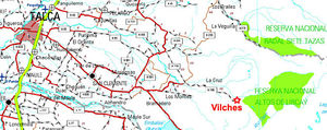
From Talca you must take the rout 115 towards San Clemente (East), a small town. There are 40 kilometres from Talca to the Vilches road to the left, the road is in good for most of the cars, half of it is covered by asphalt. From the start of the Vilches Road, there are 29 kilometres more, the first 9 with asphalt.
Public Transport
There are buses to Vilches from Talca Bus station. Frequency of this busses if nearly 2 busses per day during winter, and one almost one every hour during summer. Remember always ask for more information calling to the buss terminal station +56 - 71 - 235327.
Route description

- Altos de Lircay - Mirador deer: marked hiking trails, and impossible to lose. Takes about 3 hours. The viewpoint is the first view people have of the big headed. (See the description of this section in Seven Cups Vilches-the normal route)
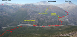
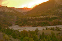
- Mirador del Venado-Shelter CONAF: From the viewpoint the trail descends to the lower Deer Valley. Then they must cross the river with water up to knee or so. Then be followed by the eastern shore to shelter a path CONAF relatively sharp. It is hard to miss. About 4 hours from the lookout.
- Shelter - Laguna tilefish: You should go up a valley by a well marked trail. It takes about 4 hours to the lake.
- You have to cross the water in the most passionate and moving north along the west bank of a river that goes into the lagoon. At some point you have to cross the river, which is wide but low, to reach a plateau that seems lunar. It is a good place to camp. One to two hours from Lake Whitey.
- Plain Lunar - Laguna: Since the lunar plain, you have to look good wherever it goes the route. All of that is uphill through an area of priedras pumice, like sand. When one has advanced a few hours, start to be visible to the north the hill Manantial Pelado, which looks very impressive and serves as a reference. It should reach the Lake, which lies at the foot of this mountain. In this area you can cross-country skiing, always walking towards the base of Manantial Pelado. They are about 6 hours to the lake.
- Laguna - 7 cups: You should continue to climb west to the saddle. This is the highest point of the trail, about 2600 meters. From Achaean is visible for the first time the valley of the Rio Claro, which is 7 cups. From the saddle, started down toward the valley. From there a path to the English park, where the ranger 7 cups. Since the park lagoon English, are about 7 hours.
Expected Time
At a normal pace, this trek should take between 4 and 5 full days.
Permits / Fees
- No permits required. A fee of CLP $ 3000 per day must be paid for Altos de Lircay National Reserve.
Recommendations
Although the time to enhance the path may be about 4 to 5 days is recommended to take the trip to relax, especially for the tremendous scenic beauty of the place. Two sites in particular are recommended to spend an extra day of rest: the sector of "little beach" located in lower Deer Valley, 10 minutes downstream from where the trail from the viewpoint of the Deer spliced with low and volcanic hot springs Descabezado Grande, which is located about an hour of the lunar plain, towards the huge lookout Maule.
Hiring guides
You can hire guides for this hike. The agency El Caminante, located in the foothills of the Maule Region (Office telephone 71-1970097, Mobile: 98371440) works with the guide Luis Ramirez, who can be called directly at 071 - 681992, or write to quizapuguiaventura@hotmail.com. He charges about $ 40,000 a day, depending on the route and the number of people.
Story of the route
Full story of the route (and many photos) in Sand and Foam
Waypoints in Google Earth
- Waypoints Vilches - 7 cups Deer Valley. To download the file right-click and then select "Save file as" (IE) or "Save link as" (Firefox, Chrome). By trying to open it directly, some browsers will show the raw code with the coordinates.


