Glaciar del Juncal (english)
Hay muy pocas o ninguna página que apunten a este artículo, puedes ayudar a hacerlo más visible poniendo un link desde la página del País/Actividad correspondiente |

|

|
Season
Trekking and Mountain Bike: September-May. Although the valley is high, its orientation does not allow for the accumulation of snow, making it a bad destiny for randonnée.
Access
Vehicle Access
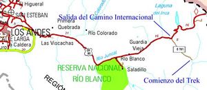
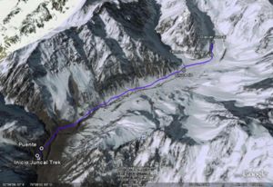
From Los Andes, you should take the international road to Mendoza CH-60. Continue on this road for approximately 50 km and exit immediately before the 20-curve slope that ends in Portillo, here begins a dirt road that penetrates the same valley that the railroad used to travel to Mendoza, you can still find traces of its tracks and installations. This road, is generally in good shape. After approximately 8 km you will see two houses, a summer residence for the valley muleteer. This is where the trek begins.
Access by Public Transportation
- You can take a bus in Santiago (at Los Heroes subway terminal) that goes to Mendoza. You have to pay the price of the total trip and negotiate a special price, since you will not be going to Mendoza. Ask to be left at Curva Cero (Curve Cero), or at the Galpon de Vialidad Juncal. From there, the walk is about 2 hours long.
- From Los Andes, take a "colectivo" to Rio Blanco. Ask to be taken either to Curva Cero or Los Hornitos. Walk for about 2 hours.
- From Los Andes take a bus to Rio Blanco. Hitchhike to the gas station to curve cero. Walk for 2 hours.
Route Description
Estimated Time
- Trekking: 4 hours to the the glacier and 3 hours back.
- Mountain bike: 2 hours to the glacier, 1 hour back.
Also consider 30 minutes of a car ride from the fork to the beginning of the trek.
Permits
This place is private property. It costs $1.500 CLP per person per day. There are no installations, and no signaling. For more information go to Parque Andino Juncal.
Leave no trace
Ask for permission to Catherine Kenrick:
- ckenrick@terra.cl
- 09 337 6336
- 02 228 8534
Kenrick Lyon Community
Ascending the Juncal
- To make an ascent of the Juncal (6.110m. IGM) yo may visit descripción de la ruta en Andeshandbook.
Waypoints on Google Earth and Map Source
Para descargar el archivo se recomienda hacer click con el botón derecho del mouse y luego seleccionar "Guardar destino como" (Internet Explorer), "Guardar enlace como" (Firefox) o "Save link as" (Google Chrome). Si se intenta abrir directamente, algunos navegadores abrirán el código crudo del archivo con el listado de coordenadas.
Contratar Guías
Es posible realizar este trekking en forma guiada:
 Trekking Andino: Viajes personalizados de alta calidad a atractivos Naturales, Patrimoniales y Culturales
 Contacto: info@trekkingandino.cl
 Facebook: Trekking Andino
 Instagram: @TrekkingAndino
 Teléfono: +56 9 78993379 (WhatsApp)
- Tralov Adventures: Private Hiking Tours in The Andes with certified guides / Tours privados y trekkings en Los Andes
- Contacto: contacto@tralov.com
- Facebook: Tralov Adventures
- Teléfono: +56 9 4949 1984 (WhatsApp)
- Contacto: contacto@anoka.cl
- Facebook: Anoka Experience
- Teléfono: +56978886115 (WhatsApp)
- Denomades.com: Tours y trekkings regulares y privados en el Cajón del Maipo y otros destinos. Contacto directo con los mejores operadores locales.
- Contacto: reservas@denomades.com
- Teléfono: +56 229551857
- Facebook: Denomades.com
- Contacto: ecotrekkingchile@gmail.com
- Facebook: Ecotrekking Santiago de Chile
- TripAdvisor: Ecotrekking Chile
- Teléfono: +56966028918 (WhatsApp)
- Ecochile Travel: Regular and private trekking trips at the Andes.
- Contacto: info@ecochile.travel, (56- 02) 25708826
- Flecha Extrema: Private Hiking Tours / Highmountain Expeditions around Santiago - Experience the Andes
- Contacto: contacto@flechaextrema.com, +56 9 65 61 72 77
- Facebook Turismo Flecha Extrema
- Teléfono: +56965617277 (Whatsapp)
- AndesBrown: Caminatas y Excursiones a la montaña central de Chile. Grupos guiados, guías federados.
- Contacto: info@andesbrown.cl, brown.fernando@gmail.com
- Teléfono +56988382014.
- Cajonoutdoor: Treking, cabalgatas y excursiones en todo el cajón del Maipo. Transporte de pasajeros desde hotel o aeropuerto al destino elegido. Guías bilingües expertos en la zona.
- Contacto: contacto@cajonoutdoor.cl
- Teléfono: +56991940429 - +56975275503.


