ENG:Cerro Pintor

|
|
|
| |||||||||||||||||||||||||||||||||||||||||||||||||
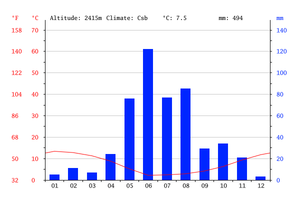
Appropriate time
- 'Trekking' : End of October or beginning of November at the beginning of May, when the snow has given way.
- 'Randonnée' : June to mid-September.
En auto
Desde Santiago, se debe tomar la ruta pavimentada G-21 en dirección a los centros de esquí y la mina Los Bronces. Son 15,8 kilómetros hasta la bifurcación que conduce a la mina, medidos desde la gasolinera Terpel que se ubica al final de Avenida Las Condes (centro de reunión natural de los esquiadores, ciclistas y montañistas que se internan en el valle). En esta bifuración, debe tomarse la derecha, y continuar por un camino pavimentado muy estrecho, que asciende abruptamente por pronunciadas curvas. Hay poca protección, por lo que en invierno debe conducirse con cautela. Son 16 kilómetros adicionales a lo largo de este camino de montaña hasta el pueblo de Farellones, en la curva 40, ubicado a 32 kilómetros de Santiago. En la curva 40 se llega a la villa Farellones y una bifurcación. Se debe tomar la izquierda (la derecha conduce a Valle Nevado y a la ruta a Piedra Numerada) y cruzar la villa de Farellones. Tras 4 kilómetros desde la bifurcación, se llega a una segunda bifurcación, que conduce al centro de esquí de El Colorado. Se debe seguir por izquierda. 1,1 kilómetros más adelante de esta segunda bifurcación se llega al inicio de la villa La Parva.
Atravesar toda la villa por su única calle. En el tramo superior, surgen dos bifurcaciones, que conducen a pasajes residenciales sin salida. No tomarlos y continuar el ascenso derecho hacia el Este. El pavimento se acaba y se inicia un camino de ripio en buen estado. A 700 metros din fin del pueblo, hay una nueva bifurcación: tomar la izquierda. Este camino conduce hasta el pie del andarivel Las Águilas, donde existe un amplio estacionamiento. Son 1,38 kilómetros de camino vehicular desde el fin de la villa.
Acceso en transporte público y autostop
Durante la temporada de esquí (mediados junio a fines de septiembre) hay minibuses por CLP$9000 (US$ 10.5 as of February 2026), valor ida y vuelta. Salen desde las 7.00 AM y retornan poco pasado las 17:00, la hora de cierre de los andariveles.
- SNOWTOURS
- Dirección: Huerfanos 502, al lado del cerro Santa Lucia, Barrio Bellas Artes, ahí cerca los dejan los metros Santa Lucia (linea roja 1) y Bellas Artes (linea verde 5)
- Fono: (2) 2982 8200 - (2) 3216 1106 - Whatsapp: +569 7997 3170
- reservas@snowtours.cl
- Salidas desde: Aeropuerto, Centro de Santiago (agencia Huérfanos con Santa Lucia), Hoteles y otros puntos.
- También ellos hacen traslados desde el aeropuerto al centro, tours a viñedos, Valparaíso y Viña del Mar, Isla Negra y otros lugares.
Son los mas económicos y los que salen mas temprano. Es muy fácil de llegar a ellos o a sus puntos de encuentro.
- KL Adventure
- Dirección: Supermercado Santa Isabel de Cantagallo, Las Condes, Santiago
- Fono: (2) 217 91 01
- Salidas desde: Aeropuerto, Supermercado Santa Isabel de Cantagallo, Ski Rental.
Están casi a la entrada del camino a los centros de esquí, solo servicio desde hotel.
- Ski Total
- Dirección: Avda. Apoquindo 4900 Local 37-46 (Edificio Omnium), Santiago
- Fono: (2) 246 68 81
- Salidas desde: Edificio Omnium, Supermercado Santa Isabel de Cantagallo, Mall Los Trapenses. En transporte público No se puede avanzar más allá del estacionamiento principal del centro de esquí, ubicado en la zona baja del mismo.
Description of the route
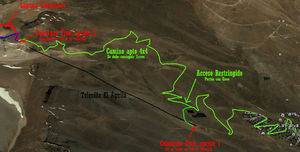
Desde el punto más alto del estacionamiento el andarivel Las Águilas (2970m) hay dos opciones para atravesar las pistas de esquí:
- Caminar/esquiar: Se puede estacionar a 3000m, un poco más arriba que el andarivel, y luego tomar el llamado "sendero andinista". Son 2,38 kilómetros de distancia horizontal y 560 metros verticales de ascenso hasta el punto en que termina el andarivel. Es un sendero bastante claro. Si bien existen numerosas bifurcaciones, el criterio general es apuntar hacia el Noreste, en dirección al final del andarivel. Si en algún punto no se está seguro, basta con usar las torres de los andariveles como referencia.
- Tomar el andarivel Las Águilas. Funciona solo en verano, sábados y domingos.
- Horario: 8:00 a 17:00 hrs.
- Última subida o bajada: 16:35 hrs.
- Adulto: CLP$11000 (US$ 12.8 as of February 2026). Es obligatorio tener tarjeta Parvapass para la compra. Se adquiere una sola vez por $5.000, en Caja de Campamento Base en Verano y en las cajas habilitadas en Invierno. Posibles cambios de precios acá.
- Menor: CLP$7500 (US$ 8.7 as of February 2026)
- Contacto: +56229642129 - verano@laparva.cl
- Ya no se permite ascender en vehículo propio
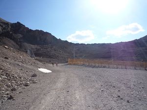
Desde la caseta superior del andarivel "Las Águilas" (km 0 - 3554m), ubicada a los pies del Cerro Falsa Parva (3.888m), son solo 200 metros hasta el Portezuelo Franciscano (3577m) por huella muy clara. Una vez en el portezuelo, se aprecia la Laguna Piuquenes en dirección Este.
Franciscan Portezuelo - Cerro Pintor
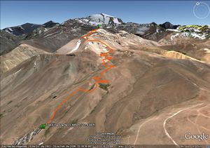
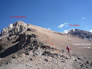
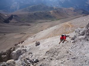
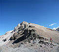
From here it is bent by the "edge" towards the N course to the road that goes up towards the Falsa Parva. This ascent has many paths, some more marked than others. The idea is to take the road with less slope and more "zigzageante" since the most direct climbs can be very tiring. It is important to note that all roads lead to the summit of Falsa Parva, so you can choose which one you want. The last part presents some rock formations that are not difficult to overcome. After this area is practically at the top of the Falsa Parva and the most difficult part of the whole journey is already behind. In total this corresponds to an ascent of about 200m of altitude and less than 1 km of road. Up here I should take 50 minutes of walking at a leisurely pace.
It is worth walking the few meters that separate us from the summit to appreciate the view of the ski centers and Stgo in the background. The path continues towards the N by a road that climbs gradually without steep slopes. After one kilometer you come to a fork in the road. The most marked (left) and that could be considered as the one that follows right is the one that borders Parva hill (4,047 masl according to IGM). The one on the right, which borders the cliff on the S slope, climbs towards the summit of Parva hill (there are about 800m of road with 140m of height).
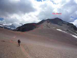
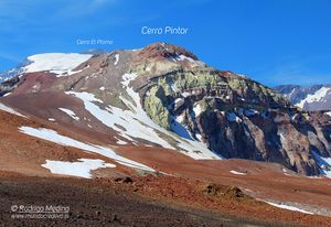
If we continue down, from the fork, there are 1.2 km to a sector of Pircas on the N side of the Parva (here you can take the road that climbs Co Parva on its N slope). From this point, and even from a little earlier, you can already see the Co Painter (4,180 meters above sea level according to IGM) in front with its unmistakable colors. In this sector there is a small shelter in which four people can fit to rest during windy days. From the summit of Falsa Parva hill up to this point it should take about an hour.
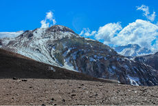
From here the summit of the hill is attacked, a path that still has a very clear footprint. The next 1.3 km pass mostly by a land without much slope, gaining height due to some steeper rise, but not very long. At the end of this stretch that is quite smooth you reach the O slope of the Co Painter. The climb begins with a zig zag for green terrain that shows that you are already in the Painter. The ascent is not made directly towards the summit, however the road begins to tilt the hill to the north until it reaches a new fork in the road. On the one hand this continues right towards an explana that is known as "Race Court". Towards the right this ascends the slope N of the Painter until its summit. The view you have of the Lead and the Leonera is spectacular. From the red shelter to the summit it should take about 50 minutes.
The return is made by the same path.
Expected time
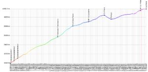
If you start from the base of the "Las Águilas" cable lift, consider 1h10m until the end of the cableway. From the cable car "Las Aguilas" to the Pintor peak it should take 2h40m hours at a quiet pace. The return should be faster, 1h30m from the top of the Painter to the house and 50m to go down to the base of "Las Águilas".
In total, if you start from the base of "The Eagles" are 4h up and 2h30m down. If you take the lift, it's only 2h40m up and 1h30m downhill.
Permits / Rates
- To enter Valle Nevado you must request permission in advance, since by internal regulations you need to have the registration of visitors. To do so, contact:
- E-mail: lsepulveda@vallenevado.com
- Teléfono: 24777000
- Free entry.
Recommendations
- Checklist: Aunque sepas perfectamente lo que debes llevar, es preferible chequearlo al empacar. Esta ruta ha sido clasificada como Type 2 equipment checklist: medium altitude route, no camping or snow, some cold. In summer or spring. In winter, consider Checklist of equipment type 3: route without camping, with snow.
- This trekking is very high, reaching almost up to 4,200 meters above sea level. Since it is a trekking that is done quickly (probably dawn at less than 1,000 masl and climb the day to the summit) the body does not have time to get used which can lead to symptoms of Puna or altitude sickness (headache, dizziness and others). It is important to hydrate well and steadily, in addition to maintaining a rhythm that is not very demanding when walking.
- As in any tour, we recommend the use of sunscreen, dark glasses with UV protection and a hat that covers the face and neck.
- A pair of walking sticks and good trekking shoes.
- Due to the height it can make something cold even on days that Stgo. It's hot. This is mainly due to the wind. For this reason it is recommended to carry at least one windbreaker. More warm clothing can be very useful (although it may also be that it is not used).
- Review the weather forecast of the mountains, as this may vary with respect to the city. This can be done here.
- Unless you want to do more exercise, it is advisable to get in the car or ride the first part since it is not the most attractive.
Meteorological Forecast
Contratar caballos y/o mulas
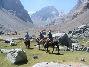
- Victor Araya Polanco +569 85098899 (sobrino de Don Luis Polanco Leal)
- Javier Morales: +56992918057
- Marco Berrioz: +56993478505
- Luis Patricio Quiroz Robles, alias "Pato-Lucho": 3215886, +56997790735 y +56992660628
- Javier Pinto: +56990973965
Los valores son del orden CLP$25000 (US$ 29.1 as of February 2026) por animal y por día. A ello se debe sumar el valor del caballo del arriero.
Photo Gallery
Laguna Piuquenes. 01-24-2010
Cerro Plomo from the road. 01-24-2010


