ENG:Bosque Llancahue
|
|
|
| |||||||||||||||||||||||||||||||||||||||||
General Description
The “Valdivian Forest:Llancahue”Heritage Route is an opportunity to learn about the interesting
temperate rain forest in a sector where this kind of vegetation formations have practically
disappeared,becoming thus a real biodiversity reservein the north of Region X.Llancahue stream
catchment basin,that covers an around 1,300 hectare surface,is the main water source to the
city of Valdivia,and the forests developed there are one of the most pristine landscapes of the
province of Valdivia,reason why this route provides a unique opportunity to know the landscape
that existed over 200 years ago across the area.
The catchment basin is a territory delimited by nature,basically by the limits of surface water
runoff zones that converge to asame river-bed.The basin,its natural resources,and its inhabitants
havephysical,biological,social,and cultural conditions that grant them particular characteristics.
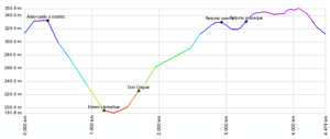
This is a 4.8 kilometer walk in a circuit that takes around 4 hours at a moderate speed,ideal for
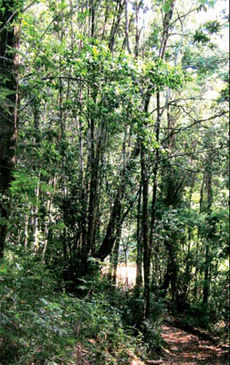
an all day long tour.You may find interesting flower species in this route,such as,majestic Coihues,
Tineos and Ulmos,the most varied climbing plants,a large number of ferns and lichens,among
others.In addition,this basin is one of the last fauna shelters,in consequence,you may find here
a wide diversity of birds, amphibia, and insects, and, if you are lucky, you may see a fox or a
woodpecker.
LLancahue, was recently protected throught a declaration as a Conservation and sustainable
Development Area, for that reason,incorporated to the National Properties Ministry's National
Assets Protected System. Trought this System, the Ministry's goals are related with the best
benefits, coming from aaddition of different kind of protection, planning, accesibility, managing
and third party administration instruments.

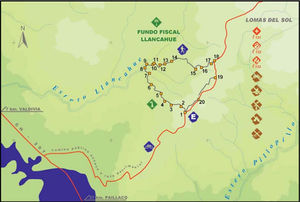
The first segment,that starts in the public road to Lomas del Sol,is a 2.5 kmtour which includes 13 guideposts of interest, where we can contemplate exuberant forests dominated by Coihues,as well as Llancahue stream. Species,such as,Coihue,Olivillo and Tepa may be identified in this segment, as well as realizing how important big trees are as an habitat for communities of birds,insects and other forms of life that live in the sector, and – ultimately – to understand significance of forests within water production process.
The second segment continues from Guidepost No.14 bythe medium part of the basin,until arriving to the start of the route, completing 2,3 kilometers that include 7 guideposts of interest.
The tour starts in an old forest where huge Olivillo, Ulmo, and Laurel trees may be observed, crossing then a mosaic of situations of different kinds of forests, observing Llancahue surroundings, and finally go back to the start point. What is interesting in this segment is the chance to admire a number of endemic species, typical of the Valdivian rain forest, allowing development of awide range of ferns, moss,lichens, mushrooms, and many fauna species,among which birds will make you the tour even more pleasant with their beautiful songs.
We will also see a very contrasting situation: Llancahue surroundings, dominated by wide Pine or Eucalyptus forest plantation surfaces, evidencing transformations that may be generated by human beings on the landscape.
Both segments,which can be traveled in one day,are only difficult to transit in certain sectors, where the track passes by flooded lands,such as,the stream sector, being therefore necessary to be prepared so as not to get wet. If you are not used to walk in this kind of terrain, consider additional time than provided in this topoguide. Evaluate times periodically in order to avoid being caught bythe night within the forest.
Access and Location
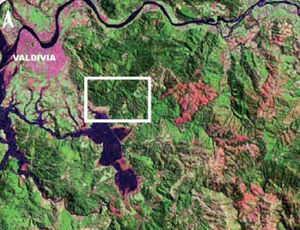
Llancahue lot is in south direction from Valdivia city, at less than one kilometer from the urban perimeter of the city and covers a surface of approximately 1,300 hectares.To access from downtown,you should take Ramón Picarte Avenue and move forward to the south until you exit the urban radius. At a few more than 5 kilometers from the square you will find at the left of the rubble road that goes inland through a hillside.Moving forward you will find a branching where you should take the road at the left and go upwards approximately 4 kilometers until you arrive to the start point of the route, where you can park your vehicle and begin hiking through the Heritage Route. avenue.In the corner of this avenue and Condell street, you could read the informative sign to the route.
Trail markings
The route is made up by 20 geo- referenced guideposts divided into 2 segments that depend on each other for a better orientation and understanding by visitors. Distance between guideposts varies depending on thematic characteristics of each interesting point and on orientation within the tour.Marks indicating the route have also been used for further support in the direction to be followed,avoiding thus to take paths that could drive you away from the route.
Descripción de la ruta
Segment 1
Distance: 2,5 km.
Walking Time: 2 hr, 50 min.
Characteristics: Walk starting in the old public road connecting the sector of Llancahue to Lomas del Sol by the South-East sector of the basin. Observation of forests made up by Coihue, Ulmo,Olivillo,Laurel,shrubs,lichens and ferns typical of the temperate rain forest.Passing by Llancahue stream.
Difficulty: Track on lands of moderate slopes,flooded in the stream sector during periods of maximum rains,between guideposts No.7 and No.8.Rubber boots or water-proof long leg boots required to walk this way.
From the start point,go ahead bythe left side road around 70 meters,and you will find a road bifurcation.Take the left road, walk a around 95 meters and you will arrive to Guidepost No.2.
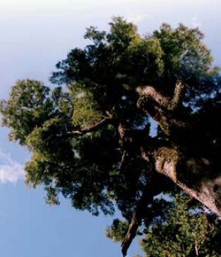
The forest observed here is dominated by big individuals of Coihue (Nothofagus dombeyi), a very common specie in the Valdivian temperate forest. This is one of the first species that initiate the formation of a forest in a naked land, mainly due to its low soil and nutrient requirements, and its high resistance to direct sun, reason why it is called a “pioneer” or “colonizer” specie.
Continue by the left side track around 300 meters,and you will find a new bifurcation.Take the right side road and follow for a few meters until finding Guidepost No.3.
In this Guidepost,you will find a big Coihue that fell down pushed by the wind,that is used as a micro-habitat allowing many moss,hepatica,and fern species to develop. It is also interesting to observesmall trees that are being established in the clearing caused by the fall of this tree.
Keep going for around 20 meters by the path located at the right side of the fallen tree,and you will see a big Coihue having a gap from the trunk base,allowing to observethe interior of the tree.This opening corresponds to a fire scar, indicating that this Coihue is a survivor of a big fire occurred many years ago. This fire gave rise to a new forest formation, which can been observed around us, and this Coihue undoubtedly provided a large number of seeds to colonize the burnt land again.
From this Coihue,take the right side road and keep walking around 135 meters without leaving the main road.Then,follow the track that goes down the forest for 240 meters until you arrive to Guidepost No.4.
If we watch carefully,we will see some plants that are entangled in tree trunks and branches – these are climbing plants which are gradually climbing up from the forest floor in order to reach the tree tops, obtaining thus precious sun rays allowing them to manufacture their own feed. But many of these climbing plants should fight hard against trees to tryto get to the upper forest canopy, a battle that ends when any of them wins:The tree succeeds in absorbing the climbing plant that climbs up through its trunk and branches,or the climbing plant strangles the tree preventing it from growing and reaching sun light. From here,walk around 150 meters until arriving to Guidepost No. 5, always by the main path.
Keep walking for 150 meters by the path and then follow the right side track.Around 20 meters ahead,you will find a clearing in the forest, to your right, where a typical underwood specie grows, Fuinque (Lomatia ferruginea). You will arrive to a bifurcation after walking around 55 meters from the Fuinques.Take the left side road and keep going for 180 meters until arriving to Guidepost No.6.
Llancahue forests are within a delimited territory called basin.This is in turn divided into a number of micro-basins that generate small rivulets that flow into a main course, Llancahue stream. Small water courses are called tributaries and we can observe the micro-basin that form it to the left.
Go ahead 120 meters until finding a rooted out Coihue which lays across the road.After passing the tree,keep going around 200 meters to the right until arriving to Guidepost No. 7. You will have to pass by a small rivulet that is tributary to Llancahue stream before arriving to this Guidepost.
This stream varies over the different seasons according to rains:its highest flow in winter time,becoming over 5 meters wide and around one meter deep,in average,and its lowest flow in the summer,when there are little water reserves in the ground, becoming around 3 meters wide and 50 cm deep, in average. When summer ends, the first rains start reloading soils and underground sheets of water, allowing thus the cycle to start over again.
From Guidepost No.7,take the right side road, going down around 250 meters by a slight slope until you arrive to Guidepost No. 8. Around 20 meters before arriving to this Guidepost, when walking by the surroundings of Llancahue stream, we will find a new tributary to Llancahue stream, but bigger this time,that you will have to overcome by the edge of the road. Species that prefer wetter sectors develop in sectors near water courses, such as, female Mañío (Saxegothaea conspicua) and Melí (Amomyrtus meli).
Guidepost No. 9 is located only 80 meters ahead.
When walking away from the stream, we can observe big Coihues, that grow better in wet places.
From Coihue,go on 20 meters by the road that gradually goes up and take the right side track,since the left side track will lead you directly to Llancahue stream. We recommend you to go watch the stream, but come back to this same spot, avoiding thus to get lost with calculation of distances.
Once you visit the stream, keep walking 60 meters from the spot where the road divides into two and go on 60 meters always following the main track (do not take the secondary road which goes up a slope, to the right).
Keep going for another 50 meters until you see beautiful Melíes that may be clearly distinguished for their slim shape,their delicate aroma, and their whitish bark. Guidepost No. 10 is located 60 meters ahead. While we get far from sectors of higher slope and less access,landscape begins to change. This is due to the human being’shand starts to become visible, which is evident when you find a plain site with coal rests.
From this guidepost move forward 70 meters by the road which has a slightly more pronounced slope than the tour up to this stage until you find The Chauman, Traumén or Sauco of devil (Pseudopanax laetevirens) is an endemic tree of Temperate Forests of South America and lives mainly in wet and woodest zones,near water courses. Moveforward 120 meters bythe main path until finding Guidepost Nº 12.
Once again we encounter the monarch of these woods,this time it relates to a Coihue of large proportions which certainly has given life to many generations of the wood acting as “seed”tree.This type of trees survives to adverse conditions, such as fires and large sliding of earth and, once land is uncovered, they disseminate their seeds and generate new generations of plants that slowly form new forests.
From this guidepost, move forward about 100 meters, where you will experience a change of landscape; you will be surrounded byentangled shrubs, this indicates you are in Guidepost Nº 13. As we come closer to the communities that live in the surroundings of Llancahue basin, action of man is increasingly more evident. In this guidepost we can appreciate a large Quilanto that generated for the excessive cutting down of trees, concentrated in one area in particular
Move forward by the road to the interior of the quilanto approximately 260 meters to begin the next segment
Segment 2
Distancia: 2,3 km.
Duración: 1 hr, 40 min.
Characteristics: Walk by the medium part of the basin. Observation of different situations of forests dominated by Ulmo,Canelo,Tineo, Myrtaceous,and Mañíos,accompanied by various climbing plants,ferns,and mosses. Visit to the Valdivian rain forest both in young and adult status.
Difficulty: Track on lands of moderate slopes.This walk requires rubber boots or water-
proof long leg boots.
Types of wood we find in Llancahue correspond mainly to Valdivian Forest,a real water saturated jungle during winter and slightly humid during summer months,forming an intricate vegetal world where big trees are next to countless species of bushes, climbing plants, epiphyte, herbs, moss, lichen, mushrooms and rich fauna comprised by vertebrate and invertebrate animals, and microorganisms. As a consequence of the different intensity with which the human being and action of nature have intervene their surface on time,they can domain new shoots or secondary forests mostly comprised by Coihues of the same age (coetaneous),mainly originated byfires and large sliding of earth,and adult forest with different alteration level, showing diverse structures based on fairly excessive interventions, caused by human beings for the obtention of timber- yielding goods. Nevertheless, in Llancahue there are also some sectors subsisting with practically unaltered forests which show us the beauty and magnificence of woods from ancient times.
The vegetation we can observein this guidepost is the typical Valdivian Forest, comprised by rich vegetable communities distributed in different layers or strata under the tree-tops of older trees. Throughout the grove dominant species (trees of higher height and magnitude) are varying from one situation to another where big evergreen trees prevail with wide leafs, such as the Ulmo (Eucriphya cordifolia), Olivillo (Aextoxicon punctatum), Tepa and Laurel (Laureliopsis philippiana and Laurelia sempervirens).These can be differentiated for the hairy appearance of the Ulmo in new branches and leafs,for the shiny green leaf with the back full of small brown dots giving the Olivillo a rough texture and for the pleasant fragrance expelled by leafs with serrated edge of Laurel and Tepa trees.
Ferns,moss and lichens are also very important components of the wood, growing on the soil, over trunks of old trees and trees fallen. It is interesting to note the presence of moss Dendroligotrichum dendroides with the appearance of miniature tree, which is the biggest moss of South America reaching up to 40 centimeters of height.In more humid habitats,abundant epiphytes grow on tree trunks and branches, being the most common the Chupalla and ferns “Película [film]” of Hymenophyllum gender.
From this point, walking about 20 meters you will find a branching where you should take the road to the left, which climbs through the slope,but do not worry,because after moving forward 150 meters you will be contemplating a resting place, reason why we could spend some time to relax and observe the forest in all its dimensions.
If we focus our look downwards and paying attention to ferns,we can see Ampe or Palmilla (Lophosoria quadripinnata),the biggest fern you can watch in this route.It is easy to recognize it on site due to its large frond 4 times pinnate,light green of the front face and blueish white on the back. Its large branch is very typical,easy to observe in the wood with fronds that could reach 5 meters long. The Ampe is a fern with medicinal properties.Its rhizomes are used in infusions to cure wounds. Hairs covering young branches are used to stop hemorrhages.
The fern Costilla de Vaca [cow’s rib] or Quilquil,another outstanding fern in this route,looks like a small shrub. Leafs of ferns are called fronds and are comprised byarachis that would be the stem, to which thorns join, which are like little leafs.It must be noticed that in popular medicine the fern Costilla de Vaca is used to cure sight diseases.
From resting location walk always taking the path at the right side and run 250 meters until arriving to a large tree at the right side of the road, it is the Tineo (Weinmannia trichosperma), an endemic tree of Temperate Forests of South America. Its trunk is straight and cylindrical of light gray bark, reaching height of more than 30 meters and with trunks of more than 1 meter diameter, characterized bythe peculiar leafs of rhomboidal aspect.Timber of Tineo is hard and has a beautiful dark vein, very resistant to humidity for which it is used for construction of crossbars, fences, cart wheels and sleepers.
Move forward 190 meters always taking the road to the left,crossing a beautiful wood of Olivillo,Ulmo and myrtaceous next to huge canelos offering their huge branches for bird shelter and purple fruits as food. Continue for another 160 meters until arriving to a new branching, where you should take the road of the right to arrive to Guidepost Nº 15 after walking 50 meters. Between guideposts 14 and 15 we will walk just between the limit of two micro basins that discharge their small water courses in Llancahue stream. For this reason it is possible to hear the noise of water flowing at both sides of the path.
Woody formation observed in this guidepost corresponds to a new shoot of Canelo, which can be recognized for its shiny green leafs on its front side and grayish white on the back. It is a tree of straight and cylindrical trunk that could reach up to 30 meters high and 1 meters of diameter.It has a thick,smooth and soft bark, of gray color being an endemic variety of Sub Antarctic Woods of Chile and Argentina.
This tree is sacred for the Mapuche people for its magic and curative properties. It was used to treat tumors, swellings and eruptions on skin, to lower a fever, stimulant, diuretic, antiscorbutic, etc. Infusion of leafs was used as intoxicant narcotic to alleviate delivery pains, teeth and stomach aches. Sailors from the XVI century used bark of this plant for treating scurby.
In this beautiful new shoot we can observe huge trees of Ulmo, Olivillo and Tepa which tree-tops exceed those of canelos, giving protection and shelter from strong winds in winter.
Continuing the tour from Guidepost Nº15,always through the forest with underwood of quilas,move forward 50 meters to arrive to Guidepost Nº16, located next to two large Tineos.
It is a location representing the diversity of Valdivian Forest species. At the right of the road you can see two adult trees of Tineo and at the left large canelos.In addition,you can notice smaller trees such as the Arrayán and Chaumán, the fern Pallante (Hymenophyllum caudiculatum) and Poe. Likewise, you should note the existence of the medicinal climbing plant Quilmay and Medallita in this site.
Tepa and some myrtaceous form a second stratum or soil in the wood, making evident the path of time and interaction between all components of the ecosystem, where Tineo and Canelo,probably the first species that arrived by winds or birds carrying their seeds, prepare the soil, offer shadow and protection so that new species populate the forest.
From this guidepost move forward always preferring the track at the left. By moving forward 300 meters you will find a road going downwards through the slope, you should not take it.Follow straight for about 30 meters where you will find Guidepost Nº 17.
The type of vegetation we observein this guidepost is very peculiar as it is dominated by Oak (Nothofagus obliqua) a big tree of caduceous leafs, namely, they loose from branches during fall and winter and appear again in spring season.These oaks probably correspond to one of the last existing thickets in Llancahue,as timber of great value and excellent quality, long-lasting and unputrescible, was commonly used in construction during the last century, mainly to fabricate posts, railway sleeperies,beams and pillars of housing and also furniture,doors and windows.
The great diversity observed again must be noticed, as Oak is next to Ulmos and myrtaceous.Underwood with Hazel Tree, Fuinque and the beautiful Tupa shrub which leafs are ashy green for being densely covered with hair and contain bitter and poisonous latex.Its big purplish red flowers appear at the end of spring and summer decorating the floor of the wood.
Continue through the road for about 30 meters and turn to the right.Move forward about 40 meters until you reach the public road to Lomas del Sol.
When you leave for a moment the diverse woods of Llancahue,exiting to the public road to Lomas del Sol,we can see how landscape varies as a consequence of radical interventions of the human being on native forests.Take the public road to the right (going downwards bythe road).
If we do a little effort and try to imagine this same landscape 100 years ago, we could observe this or more beautiful woods as those we have just visited,where today there are only large extensions with Pine or Eucalyptus plantations.Where in the past pumas,foxes,pudús [Chilean mountain goat], many species of birds and other smaller organisms inhabited this place, today you can only observe an unpaved road with exotic vegetation on the edges (Ulex, Brambleberry,Broom),which is very aggressive and flood any place with no vegetation,replacing little bylittle native vegetation that fights for its space.We can observe some native species such as Maqui (Aristotelia chilensis),Radal (Lomatia hirsuta), Tupa and some Coihues which in friendly attitude extend their branches to the red road to shelter us from sunlight.
Move forward 260 meters by the public road until arriving to an adult plantation of pines at your left.From here, walk about 170 meters and enter again to the wood through an access at the right of the road.
When entering again from the public road to the new shoot you can immediately feel humidity and freshness at the interior.In these new shoots, we will find two meadowlands indicating that antropic pressure does not end in sectors of better access and shorter distance to some road as we will observebovine cattle tracks,they use these meadowlands in the middle of the forest to shelter from the cold and rainy winter in the south of Chile.This situation is a great trouble for the settle of new native plants (natural regeneration of the wood),because animals trample over and trim twigs (eat) small plants trying to settle in lands cleared by man.
From Guidepost Nº 19, take the main road to the left and move forward 270 meters to arrive to a small meadowland in the middle of the forest.From there,take the road to the right and move forward 180 meters until you reach the second meadowland surrounded by an evergreen new shoot comprised by Tepa, Hazel Tree, Olivillo and some species of the myrtaceous family.
Moving forward to the road of the right (interior of the wood),50 meters from the meadowland, you should take the road of the left and walk 100 meters until you find the edge again between the public road and Llancahue, which will indicate that you arrived to the last guidepost of this route,the Nº 20.
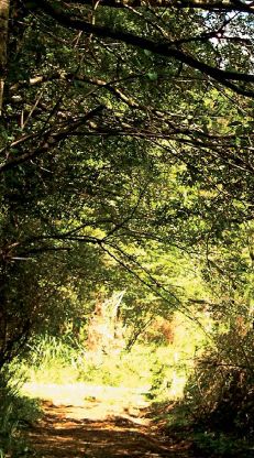
From this guidepost move forward 50 meters in direction to the wood and walk 400 meters moving inland through the road that has various tracks; prefer always the one of the left. Probably, you will find familiar the kind of wood that surrounds you, and it is because it is the one we observed at the beginning of the route.This gives us the possibility to meditate a little about we have seen and how in few years we can destroy it if we do not appreciate it.
We must always remember that we, human beings,as well as plants and birds,are part of this ecosystem and need it to live.The wood is generator of important functions,such as water production, which in the case of Llancahue supplies the whole city of Valdivia,oxygen liberation of plants, vital to all living creatures,which also absorb gases that affect us negatively and,certainly,a source of recreation and contemplation allowing us to learn and understand a little the nature of which we are part.
On the other hand, we also obtain goods from forests,such as timber to manufacture our furniture and homes, firewood for cooking and heating, food, such as fruits and mushrooms, among many others. Conservation of forests is possible if we make a reasonable use of them and, for doing it, we need to know where it originates,how it behaves, who live therein and treat them with respect and love.
Guideposts
| <googlemap version="0.9" lat="-39.854501" lon="-73.138016" zoom="15" height="500" width="500" type="satellite">
http://www.wikiexplora.com/kml/Bosque_Llancahue.kml </googlemap> |
Recomendations
- Take with you the Rutas Patrimoniales guide pdf Version digital version
- Bring water-proof and thermal clothes for more comfort and safety.
- Bring high leg rubber or plastic boots.
- Be previously informed on weather conditions for a better planning of the excursion.
- Try to not take the tour in days with abundant precipitations, the track is flooded and it is possible that the route is interrupted by flow swellings of the Llancahue Stream.


