Plantilla:Grey - Paine Grande en
The refugio is beside the lake of the same name, in the middle of a lenga forest, adjacent to a sandy beach. From there also comes another trail that leads to the viewpoint of the glacier. There is camping, storage, shelter and guided walks over the glacier.
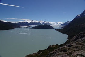
The trail to Lake Pehoe advances through flat land, in a southeasterly direction. The terrain is smooth, and after 15 minutes there is a short climb and then it continues at the same altitude, to reach the bridge over the river Olguin, located on a narrow stretch of the river. After half an hour from the refugio the trail climbs quite a bit through rough terrain. It is a muddy area, with abundant vegetation. After the highest point is reached, the path continues with the Grey Lake to our right. Later, there is another climb, an area where is not uncommon to find some water dripping. In this new ascent, there is a viewpoint towards the glacier, lake and its icebergs. Then follows a rocky path, that ascends to 450 m.
After just under 2 hours of walking, having left behind a flat stretch with small lengas, the trail begins to descend gently to the "Quebrada de los Vientos" area, right after a section of rounded boulders where the south beach of Lake Grey is visible, normally populated by ice (and tourists, given its access by road). Walk around the side of a small lagoon and continue to descend, with the incredible emerald Lake Pehoe as backdrop.
Refugio Paine Grande (ex Pehoé) is situated adjacent to Lake Pehoe and has a wide but windy paid camping ($ 4000 p / p). It is commonly fully booked, so get there early if you plan to sleep. There are toilets and well-stocked store (even T-shirts and souvenirs are sold). There is also a hotel. From this point you can either:
- Continue the trek to Valle del Francés (thes route this article describes)
- Walk to the park entrance along a flat (and somewhat boring) trail, flanking the Grey River (5 hours),
- Take the catamaran to Pudeto .

