Diferencia entre revisiones de «ENG:Altos de Cantillana»
(Página creada con «en:ENG:Altos de Cantillana category:KMZconTrack Category:Parche Cordillera de la Costa {{Indexada}} {{RutaForme |Actividad=Montaña |País=Chile |CiudadesChile=...») |
|||
| Línea 1: | Línea 1: | ||
| + | {{GT}} | ||
[[en:ENG:Altos de Cantillana]] | [[en:ENG:Altos de Cantillana]] | ||
[[category:KMZconTrack]] | [[category:KMZconTrack]] | ||
Revisión actual del 19:31 1 jul 2019
|
|
|
| |||||||||||||||||||||||||||||||||||||||||||||||||
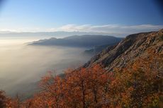
Summit of the Mountain range of the Coast, near Santiago and of easy access, with beautiful views to the mountain range of the $ andes and the surroundings of the lagoon of Aculeo. In autumn the red oaks are particularly attractive.
Appropriate time
All year. It is recommended mid and late May, when the oaks are red. The second best time is July or August, when there is some snow on the plateau. Full summer - January to March - is somewhat arid.
Access
In vehicle
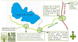
Exit from Santiago on route 5 south and take the exit "Champa-Kennedy" towards the coast (km 50 approx). Go along the G-546 road (Champa-Rangue road) until kilometer 19, after passing through the "Las Cabras" bridge, turn immediately to the right to enter the reserve.
By public transport
From Santiago take the bus "Aculeo-Rangue" from Buses Paine in the San Borja terminal (do not take the bus "Altos de Cantillana" that goes to a village of the same name as the reserve 30 km away). The buses leave at 10 minutes and 40 minutes (every half hour) between platforms 1 and 4 of the terminal. Ask the bus driver to go down in the estuary the goats past the Alto Laguna condominium.
Description of the route
Km 0 - Km 4: the route starts with a wide dirt road that goes into a forest and narrows gradually until it becomes a path. This part of the route does not have good signage and there are several ramifications. Small wooden sticks painted red on top help in some parts to follow the route. The waypoints included in this part of the route give indications on which direction to take in some points.
Considering only the vehicular roads that appear, without taking possible shortcuts by paths, the sequence that must be followed is as follows:
- Km 1.6 (442m): Left
- Km 2.24 (486m): Left
- Km 2.35 (495m): Left
- Km 2.41 (501m): Right
- Km 2.91 (544): Left
- Km 3.02 (546): Turn 90º to the right
Km 4 - Km 7: end of the road and start of the trail. The route is still in the forest, through a gate and later a bridge. Shortly before reaching a pass (km 6.3 approx) the forest becomes thinner, then the trail is completely clear shortly before reaching a sharp edge. From this point you can already have beautiful views of the surroundings.

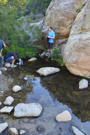
Km 7 - Km 10': the path follows the edge until km 8 approx. where it takes the west side Further on, it passes through the Puerta del Espino. The sign indicates an altitude of 930 masl, but 'that number is incorrect' : it is located at 1250 m. Immediately after, a reserve guardhouse is located. Then you go down a few meters and you reach the fork with the route to Horcón de Piedra. To follow Altos de Cantillana, take the path that points south (there is adequate signage at this point). At the fork, down a few meters, there are some pools where it is possible to stock up on water and have a nice time. This is the only point with 100% safe water on the route.
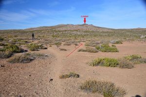
Km 10 - Km 15.5: the path climbs up the slope until it reaches the edge, then it advances through it until more or less the 12 km where it retakes the western slope until reaching an area of lower slope around km 13.5 . This section of the route is progressively stony, which makes the walk somewhat difficult, but it is very light obstacles. When approaching the oak grove the path becomes less clear, but the trees are clearly distinguished from a suitable distance and arriving should not represent any problem. This is a good camping area, very nice and with beautiful views on the east.Km 15.5 - Km 22.5: to reach the summit you must go south on the plateau. The path is not clearly distinguished from the oak grove, but surrounding the elevation to the south can be easily found. The walk through the plateau is very pleasant, with little slope, views of oak forests and the main peaks of the Andes in this area.
The summit itself is a rocky promontory of about three meters that requires a very simple tiny crawl. Unfortunately, the entire somital area is full of antennas, cables and other remains of industrial facilities. On the other hand, the view is magnificent. It can be seen from Mount Aconcagua in the north to Descabezado Volcano in the south.
Rates / permits
You must pay $ 4000 (US$ 6.5 as of May 2018) pesos to enter the reserve for the day. If you also want to camp inside, the figure goes up to $ 6,000
You have to book to be able to enter, and only a maximum of 30 people per day are allowed. They open only weekends and holidays. Reserve
Recommendations
- Checklist: Aunque sepas perfectamente lo que debes llevar, es preferible chequearlo al empacar. Esta ruta ha sido clasificada como Type 4 equipment checklist: low altitude route, without snow or cold, with camping.
- There is only 100% safe water at a point on the route, the pockets near the fork with the route to Horcón de Piedra. If camping, it is recommended to go with two liters of water per person up to this point and then continue with at least three liters per person. There is also a small fountain very close to the Roblería, which has water all year round, but in dry periods drains very little and may not be absolute confidence (although it serves with total security to cook, at least).
- As in any visit to the mountain it is advisable to bring sun protection and dark glasses with UV protection.
- Good trekking shoes and walking sticks are not essential but they make the route quite easy.
- Warm clothes for the night.
- Pets are not allowed in the Altos de Cantillana Nature Reserve.
- Night walking is not allowed
- The maximum departure time of the administration is at 6:30 p.m. If you arrive by car and there is a good chance of returning later than that, it may be a good idea to park outside the premises.
Cavalcade
- For $ 315,000 it is possible to make this route on horseback with Altos de Cantillana Expediciones & Ecoturismo. Take 'three days' . The minimum number of participants is 4 and the maximum 8. Includes: Specialized guide, access to the reserve, 2 breakfasts, 3 lunches, 2 dinners, horses, pack animals (food and camping accessories), muleteer, tents (capacity 8) pax), accident insurance (up to 64 years)
Criticism of Wikiexplora editors
As editors of Wikiexplora, we think it is appropriate for private properties to charge reasonable amounts for access, as long as this allows the environment to be conserved and the routes open to the general public. And what is charged for access to enter and camp in the Altos de Cantillana Nature Reserve is certainly reasonable. But what is problematic is that, despite the charge and the restrictions that are imposed, the initial sector, where the walker faces numerous bifurcations, 'lacks signs indicating the route' . It is also regrettable that the Puerta del Espino sign indicates an altitude lower than the real one, a reason for serious confusion for those who lack instruments to measure altitude and have adjusted time to achieve their destination.
Photo Gallery
Vista desde el Oeste. La meseta del Alto de Cantillana corresponde al tercer filo hacia atrás. En su extremo derecho se aprecia el cerro Horcón de Piedra. Imagen: Juan Francisco Bustos
Revisa la lista completa de 623 rutas de trekking y las 345 rutas de montaña en Chile
|
- Páginas que usan argumentos duplicados en invocaciones de plantillas
- Articles translated automatically that need human revision
- Drafts
- KMZconTrack
- Parche Cordillera de la Costa
- Indexada
- Rutas
- Routes in english
- Montaña
- Rutas de 2 días
- Montañas de dificultad Muy Fácil
- Rutas con checklist
- Trekking y Montaña en Chile


