Diferencia entre revisiones de «ENG:Glaciar San Francisco / Monumento Natural el Morado»
| Línea 1: | Línea 1: | ||
| − | |||
{{Trekking Chile}} | {{Trekking Chile}} | ||
{{Rando Chile}} | {{Rando Chile}} | ||
| Línea 21: | Línea 20: | ||
== Best season== | == Best season== | ||
| − | *'' 'Trekking''': The | + | *'' 'Trekking''': The best time for trekking is between October and May, Ideally November and December, however you may not be able to reach the mirador of the glacier due to large amounts of snow hanging arond in October and November. |
| − | *'' ' | + | *'' 'Ski touring''': Between June and late September. Even then this depends on how the winters gone and when the last snowfall was. It may well be necessary to load the skis along the first installment. |
== Access == | == Access == | ||
===By car === | ===By car === | ||
[[Image: Mapa_monumento_morado.jpg|thumb|200px|right| Map trekking the Glacier access to San Francisco. The start of the trek is marked with a red star (bottom right). Map. Image: [http://www.vialidad.cl Department of Roads]]] | [[Image: Mapa_monumento_morado.jpg|thumb|200px|right| Map trekking the Glacier access to San Francisco. The start of the trek is marked with a red star (bottom right). Map. Image: [http://www.vialidad.cl Department of Roads]]] | ||
| − | {{Access Baños Morales}} | + | {{Access Baños Morales}} On the road from San Jose de Maipo take a right where the road forks. The road then crosses the river and climbs a bumpy but short road to the village. On approaching the village take the left fork which crosses back acroos the river and up to a car park surrounded by stalls offering various products and services for tourists. |
=== Public transport and hitchhiking === | === Public transport and hitchhiking === | ||
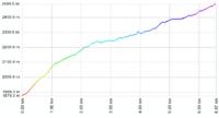
[[Image: Perfil_trekking_glaciar_San_Francisco.png|thumb|200px|left|Profile altitude trekking. The vertical scale is increased]] | [[Image: Perfil_trekking_glaciar_San_Francisco.png|thumb|200px|left|Profile altitude trekking. The vertical scale is increased]] | ||
| Línea 37: | Línea 36: | ||
[[Image: Valle_Aguas_Panimavida.jpg|thumb|150px|right|View of the Valley of the Waters of Panimávida. Photo taken on the return walk from north to south]] | [[Image: Valle_Aguas_Panimavida.jpg|thumb|150px|right|View of the Valley of the Waters of Panimávida. Photo taken on the return walk from north to south]] | ||
| − | From CONAF, the route climbs steeply for about 45 minutes. The trail enters the valley, | + | From CONAF, the route climbs steeply for about 45 minutes. The trail then enters the valley, joining an old vehicular road that zigzags upwards. After about an hour, once the path has climbed this initial lip of moraine, the valley narrows and you come to Panimávida Waters, a number of mineral water wells. Thereafter, the gradient decreases, and the path continues up the valley, with the impressive south face of Morado as a backdrop. After about 1-2 hours of easy flat walking you will reach Laguna de Morales (often mistakenly called "Laguna Morado" For this laguna, see [[Glaciar del Morado]]). This makes a picturesque end point, but it is advisable to continue another hour more, approaching the base of the glacier San Francisco. The trail is somewhat less clear, the slope increases and you are more likely to find snow between October and December. |
===Expected Time=== | ===Expected Time=== | ||
| − | At a normal pace, this trek should take about 4 hours between CONAF and the viewpoint of the glacier. However, what is meant by "viewpoint" is not a defining point, but rather an area. | + | At a normal pace, this trek should take about 3-4 hours between CONAF and the viewpoint of the glacier (the orginal article said 4 but this seems an overestimate). However, what is meant by "viewpoint" is not a defining point, but rather an area. It is a total of 16km there and back with 600m of acsent. |
== Permits / Fees == | == Permits / Fees == | ||
[[Image: Mirador_del_Morado.jpg|thumb|150px|right|South wall of the Purple]] | [[Image: Mirador_del_Morado.jpg|thumb|150px|right|South wall of the Purple]] | ||
| − | * | + | * Entrance to Monumento Nacional El Morado is $ 1,500 per person. |
== Recommendations == | == Recommendations == | ||
| − | * To climb the Mirador del Morado, the south face of | + | * To climb the Mirador del Morado, the south face of San Francisco or the difficult south face of Morado, we recommend looking at the respective routes in the Andeshandbook: |
** [http://www.andeshandbook.cl/cerro.asp?codigo=27 Mirador del Morado] | ** [http://www.andeshandbook.cl/cerro.asp?codigo=27 Mirador del Morado] | ||
** [http://www.andeshandbook.cl/rutas.asp?codigo=138 San Francisco. Route Checha, direct variant] | ** [http://www.andeshandbook.cl/rutas.asp?codigo=138 San Francisco. Route Checha, direct variant] | ||
Revisión del 15:12 11 ene 2010

|

|
<googlemap version="0.9" lat="-33.799691" lon="-70.05" zoom="12" width="380" height="270" type="satellite"> http://www.wikiexplora.com/kml/glaciarsanfrancisco.kml (I)-33.823082, -70.061874 Pueblo de Baños Morales, punto de partida. (F)-33.772584, -70.072517 Glaciar San Francisco, fin del trek.
</googlemap>
Best season
- 'Trekking': The best time for trekking is between October and May, Ideally November and December, however you may not be able to reach the mirador of the glacier due to large amounts of snow hanging arond in October and November.
- 'Ski touring': Between June and late September. Even then this depends on how the winters gone and when the last snowfall was. It may well be necessary to load the skis along the first installment.
Access
By car

From the intersection at las Vizcachas (Avenida Camilo Enríquez and Avenida Eyzaguirre, km 0), take the road G-25 towards Cajón del Maipo, and follow it until km 65.1 (asphalt ends in the km 66.3 just before Lo Valdés) where there is a bifurcation. To the left, it leads to Baños Morales along a dirt road, located on the other side of the El Volcán river. Between June and September this road might be closed if there have been recent snowstorms. You can check the road status with Carabineros at San Gabriel (+56228611008 y +56228612290) although their answers tend to be on the conservative side. On the road from San Jose de Maipo take a right where the road forks. The road then crosses the river and climbs a bumpy but short road to the village. On approaching the village take the left fork which crosses back acroos the river and up to a car park surrounded by stalls offering various products and services for tourists.
Public transport and hitchhiking
Public busses to Cajón del Maipo
- Public busses (subsidized): El Alfalfal – San José de Maipo; Baños Morales (Lo Valdés) – El Volcán – San José de Maipo and El Volcán–San José de Maipo cost CLP$1200 (US$ 1.4 as of February 2026). It can cost as little as $300 for shorter distances.
- Turmaipo: From October to January first, Saturdays, Sundays and holidays. Daily in January and February. Departures at 7:30 AM and from Baños Morales at 18:000. It departures from Terminal de Metrobuses Bellavista de la Florida, platform E, or from Las Mercedes (Puente Alto) around 7:50. In San José de Maipo at about 8:35, to finally reach Baños Morales around 10:15. CLP$8000 (US$ 9.3 as of February 2026) round trip to Baños Morales, cheaper for shorter distances. Phone: +56228424208, +56222830082, +56228611518, cell +56982896718
- Buses TurMarzur: Phone +56993357800
Private vans to Cajón del Maipo
- Turismontaña: +56991219203
- Baños Morales: CLP$10000 (US$ 11.7 as of February 2026) round trip, per person, $12000 if you return a different day.
- Embalse El Yeso: CLP$10000 (US$ 11.7 as of February 2026) per person
- Turismo Arpue: CLP$10000 (US$ 11.7 as of February 2026) per person. Bookings at least 24 hours in advnace +56222117165 - +56226818475 cel: +56999320108
Both companies depart from Baquedano Metro Station (red and green lines), at the side of Telefónica building. The departure is at 7:30, to reach Baños Morales at about 10:00.
Route description
From CONAF, the route climbs steeply for about 45 minutes. The trail then enters the valley, joining an old vehicular road that zigzags upwards. After about an hour, once the path has climbed this initial lip of moraine, the valley narrows and you come to Panimávida Waters, a number of mineral water wells. Thereafter, the gradient decreases, and the path continues up the valley, with the impressive south face of Morado as a backdrop. After about 1-2 hours of easy flat walking you will reach Laguna de Morales (often mistakenly called "Laguna Morado" For this laguna, see Glaciar del Morado). This makes a picturesque end point, but it is advisable to continue another hour more, approaching the base of the glacier San Francisco. The trail is somewhat less clear, the slope increases and you are more likely to find snow between October and December.
Expected Time
At a normal pace, this trek should take about 3-4 hours between CONAF and the viewpoint of the glacier (the orginal article said 4 but this seems an overestimate). However, what is meant by "viewpoint" is not a defining point, but rather an area. It is a total of 16km there and back with 600m of acsent.
Permits / Fees
- Entrance to Monumento Nacional El Morado is $ 1,500 per person.
Recommendations
- To climb the Mirador del Morado, the south face of San Francisco or the difficult south face of Morado, we recommend looking at the respective routes in the Andeshandbook:
Waypoints in Google Earth
- San Francisco Route Glacier. Download waypoints (())
Hiring Guides
Hiring guides is possible for this trek:
Montaña Nativa: Tailored tours, 2 day treks, hot springs, Glaciers, ascents and road trips. Experienced guide with a degree from Escuela Nacional de Andinismo Chileno and ornithology. Ethical and ecological vision. TripAdvisor certificate of excellence 2015.- Contact: guia@montananativa.com
- Phone: +569 6477 8461
- Social Media: Facebook Montaña Nativa
- Ecotrekking Santiago de Chile Ecotourism and "High Mountain" activities in Cajón del Maipo and Farellones. Logistics, guides, and passenger transport.
- Contact: ecotrekkingchile@gmail.com
- Facebook: Ecotrekking Santiago de Chile
- TripAdvisor: Ecotrekking Chile
- Phone: +56966028918 (WhatsApp)
- Ecochile Travel: Regular and private trekking trips in the Andes.
- Contact: info@ecochile.travel, (56- 02) 25708826
- Flecha Extrema: Private Hiking Tours / "High Mountain" Expeditions around Santiago - Experience the Andes
- Contact: contacto@flechaextrema.com, +56 9 65 61 72 77
- Facebook Turismo Flecha Extrema
- Phone: +56965617277 (Whatsapp)
- AndesBrown: Hikes and excursions in Chile's central mountains. Guided tours, certified guides
- Phone +56988382014.
- Cajonoutdoor: Treking, horse back, and excursions in all of Cajón del Maipo. Passenger transport to and from the hotel/airport/chosen destiny. Bilingual local guides.
- Contact: contacto@cajonoutdoor.cl
- Phone: +56991940429 - +56975275503.


