Diferencia entre revisiones de «El Yeso - Termas del Plomo (english)»
m (Texto reemplazado: « » por « ») |
|||
| (No se muestran 5 ediciones intermedias de 2 usuarios) | |||
| Línea 2: | Línea 2: | ||
(updated as of January 2011) | (updated as of January 2011) | ||
'''The hotsprings consist of only three small pools of lukewarm water, and there a no facilities such as bathrooms or dressing rooms''' | '''The hotsprings consist of only three small pools of lukewarm water, and there a no facilities such as bathrooms or dressing rooms''' | ||
| − | |||
| − | |||
| − | |||
| − | |||
| − | |||
==Season== | ==Season== | ||
| Línea 14: | Línea 9: | ||
*'''Randonnée''': June to September. In the middle of winter and soon after Snow is possible that the vehicle is forced to be fairly | *'''Randonnée''': June to September. In the middle of winter and soon after Snow is possible that the vehicle is forced to be fairly | ||
away from the dam. For that reason, unless there are several days not a good idea since shortly after a snowfall. From September, it may be necessary to remove the skis in some sections that border the reservoir. | away from the dam. For that reason, unless there are several days not a good idea since shortly after a snowfall. From September, it may be necessary to remove the skis in some sections that border the reservoir. | ||
| − | + | ||
| + | {{Trekking Chile}} | ||
| + | {{Mountain Bike Chile}} | ||
| + | {{Rando Chile}} | ||
| + | |||
== Access by car and the road status == | == Access by car and the road status == | ||
| − | [[ | + | [[File: Mapa_acceso_laguna_negra.jpg|thumb|Access Map. The onset is shown with a red star. File: [http://www.vialidad.cl Department of Roads]]] |
From Santiago, you should take Route G-25 at Cajon del Maipo. From the | From Santiago, you should take Route G-25 at Cajon del Maipo. From the | ||
Vizcachas crossing, 47 kilometers are paved in good condition | Vizcachas crossing, 47 kilometers are paved in good condition | ||
| Línea 42: | Línea 41: | ||
==Route description == | ==Route description == | ||
| − | [[ | + | [[File: Mapa_termas_plomo.jpg|thumb|Map of the route. The layout is only referential. It reaches to appreciate the Chile |
argentina]] | argentina]] | ||
The route described here starts at the dam, although it is likely that the | The route described here starts at the dam, although it is likely that the | ||
| Línea 54: | Línea 53: | ||
steep slope to the reservoir, the road is cut repeatedly by | steep slope to the reservoir, the road is cut repeatedly by | ||
residual snow boards of avalanches. | residual snow boards of avalanches. | ||
| − | [[ | + | [[File: Embalse_el_yeso_.jpg|thumb|left|Way of the vehicle southern shore of the reservoir, taken from east to west. You can see little snow skiing in that stretch, but the rest of the route after the reservoir presented no problems on that date (September 2001)]] If you are in |
skis, you should know how to sing well in this area. Once you arrive | skis, you should know how to sing well in this area. Once you arrive | ||
the east end of the lake, the terrain is much easier. Continue | the east end of the lake, the terrain is much easier. Continue | ||
inward toward the northeast by a low slope area, where the | inward toward the northeast by a low slope area, where the | ||
valley is quite wide. It will be visible from the towering pyramid somital | valley is quite wide. It will be visible from the towering pyramid somital | ||
| − | Rigging north [[ | + | Rigging north [[File: Aparejo.jpg|thumb|Rigging north. The route, however, moving northeast. September 2001]]. The valley gradually narrows and starts, 5.9 |
kilometers downstream of the dam soon after a monument to | kilometers downstream of the dam soon after a monument to | ||
Andean waters workers killed on the spot, the road turns almost | Andean waters workers killed on the spot, the road turns almost | ||
| Línea 66: | Línea 65: | ||
pending. It is an area which in summer is usually covered with grass and | pending. It is an area which in summer is usually covered with grass and | ||
often inhabited by animals. | often inhabited by animals. | ||
| − | [[ | + | [[File: Camping_Termas_del_plomo.jpg|thumb|left| Camping just hundred yards from the hot springs. Photo taken from northeast to southwest. It seen in the background the Mesón Alto. September 2001]] Then, the valley |
extends brought many, and appear to the south the glaciers of | extends brought many, and appear to the south the glaciers of | ||
Marmolejo. Our route turns gradually to the north. Call | Marmolejo. Our route turns gradually to the north. Call | ||
Revisión actual del 01:58 13 nov 2016
- ==FOREWORD==
(updated as of January 2011) The hotsprings consist of only three small pools of lukewarm water, and there a no facilities such as bathrooms or dressing rooms
Contenido
Season
- Trekking: May to November. Since December, when usually clears the vehicle track, and until the first snow of winter,
the road is passable by vehicles, so that is not an alternative trekking.
- Mountain Bike: Between November and May. In November and December, however, it is still possible to find snow patches just before reach the hot springs.
- Randonnée: June to September. In the middle of winter and soon after Snow is possible that the vehicle is forced to be fairly
away from the dam. For that reason, unless there are several days not a good idea since shortly after a snowfall. From September, it may be necessary to remove the skis in some sections that border the reservoir.

|

|

|
Access by car and the road status
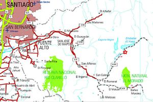
From Santiago, you should take Route G-25 at Cajon del Maipo. From the Vizcachas crossing, 47 kilometers are paved in good condition to the control of police of San Gabriel (phone 8611008 and 8612290, if you want to check the status of the road, although the responses tend to be too "conservative"). Then are 1.1 miles of pavement to the confluence of the Maipo Gypsum. Immediately after the bridge starts on gravel, on a slope the river back Gypsum. 1.1 kilometers below (2.2 kms from Carabineros San Gabriel) is Romeral, with some houses and mining facilities. At this point you turn right and continue on the path G-455. There are about 18 kilometers of gravel in regular state to the dam of the reservoir the Yeso which is the maximum you can go by car. This item is a 2520 meters, so that between May and October is usually not possible reach by car.
Access by public transport and hitchhiking
Public busses to Cajón del Maipo
- Public busses (subsidized): El Alfalfal – San José de Maipo; Baños Morales (Lo Valdés) – El Volcán – San José de Maipo and El Volcán–San José de Maipo cost CLP$1200 (US$ 1.4 as of February 2026). It can cost as little as $300 for shorter distances.
- Turmaipo: From October to January first, Saturdays, Sundays and holidays. Daily in January and February. Departures at 7:30 AM and from Baños Morales at 18:000. It departures from Terminal de Metrobuses Bellavista de la Florida, platform E, or from Las Mercedes (Puente Alto) around 7:50. In San José de Maipo at about 8:35, to finally reach Baños Morales around 10:15. CLP$8000 (US$ 9.3 as of February 2026) round trip to Baños Morales, cheaper for shorter distances. Phone: +56228424208, +56222830082, +56228611518, cell +56982896718
- Buses TurMarzur: Phone +56993357800
Private vans to Cajón del Maipo
- Turismontaña: +56991219203
- Baños Morales: CLP$10000 (US$ 11.7 as of February 2026) round trip, per person, $12000 if you return a different day.
- Embalse El Yeso: CLP$10000 (US$ 11.7 as of February 2026) per person
- Turismo Arpue: CLP$10000 (US$ 11.7 as of February 2026) per person. Bookings at least 24 hours in advnace +56222117165 - +56226818475 cel: +56999320108
Both companies depart from Baquedano Metro Station (red and green lines), at the side of Telefónica building. The departure is at 7:30, to reach Baños Morales at about 10:00. That is, the foot same dam.
Given that the alternative bus permits only reach Romeral (which lies on the road to Baños Morales), from this point you should try the hitchhiking. The road traffic is low, so it is likely that the expected to be a weekend long, and too long on a weekday.
Route description
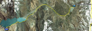
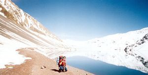
The route described here starts at the dam, although it is likely that the Snow forced to start a little lower. However, it is only immediately after snowfalls that will fail the Andean water facilities, 1400 m before the dam itself. From this point you should begin to move eastward to the vehicle along the road surrounding the reservoir for its southern shore. Are some 6.7 kilometers along the coast. In winter, the ground is difficult because in many places the snow-laden slope falls steep slope to the reservoir, the road is cut repeatedly by residual snow boards of avalanches.
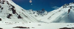
skis, you should know how to sing well in this area. Once you arrive the east end of the lake, the terrain is much easier. Continue inward toward the northeast by a low slope area, where the valley is quite wide. It will be visible from the towering pyramid somital
Rigging north . The valley gradually narrows and starts, 5.9kilometers downstream of the dam soon after a monument to Andean waters workers killed on the spot, the road turns almost 90 °, and the walk continues towards the southeast. It should be gaining 5 miles, on the north bank of the river Gypsum, on a stretch of more pending. It is an area which in summer is usually covered with grass and often inhabited by animals.
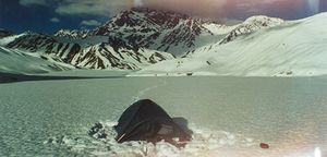
extends brought many, and appear to the south the glaciers of Marmolejo. Our route turns gradually to the north. Call go 2.9 miles to the west bank of the estuary, the point at which the road turns east to cross the river and reach the hot springs at the foot of a gorgeous warm water upwelling from mid - the rock.
Expected Time
- Trekking: In a normal pace, with snow, this trek should
take about 7 to 8 hours one way. If you do not have snowshoes, and leaves only shoes, this time may be even higher if the snow is deep and unconsolidated. A little less to return.
- Randonnée: Consider 6 to 8 hours. A little less to return.
- Mountain Bike: Between two and three hours. One hour to return.
Permits / Fees
- There is a fee of CLP 3.000 per person to get into the Parque Valle del Yeso. The gate where the fee is charged is located between the Embalse el Yeso and the hot springs. Between late may or june and late november or december, however, the road will be closed for vehicles and there will ne no one to ask for the money.
Recommendations
- The hot springs are not really hot. Only little higher Pozón reaches the temperature "of choice." In midwinter, is desirable a snow shovel to find this deep pools.
- In summer (mountain bike) is ideal to go on a weekday, in order exploit the superior Pozón better.
Waypoints in Google Earth
- Waypoints Termas del Plomo. The route is referencial only. To download the file right-click and then select "Save file as" (IE) or "Save link as" (Firefox, Chrome). By trying to open it directly, some browsers will show the raw code with the coordinates.

