![]()
Diferencia entre revisiones de «GPT07 - Laguna Dial»
(Etiquetas: Edición desde móvil, Edición vía web móvil) |
(Etiquetas: Edición desde móvil, Edición vía web móvil) |
||
| Línea 68: | Línea 68: | ||
On the 6th day I was walking along Rio Gonzáles. From km 130 the section is full of forests and extremely beautiful. The fords are fun. Once the route reached the bridge (km 143.1), I decided to follow the advice of other folks and took the alterative option 7 (i.e. staying at the left bank of the river). The climb is significant for the first 6km of the optional route (about 500m in altitude) and without a proper shade. Fortunately there are multiple streams around during the climb. Once you get to about 1200m in altitude, an oak forest starts, another face of gpt07, very beautiful. At about there the trail forks into two paths. I took the option 07-B (the southeastern path of the fork) and it was a bad choice. The trail was hard to find and there were overgrown parts. After some trying I decided to turn back to the fork and continue with the north-west route. The trail there was very well marked and easy to follow. So my advice is once you reach the fork, take the path to your right. | On the 6th day I was walking along Rio Gonzáles. From km 130 the section is full of forests and extremely beautiful. The fords are fun. Once the route reached the bridge (km 143.1), I decided to follow the advice of other folks and took the alterative option 7 (i.e. staying at the left bank of the river). The climb is significant for the first 6km of the optional route (about 500m in altitude) and without a proper shade. Fortunately there are multiple streams around during the climb. Once you get to about 1200m in altitude, an oak forest starts, another face of gpt07, very beautiful. At about there the trail forks into two paths. I took the option 07-B (the southeastern path of the fork) and it was a bad choice. The trail was hard to find and there were overgrown parts. After some trying I decided to turn back to the fork and continue with the north-west route. The trail there was very well marked and easy to follow. So my advice is once you reach the fork, take the path to your right. | ||
| − | Buses from Puente Inglés to San Fabian go at 7am and 10am. San Fabian has cabanas that tend to be overbooked. Here is my advice: try to book Cabanas Nativas in advance (they are on whatsapp). If not possible, visit them and check on the day. The owner called about 4 other cabana sites for me and tried to find me a spot. He then offered me to stay with them in the last free cabana (for 12 people) for 35,000 CLP (i.e. a price of a small cabana) which was amazing. There are also two camping sites which have always a spot for a tent. The first one is located at (-36.5650377, -71.5525476) and is just next to a river. Price is 6,000 CLP per person. The second one is at (-36.5541935, -71.5406932) and is called Camping Luciernagas. The price is 15,000 per a tent slot. I liked the first camping more. In terms of resupply, La Montana supermarket has gas canisters. There is also a good supermarket on the main road (approximately -36.5579937, -71.5514614). San Fabian is overall a lovely city worth spending some time in. | + | Buses from Puente Inglés to San Fabian go at 7am and 10am. San Fabian has cabanas that tend to be overbooked. Here is my advice: try to book Cabanas Nativas in advance (they are on whatsapp). If not possible, visit them and check on the day. The owner called about 4 other cabana sites for me and tried to find me a spot. He then offered me to stay with them in the last free cabana (for 12 people) for 35,000 CLP (i.e. a price of a small cabana) which was amazing. There are also two camping sites which have always a spot for a tent. The first one is located at (-36.5650377, -71.5525476) and is just next to a river. It is called Camping Jahuel. Price is 6,000 CLP per person. The second one is at (-36.5541935, -71.5406932) and is called Camping Luciernagas. The price is 15,000 per a tent slot. I liked the first camping more. In terms of resupply, La Montana supermarket has gas canisters. There is also a good supermarket on the main road (approximately -36.5579937, -71.5514614). San Fabian is overall a lovely city worth spending some time in. |
* Dec 31 2022-Jan 5 2023/ Tomáš / SOBO + Option 07 | * Dec 31 2022-Jan 5 2023/ Tomáš / SOBO + Option 07 | ||
Revisión del 09:22 1 feb 2023


| All GPT sections (click to show) |
|---|
|
GPT Section Articles
|


Recent Alerts and Suggestions
5 days, 75 miles, 10K ft ascent, Jan 3-Jan 9, 2023 David and Erika SOBO We shortened this route by 25 km with a resupply at the restaurant in Los Alamos (past the ghost town of Los Ciprese) Great peeps there, who served us breakfast, recharged batteries, sold us enough ramen and soup to keep us going. For another 5 days. Also gave us a lift to a road above the border crossing at Laguna del Maule, avoiding an unnecessary conversation with boarder guards. It intersects OH-CC-A{07-01C} and starts at where the lake begins, also know as GPT section 2 alts Laguna Dial. This is a great at and plenty of water in Jan. Eliminated also the 500 meter climb and avoids some locked gaits and right of passage issues. Pretty straight forward from there till the end. One Pyrenes puppy trailed us after passing a Puesto. Owners said the puppy didn’t come back. If that happens again, they suggest to deter the puppy from following by using a stick. We found that the settlers at the first water source after the English bridge (marked Water, Settlement {07} [150.6/834]-36.61455, -71.2763) is a delightful family who offered us refuge, a lift in the morning to San Carlos, and lively entertainment.
- 28/02 a 6/03/2022 Carlos Regular Route NoBo
There is now a locked gate to acces the dirt road from/to Road 115 CH at the power station building. I was told it wasn't allowed to enter and was asked how I had got in (going Northbound it was the end of my hike). I explained I was coming from Carrizales on a trail and they opened the gate for me.
It was a Sunday and oddly enough the guards just happened to be crossing the gate in a pick up just at the very moment I arrived, so couldn't find out if the station is manned during the week.
As It was quite obvious they were not happy at all me being there I couldn't scout the place to find a way around but it looked quite possible to walk around the fence, either towards the slope or next to the river. Although if you want to enter (hiking Southbound) and there is a guard at the gate you might be turn around.
Season Section Log
- 2023-Jan-24-29 / SOBO / RR + Option 7/ Ondrej / El Medano - Puente Inglés / 6 days
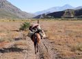
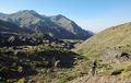
Overall, GPT07 has many different faces which I really enjoyed - alpine-like pastures, mighty rivers, an impressive laguna, and even forests for the last 25km. Most of the trail goes through long valleys. There is minimum of steep descents and ascents. However, the length and the afternoon heat still make this section challenging. Occassional fruit trees, mini-shops, arrieros, and friendly carabineros make this trail even nicer.
Details:
On the 1st day, I started hitchhiking from El Medano at 8am Tuesday, no luck after 20 min so I decided walking, hitched a car in the middle (after 6km). As I got to the fence at the trailhead, there were two cars but no one outside, so I just walked around it and all was ok. Path up the first valey was nice, there is a beautiful green plateau afterwards (what a pleasant change after gpt06!). Cows sometimes camp at the “camp” waypoints. Better not to 100% rely on the marked spots and look for other places. In general there are many good spots for camping.
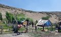
The 2nd day marked a slow descent to Carrizales, easy trail and nice views, water pastures can be avoided by following the cliffs alongside the valey. Just be careful, some rocks are unstable - I fell once and scratched myself. On a sidenote, I was quite impressed by the birds that start screaming like an old alarm clock as soon as they spot you, so every being in the valey knows you’re there. Carabineros in Carizales are the best guys ever. They served me a chilled cola and taught me how to prepare harina tostada (i also got some from them). I showed them how the satellite comm device works in return. I camped at the amazing hotsprings after Carozzales. I met two arrieros there who were just leaving. No one else showed up, so I rolled out my mat just next to the hotsprings (there is not enough space for a full tent, but a mat fits quite nicely) and spent a night there.
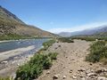
3rd to 5th days are again slow descents/ascents through valleys. Fords are very easy at this time, not above knees. Cheese from Irma is great (10k CLP per kilo) but pack it at least in two ziplock bags otherwise you’ll have the excess liquid all in your backpack like I had. Irma also had beer, cookies, chips and tuna. Laguna Dial is beautiful but indeed no shade. I camped in the middle at one of the camping spots on the shore.
On the 6th day I was walking along Rio Gonzáles. From km 130 the section is full of forests and extremely beautiful. The fords are fun. Once the route reached the bridge (km 143.1), I decided to follow the advice of other folks and took the alterative option 7 (i.e. staying at the left bank of the river). The climb is significant for the first 6km of the optional route (about 500m in altitude) and without a proper shade. Fortunately there are multiple streams around during the climb. Once you get to about 1200m in altitude, an oak forest starts, another face of gpt07, very beautiful. At about there the trail forks into two paths. I took the option 07-B (the southeastern path of the fork) and it was a bad choice. The trail was hard to find and there were overgrown parts. After some trying I decided to turn back to the fork and continue with the north-west route. The trail there was very well marked and easy to follow. So my advice is once you reach the fork, take the path to your right.
Buses from Puente Inglés to San Fabian go at 7am and 10am. San Fabian has cabanas that tend to be overbooked. Here is my advice: try to book Cabanas Nativas in advance (they are on whatsapp). If not possible, visit them and check on the day. The owner called about 4 other cabana sites for me and tried to find me a spot. He then offered me to stay with them in the last free cabana (for 12 people) for 35,000 CLP (i.e. a price of a small cabana) which was amazing. There are also two camping sites which have always a spot for a tent. The first one is located at (-36.5650377, -71.5525476) and is just next to a river. It is called Camping Jahuel. Price is 6,000 CLP per person. The second one is at (-36.5541935, -71.5406932) and is called Camping Luciernagas. The price is 15,000 per a tent slot. I liked the first camping more. In terms of resupply, La Montana supermarket has gas canisters. There is also a good supermarket on the main road (approximately -36.5579937, -71.5514614). San Fabian is overall a lovely city worth spending some time in.
- Dec 31 2022-Jan 5 2023/ Tomáš / SOBO + Option 07
This has so far going SOBO been the easiest but also the worst part. Apart from the last 45 km amd a few spots, there is a lot of road walking and the long flat valleys are not much spectacular. I wonder how the alternatives compare. Laguna del Dial is not that attractive, there are no trees around. What is good are fruit trees, from the shop in the middle of nowhere there are plume-like trees that probably ripen in late January, at the Laguna there are probably edible bushes of wild currant (probably ripe in January) and at the end at the penultimate bridge, there are lots of cherries at a puesto and then 1 km further in a former puesto - these ripen in December.
By this time of the year, all the fords were easy, not above my knees.
I ressuplied in Talca, where I got using two cars, it took me about five drivers and about 4 hours to go to the place where GPT branches off the main road. I missed the hot springs in El Medano. The trackfiles want to you to keep walking far to the West of the hut in the fenced compound, but there is a trail close to the fence that can be followed to the minor road behind. There is no cell phone coverage on the major road after the hot springs.
The first pass is nice, soon after there are lot of puestos and this was the first section where I actually met people-arrieros every day. The descent to the valley is uneventful, once you reach Rio Saso, there is a minor road with very little cars. Carabinieros took my details, asked where I went, I said Laguna del Dial and that was that. There was nobody at the shop (and they have very little supply from what I could see from the window) around 1830. They seemed to have wifi in case somebody badly needs it, it is password protected but you could ask. A few km before the hot springs, a trail branches off the main road - then it is about 10 km of trail before you reach the road again. This stretch and a few km around the shop are quite nice deapite the road).
The hot springs are nice, perfect temperature. Right next to them, there is place for a single person for sleeping otherwise you need to camp further downstream or at the camp waypoint. They can easily be reached in two days, the trail is easy. I managed without really wanting to miss the second carabinieros befora the Laguna. The roads only ends less then 10 km from the Laguna.
The first waypoint "hot springs?" is in the middle of the river, not sure what itnisnsupposed to mean.
The section feom the second pass (the one after the laguna) is really nice, first woth some trees, at the end with lots of trees.
The second "hot spring?" waypoint is real you need to ford through the canyon a bit (which is fun on its own, there are places where you can leave the canyon abiut 200 m downstream from the hot.spring) to reach it. The water is too hot, it springs not much above the levlnof the river. I tried to make a pool where the water could cool down but have not finished it. I encourage you to build upon it.
Then there is a stretch with a lot of fording (there it is gorgeous), one last ford is missing from the waypoints- you need to ford about 20 m along a steep rock fa e that falls dire,tly to the river. Do not try to go around it.
Once you reach the last bridge where the minornroad to the end of section begins (in the files it is mislabeled as trail), I encourage you to stay on the left bank and climb a bit on option 07. It goes through really nice oak (I think) forrest and it is a trail almost to the end of the section. I think thi Sparta is almost the nicest of all GPT 07 and I think RR should be routed through this option. The trail is in good condition. From Los Sauces ,there are not many cars (congratulations to other people havong been lucky). Luckily there are buses at 7 and 10 in themornong to San Fabian. The second bus goes back at two. I thinknon Sundays itnisnall shifted by one hour (so it leaves an hiur later) but I am not sure. There is signal from the last bridge but there is no cell cig al in Los Sauces.
- 26. - 31 Dec 2022 / Will / SOBO, El Médano - Puente Inglés
I had a tougher time than expected on this section, but overall still a good experience. My pace ended up similar to section 6, at times slower but with the occasional fast road to make up for it. I spent a lot of time trying to keep my feet dry but they always just ended up getting wet anyway, I had a bunch of blisters by the end of day two. My main advice just be to accept it and just trudge straight through the waterlogged pastures.
Meeting the arrieros/settlers along the way was one of the highlights. No one seemed to mind me passing through their country. Most of the time we'd just wave, and sometimes they'd call out and chat for a bit. They had some amazing yells. There was no one at the shop in Carrizales when I passed through at 4:30, but I did manage to get a fanta and some great goat cheese later from Irma. The cheese lasted well through a day and a half of hiking in the heat. 500g was the least she'd sell, so I just ate a bunch of it with chips for my last few meals.
Everyone I passed told me about another pair of hikers doing the same route, but a day ahead of me. I never caught up with them, but I know their footprints well.
The horseflies were really swarming on some stretches, they made a few nights and lunch breaks pretty uncomfortable. But I found that if I just kept walking I'd normally find a bug free spot within an hour or so. I never figured out how to predict where I'd find them. There were generally more at lower altitude and sheltered places, with lots of exceptions.
The fords were all easy for me, the highest came up to my thighs (I'm 5'11/180cm).
I spent the first night at El Médano. They didn't have a midday bus from Talca, the earliest I could go was at 3pm. The vapores were great, but a little hard to find. Pretty much empty at 6pm. The next morning I hitched easily to the start. I decided to start hiking on the other side of the river where I got dropped off, and then ford further down after the building.
I luckily caught a ride from some carabineros pretty early along the road walk at the end, who took me straight to San Fabián.
Overall a great hike. Doing it in five walking days was reasonable, but felt a bit rushed for me. The second half was definitely more enjoyable for me. If I could go back in time I'd probably hitch a bit further to the Laguna del Maule and do one of the options starting from there.
- 17. - 23. Dec 2022 / Anna & Christopher / SOBO, El Médano - Puente Inglés
We started by hitchhiking to the beginning of the dirtroad (11 km from El Médano). At about 7:30 am on a saturday we got a ride within a minute :) As Veronica wrote there is a closed gate, but you can walk around it. We met a local living there and he greeted us niceley, so it seems to be no problem. The next day we arrived in Carrizales around 4 pm. We resupplied there (the shop has a modest selection). The almacén is basically at the owners house, so one can propably buy sth there pretty late or early in the day. Plus the owner is super nice. She even offered us some fruits and vegetables for free and allowed us to camp opposite her house.
The first river crossing was the hardest for us. Anna is 1,63 m and the water reached above her hips. The other two rivers were pretty easy to cross.
From Puente Inglés we hitchhiked to San Fabián. There is also a bus once a day which leaves at 10 am.
Section 7 is really nice with beautiful views and a very diverse landscape. It gets really got in the afternoon though.
- 7 to 12 of December 2022 / Véronica / GPT07 RR SOBO / 5.5 days
Route: El Médano - Carrizales - Río Guaiquivillo - Laguna Dial - Río González - Puente Inglés
A wonderful stretch of the GPT, I especially enjoyed the second half of it. Decent trails, except when they go into cow pastures or traverse some sandy/scree cliffs where erosion has taken place. Lots of great swimming opportunities, which is good because the midday/afternoon heat gets quite oppresive.
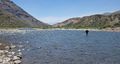
Some demanding river fords this time of year. The ones that stand out as being particularly difficult are 1: the one after the first pass after Carrizales, 2: Río Guaiquivillo (downright scary), 3: Río Paralelo before Laguna Dial (although not so bad after experiencing Guaiquivillo)
Took the bus from Talca back to El Médano at 3 pm. The "vapores" at El Médano are awesome, and free if you stay at the nearby campground. When I went three next morning at 9 a.m. there was nobody there and I got to try out and enjoy the three different saunas.
Hitching the 11km along the paved road is pretty easy, but few cars go by. There was no one at the gate/fence when I arrived, easy to go around by following the river a few hundred meters.
At the last cross-country section before Carrizales, I recommend taking the northern Option D route, as the RR takes you straight into a muddy, flooded cow pasture, and the drier mountainside is covered in pesky, sharp/thorny yellow flowers which will tear through your legs. The northern route has to be better than that!
The fences before Carrizales start near the junction where Option H ends, but I found lots of accessible water sources and decent campsites even along the fenced section. The best one was less than a km after the last "settler" waypoint before Carrizales, with lots of shade, grass, and mature trees to the right of the trail.
The hot springs after Carrizales are definitely worth the detour! They are properly hot, and right next to a beautiful, cool creek.
I'm 165 cm and Río Guaiquivillo was one of, if not the most, demanding ford I've ever done. I went upstream a couple hundred meters from where the RR crosses it, where the river braids into two channels and is wider. The current was fast in the first channel, making little rapids over the rocks, but the water only went midway up my thighs. The second channel the water went up to my hips and nearly swept me downstream. Maybe look for a better place downstream to cross the second channel once you reach the island after the first channel.
After the river crossing, follow the 4×4 path, not necessarily the GPS RR track. The GPS will try to lead you into knee-deep boggy pastures, but if you follow the 4×4 trail it should (mostly) stay dry.
The carabineros at the police puesto took down my passport info and asked when I'd be returning from Laguna Dial. I explained I was continuing onward to Puente Inglés and wouldn't be coming back.
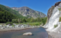
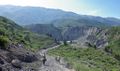
Between the police puesto and Río Los Sauces, I only saw 2 people (arrieros), and not a soul at Laguna Dial. Must be a quieter time of year. Laguna Dial is amazing - clear, cold, deep waters perfect for swimming. The trail from the west end of Laguna Dial all the way to the last bridge before Puente Inglés is awesome - clear and easy to follow. The stretch along Río González was probably my favorite part, as you are in frequent forests going along a steep-walled canyon. Plus the fords along that river were not difficult :)
I got offered a ride once I was midway through the hot, dusty road walk to Puente Inglés, and they took me straight through to San Fabian. So I can't comment on the bus schedule.
- 2022-02-06 / Molly and Melissa / RR northbound / 8 days
Generally an easy trail, but tough due to the heat and the heavy pack. Plenty of water despite the dry landscape. Not many panoramic views - instead the attraction consists of meeting the many arrieros and walking through the land where they live. We arrived by bus at El Inglés at 3:30 pm and started walking down the very hot, dry gravel road. Lots of places along the river seems great for camping/swimming. After walking a little, a car offered us a ride and dropped us off right before the first bridge. We wanted to camp at the first "hot spring?" waypoint, but there seemed to be no hot springs. From there, a nice path all the way to Laguna Dial. We ended up camping at the second camp waypoint, very nice place for a swim - which was very needed after a very hot day. The first camp waypoint has a puesto as well. We passed the police, they were very excited to have visitors and served us soda and biscuits. We camped at the next ford near a big willow. There is a campsite that seems to be used by the arrieros, but not while we were there. Irma's daughter sold us some of their cheese. They had goat and cow cheese, 1.5 L colas, beer, wine and sopaipillas. Irma wasn't home. Initially we were chased off by a pretty scary dog, but we were able to approach once some horseback riders appeared and people in the puesto came out and could shout at the dogs. After her puesto, we had some trouble finding the right path - the route kept leading off the gravel road with no path in sight. In the end, we just followed the gravel road, returning to the regular route just before the climb at the second "hot springs?" waypoint. This required a river crossing that was a little difficult even in this dry year. Pretty easy walk the rest of the way to Carrizales on a gravel road. We found many delicious brambles along the road.
- The shop in Carrizales had pasta, canned tuna, cakes, many different biscuits, popsicles, chips, bread, sodas, marmelade, harina tostada, batteries, caramels. The town itself consisted of a few houses and an avanzada de carabineros. As mentioned, some fences after the town. We camped at the next "ford" waypoint, on a nice meadow next to the river.
On the next cross country section, better stick to the route along the mountain side - the whole valley is very wet, and there's often a path to follow along the route. Many animals and puestos all the way up the mountain. We camped at the camp/ford waypoint after reaching the last gravel road. A lot of garbage, but we found a nice little place and even caught a trout. The main road is pretty big, probably easy to hitch, but goes through some pretty mountains as well.
- Termas el Medano is a nice place as well, there is a big hot pool (with some cold currents in-between) and some smaller lukewarm ones, and you can swim in the river. The entrance is 1000 pesos, but if you camp at the nearby campground (3000 pesos per person), acces is free. There is also a minishop with sodas, chocolate, chips, sunscreen and a few other things, and a restaurant with typical Chilean food. The bus leaves for Talca at 7:10 in front of the parking lot, but you have to call in advance as it only goes that far if they know someone is going - +56994741961.
- 2022-01-17 to 2022-01-24 | Veronika & Jo | GPT07 RR SOBO
Termas El Médano -> Carrizales (2 days) -> Rio Maule -> Laguna del Dial -> El Inglés (3 days)
Greatly enjoyed this section, which took us seven proper hiking days to complete.
We started at 19:00 at Termas El Médano because the only bus at Talca left at 15:00. Hiked the 11 km of tarmac and camped on the river bank next to 115, about 1 km beyond section 1 (S 35° 52.736', W 070° 40.119', courtesy of iOverlander).
At the end of the third section (around S 35° 57.665', W 070° 38.836') we could not find the path on the northern scree and rock slopes. Instead, we switched to the southern valley flank about a hundred meters before the actual switch, fording the small stream easily and following cow trails until we were back on the path. Found a decent camp site (S 35° 52.736', W 070° 40.119') after the first puesto on the mountain plains.
From about 10 km before Carrizales, all water and accompanying meadows are fenced in. If you plan to camp before Carrizales, turn back the moment you see fences appear on the side of the road. At the end of a long day, we asked the shop owner in Carrizales if she knew a good spot, and she let us camp on one of their fields (with accompanying barking dogs ;). Still, muchas gracias!
The hot springs after Carrizales were the best so far and definitely worth the detour. Señora Irma sold us fresh cheese, tomatoes, bread and coke, even though we happened upon her puesto in the middle of celebrating January 20th - either in the honor of San Sebastian or a victory in the war between Chile and Peru-Bolivia - with friends and family. Thanks again!
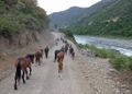
Laguna del Dial was gorgeous and great to swim in. We camped right at the start of the lake (S 36° 25.533', W 070° 55.101') where the water had sufficiently retreated to leave room for one tent. After the lake, we had the impression of taking an arriero highway, encountering plenty of horseback riders, most of them arrieros. For us, it was often hard to understand their dialect, given that we're very novice Spanish speakers. Still, got to see a glimpse of the way these modern day cowboys live.
The first bridge you encounter (sobo, around S 36° 33.547', W 071° 10.798') is rickety and unusable. Hence the second smaller bridge a bit further upstream, which I only found out about after fording the river :D
The bus at El Inglés to San Fabián left at 7:00 and 10:00 in the morning. At the bridge, the river bank opposite to the shop has some smaller streams pouring into the river, making this the relatively nicer side to camp (though there's plenty of garbage on both sides, despite the signs requesting not to litter). Some Chilean campers showed us the streams, thanks once again!
In San Fabián, stayed at Cabañas Anfer Domos for 35.000 CLP per night for two. Cabañas Nativas and Hostal El Molino were both full.
- Start Date: December 30, 2019
- Section: GPT 07 Southbound
- Duration: 6 Days
- Name/Alias: Ian Hikes + Tobias
- Overview: Just want to say quick that the termas vapaors in Mèdano are worth checking out, I highly recommend them. Please consider checking them out, they are only ½ km off the trail and absolutely worth it. They are sauna boxes built around a few hot rocks emitting hot steam. The result is a steam room/ sauna experience. I personally spend over 4 hours chilling out in the steam rooms.
- After a 2-hour road walk on the side of the highway you make your way back on trial. This section takes you thru many areas used for grazing livestock with puestos in sight almost all the time. Carizales a small settlement right on trail has a small store and the family also sells bread. There was also a puesto that sold us fresh goat cheese and Coca Cola. It is marked as a waypoint on the GPX file about 20km south of Carizales. Much of the trail is very dry and exposed and the landscape is void of trees and vegetation. There are many great places to jump into the river and cool off. The section up and around the lake offers great views of the mountains, volcanoes nearby and Laguna Dial. The trail itself is well established and never had any real trouble navigation. There were also quite a few hot springs on trail or close by.
- Difficulties: Hot and Exposed (especially in summertime). Resupply Distance.
- Highlights: Hot springs. Great sweeping views. Pools of cool water to jump into in the middle of the day.
- Please feel free to reach out and ask me any questions at Ultratrailca@gmail.com
- 2020-Jan-17/ Bruno and Martin / Regular Route Southbound
7.5 days for this great section. We resupplied in el Médano and continued with the section. Just enough variety. Highly recomend eating harina tostada, a vital meal for the arrieros, nutritious and practical. Be minded tha in our camping ground in El Médano there were only three hours of electricity a day, may be hard to recharge. Regular trail was easy to follow, except on mountain pastures where is also likely to get your feet wet. Bought some food in Carrizales. Passed through the welcoming puesto of señora Irma for some eggs, bread and cheese. Irma te manda saludos Jan! Laguna Dial is amazing and we stayed one day fishing, resting and swiming in Lake Camp -2. We were invited for some mate and tortas by a local arriero.The Rio Gonzalez valley is a complete change of scenery, with forests which we enjoyed very much. Resupplying in San Fabián.
After talking with the carabineros in San Fabián, we were told that we would not be allowed to pass through the RR near Volcán Chillán, in the last comisaria in El Roble, due to current volcanic risk. Trying instead an optional start further south, in Termas de Chillán. Maybe for next hikers it would be ok, but better to ask anyway.
- 2020-Jan-3 / Maddie & Tom / Regular Route Southbound
5 days. Starting at El Medano, hiking the regular route southbound towards El Ingles. 11km in we encountered a gate to get onto the trail with private property signs. However no one was there so we walked in without difficulty by walking around the fence (it was late Christmas Day however so it could have been quiter than normal). In general a nice route however when the track descends into cow pastures it gets very boggy and the track sometimes disappears. We did not think there were any dangerous spots. To resupply at the end of the section we took a bus in the morning from Los Sauces (10am) to San Fabian. We caught the same bus back at 1pm. Great selection of cheap food in the local ‘mountain’ supermarket and overall a good town for resupply options. It had methylated spirits for cooking but the bottle did not state the concentration. I suspect around 70%.
- 2019- Dec - 29/ Tyler & America / Optional start at Cruze de Melao then RR Sobo / 8 Days
We took our sweet time through this section. The optional start helped...as we were able to hitch all the way up to the RR at Carizales. (Bus from Talca @3, 2000 CP each) Hot springs near Carizales were warm & awesome. Two nice little tubs. We took our time and had a great time with all the arrieros along the way. Irma sells beer, wine, and delicious cheese. Other arrieros will welcome you in and treat you like family as well...so be sure to leave them with whatever you feel fit in return. All river crossings good, be diligent on filtering throughout this entire section. Dog at El Ingles shop bit me, so be careful with that. We camped down by the river for free. Bus leaves at 7:00 and 10:00 to San Fabian, and amazingly friendly town. We got a 1 bed Cabin at Cabanas Nativa for 30,000/N total. Pool, private bath & kitchen, ok WiFi, welcoming people. Fine town for re supply.
- 2019-Dec-18 / Lea Geibel & Kevin Moe / Optional/Exploration Route around Laguna del Maule / 4 days /
After finishing section 5 we only had 4 days left before the end of our hiking time, so we decided to do some exploring in the area instead of following the regular route of section 7. We followed the main road to the Laguna del Maule where we roughly went in a loop around the Laguna (~60km) starting at the Chilean Border Control. We checked in with the border control and informed them about our plans (that involved to not cross into Argentina but stay in Chile, just behind the Border Control). It was no problem for them, we just had to go through the Border Control again on our way back to have our backpacks checked for food. The water level of the laguna is very low and walking along the shore is mostly easy travel on sand/pumice, however, sometimes can be rather rocky and tedious. We climbed up some of the 3000 meter peaks around the Laguna (that mark the border with Argentina), each of them offering beautiful views on the area. There are several beautiful hidden lagunas higher up in glaciers that are well worth exploring. We never followed any particular route but just headed cross country to whichever place we fancied, which is very easy in the open, sandy terrain. The Southern end of the Laguna has many flamingos living in it, the East shore is mostly untouched by humans and the east side has some puestos and fishermen (mostly on weekends and close to the roads) but we didn't see anyone around. Around the Laguna there is a very strong thermal wind that picks up during the day but dies down/weakens a lot during the nights. Highlights: all the views, swimming in laguna, lava fields flowing into the laguna, flamingos, numerous obsidian fields, empanadas de queso at the bistro right next to the border control (only open on weekends)
- 2019-Dec-24 / Martina & Ivo / Regular Route Southbound
7 days for this awesome section. Absolutely agree with all of Matus & Anna's remarks :-) We went to San Fabian (excellent resupply place) for some days off.
- 2019-Dec-24 / Matus & Anna / Regular route SOBO
This section took us 5 days. Trail was in good conditon. River crossings were not a problem but plenty of water everywhere. In tienda in Carizales you can buy pasta, tuna, cola, beer some cookies. We bought huge chunk of cheese and some bread from Irma. It was amazing. Tienda in El Ingles is not best for resupply. We saw some tunas and pasta, but it was not enough for us to buy for next section. There is one more tienda down the road in Los Sauces but it was closed with no one around. We took bus to San Carlos which is leaving at 7am. We didn't find accomodation in El Ingles but it's possible to camp just before the bridge on the right side of the road.
07/02/20 - Arnaud - Gpt section 7 6 days, North to South Great section, easy to walk, nice people met on the way. After 11km, we leave the road with a minor road in a private property (zona geotermica). After discussion with the guard, he let us pass by the rio, and not by the porton (to join the road 400m further) because the access on the road is prohibited... ;-) Then the uphill is easy until the top. Possible resupply in Carizales with elia, whose welcome with half a sandia was perfect (pasta, atun, frutas y verduras, harina tostada but no gas). Laguna del Dial is great to have some rest. Don't hesitate to plan to spend some time there. It seems to be a good spot to fish. With the state of the volcan chillan, we decided to skip the section 8 and have some rest in San Fabian. From los Sauces to San Fabian, the micro leaves at 11pm only. We stayed by the Anfer Domos of Edgardo Lopez (+56 9 630 91 627), which is a great place to have some rest (a little far from the centre (1km), but he lends bikes if necessary), cabañas Nativa were full.
- 12 Jan 2020 Frank RR Southbound. 5 long days from KM11.
No access problem as you leave main road @ KM11, just go left around the fenced area & you will find a small track that leads up to the dirt road. Termas El Medano is last stop for bus but you can hitch first 11K. Don't expect much from shop in Carizales, contents listed by Matus are all she has. Irma, about a 1 day walk beyond Carizales has cheese, drinks in 2L bottles & sometimes bread. At Puesto 9 before Puesto Irma, fresh cold water comes up from the ground into a small pool, safe to drink without filtering. There is an arreiro living there so talk to him first. Very hot in Guaiquivilo Valley & as you go round Laguna Dial. Little shade in the valley & virtually none @ Laguna Dial. Spectacular trail down canyon on last day. You cross the river 8 times. Dogs @ Puente Ingles shop attacked me & if I didn't have a stick would have been bitten also. Camped down by Puente Ingles bridge but it's noisy on weekends & lots of horseflies. 2 buses out from Puente Ingles around 7 & 7:50AM
Summary Table
| GPT07: Laguna Dial | Hiking | Packrafting | |||||
| Group | B: Zona Arrieros | Total | 155.5 km | 49 h | 153.3 km | 47 h | |
| Region | Chile: Maule (VII) & Bío Bío (VIII) | Trails (TL) | 126.9 km | 81.6% | 115.4 km | 75.3% | |
| Start | La Mina (Termas del Médano) | Minor Roads (MR) | 5.4 km | 3.5% | 5.4 km | 3.5% | |
| Finish | Puente Ingles | Primary Roads (PR) | 11.3 km | 7.3% | 11.3 km | 7.4% | |
| Status | Published & Verified | Cross-Country (CC) | 11.9 km | 7.7% | 12.2 km | 8.0% | |
| Traversable | Jan - Mar (Maybe: Dec, Apr) | Bush-Bashing (BB) | - | - | - | - | |
| Packraft | Deployable | Ferry (FY) | - | - | - | - | |
| Connects to | GPT06, GPT08 | Investigation (I) | - | - | - | - | |
| Options | 714 km (8 Options & Variants) | Exploration (EXP) | - | - | - | - | |
| Hiking | Packrafting | Total on Water | 9.0 km | 5.9% | |||
| Attraction | 4 (of 5) | 4 (of 5) | River (RI) | - | - | ||
| Difficulty | 3 (of 5) | 3 (of 5) | Lake (LK) | 9.0 km | 5.9% | ||
| Direction | Both ↓↑ | Both ↓↑ | Fjord (FJ) | - | - | ||
| Comment | - | ||||||
| Character | Forest, Alpine Terrain, Hot Springs, Mountain Pastures, Arrieros | ||||||
| Challenges | Demanding River Fords, Exposure to Elements, Resupply Distance | ||||||
Satellite Image Map
Elevation Profile

Section Planning Status
Recommended Travel Period
Benefits of Hiking and Packrafting
Recommended Travel Direction
Section Length and Travel Duration
Suitable Section Combinations
Section Attractiveness
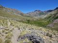
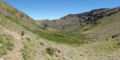
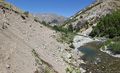
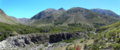
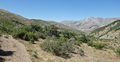
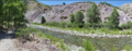
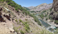
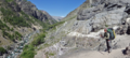
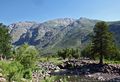
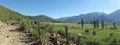
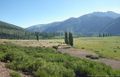
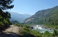
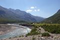
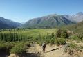
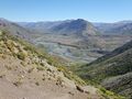
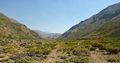
This section of the Greater Patagonian Trail leads in four to five hiking days through the wide open valley Melado to the crystal clear Laguna Dial. This lake was formed by a volcanic eruption that plugged the upper valley and transformed this part of the river into a long lake.
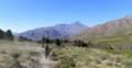
With the melting snow in spring and early summer herdsmen migrate up the valley with their animals. Occasional lush green patches intermingle with vegetation that struggles with the dry soil. But the now visible life and the accompanying river Melado make a refreshing change after having crossed the death beauty of volcanic ash and lava in the week before on section 6. Don’t miss the puesto of Señora Irma, where you can eat fresh goat cheese with bread that was recently baked in the hot ash of a fire.
After having passed the deep blue Laguna Dial you descend through the now tighter but equally scenic valleys of the rivers Rió Rodriguez and Los Sauces to the small settlement Pichi Rincon and a place called El Ingles. Here you can take a bus to the small town San Fabian to take a rest and to resupply.
Section Difficulty
Resupply
Resupply Town
- El Médano
Termas el Medano is a nice place as well, there is a big hot pool (with some cold currents in-between) and some smaller lukewarm ones, and you can swim in the river. The entrance is 1000 pesos, but if you camp at the nearby campground (3000 pesos per person), acces is free. There is also a minishop with sodas, chocolate, chips, sunscreen and a few other things - maybe some bread and flour, but nothing else for resupplying. There's also a restaurant with typical Chilean food, it was very busy when we were there but they do take away as well. The bus leaves for Talca at 7:10 in front of the parking lot, but you have to call in advance as it only goes that far if they know someone is going - +56994741961 - many others went when we were there, though.
Shopping: Food
Shopping: Fuel
Shopping: Equipment
Services: Restaurants
Services: Laundry
Services: ATM and Money Exchange
Accommodation: Hostals and Hotels
Accommodation: Cabañas
Accommodation: Camping
Transport: Ground Transport
Transport: Ferries
Transport: Shipping Services
Resupply on the Trail
Location, Names, Available Items and Services
Access to Route and Return
Access to Start
- Bus Talca - Termas El Medano
07:00, 12:30,15:00, 18:45
from Terminal Talca
- Bus Termas el Médano - Talca
The bus leaves for Talca at 7:10 am at the bus shed in front of the parking lot, but you have to call in advance as it only goes that far if they know someone is going - +56994741961. Otherwise it leaves from La Mina at 7 am
Return from Finish
Bus from Puente Ingles around 7 & 10AM. Confirm times @ the shop. Bus back from San Fabián at 2 and 6 pm
Escape Options
Permits, Entry Fees and Right-of-Way Issues
Regular Route
Regular Hiking Route
Regular Packrafting Route
Optional Routes
Investigations and Explorations
Links to other Resources
Alerts and Logs of Past Seasons
Images
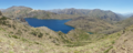
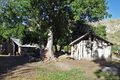
Laguna Dial
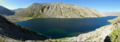
Laguna Dial