![]()
Diferencia entre revisiones de «ENG:Punta Curiñanco»
(Página creada con «{{RutaForm2_english |Actividad=Trekking |País=Chile |CiudadesChile=Valdivia |BellezaEscenica=Atractiva |Atractivos=Vistas panorámicas, Flora atractiva, Fauna atractiva, F...») |
|||
| Línea 30: | Línea 30: | ||
[[Archivo:Copihue_Curinanco.jpeg|thumb|Copihue (Lapageria rosea)]] | [[Archivo:Copihue_Curinanco.jpeg|thumb|Copihue (Lapageria rosea)]] | ||
[[Archivo:Bosque Olivillo.jpeg|thumb|Bosque de Olivillo (Aextoxicon punctatum)]] | [[Archivo:Bosque Olivillo.jpeg|thumb|Bosque de Olivillo (Aextoxicon punctatum)]] | ||
| − | == | + | ==General description== |
| − | + | The Coastal Area of Punta Curiñanco is located in the « Los Rios » region. The distance between Curiñanco and Valdivia is about 45 kilometres and 20 kilometres with Niebla city. | |
| + | Punta Curiñanco was created by CODEFF (The National Defence Committee of Fauna and Flora) in an effort to preserve the location. Since 2000 CODEFF is trying to preserve its biodiversity, to promote investigation and ecotourism but also to contribute to the social and sustainable development of this particular area. | ||
| − | + | This natural reserve of 80 hectares is composed of four easy trekking paths. | |
| + | By walking through the 10 kilometres route, you will enjoy seeing several types of local flora like: Chilean Bellflower (Copihues), Olivillos, Arrayanes fragrant flowers, Canelos, Lingues, Melis and also Murtas. | ||
| + | Punta Curiñanco provides four coastal overlooks where it’s possible to glimpse Marine Otters (Chungungo), Chilean Seasides Cinclodes, Imperial Cormorants, Red-legged Cormorants, Neotropic Cormorants an even Southern Elephant Seal. In the intern zone you could gaze Southern Pudu, Chucao Tapaculo, Kodkod, South American Grey Fox and even Magellanic Woodpeckers. | ||
| − | + | Punta Curiñanco is also really attractive thanks to its native Olivillo centenary forest, which you’ll find at the end of the trek. This special area is sacred for Mapuches because of the presence of a ceremonial place. That area has a notable spiritual atmosphere, which can be perceived by visitors. For this reason, it’s forbidden to take pictures during cultural ceremonials, in order to respect the tribal beliefs and traditions. The Olivillo’s forest is a hybrid area which mixes biodiversity conservation and immaterial legacy. | |
| − | == | + | ==Best period to go== |
| − | + | Open all year long, but it’s recommended to visit between Spring and Summer for better climatic conditions. The “Region de los Rios” is well-known for its rainy climate all year long, but more so during Autumn and Winter. | |
| − | == | + | ==Access== |
| − | === | + | ===Own vehicle=== |
| − | Punta Curiñanco | + | Punta Curiñanco is located at 40 kilometres of Valdivia City centre. The access is possible by taking the road T-350 (Valdivia/Niebla’s route) and then by road T-352 (Niebla/Curiñanco’s route) |
| − | === | + | ===Public transportation or hitchhiking=== |
| − | + | You can easily take the Valdivia/Niebla/Curiñanco bus which cost a $1.200 (in Chilean peso) for adult. It attends in Valdivia city centre bus station, departure every 1 hour. | |
| − | == | + | ==Curiñanco trekking’s description== |
| − | + | The trekking route is pretty easy to cross. You should wear the right outfit for outdoors’ activities because the region is really rainy, so the route can be slippery. Luckily the road is well maintained by Mr Rodrigo Bastidas. The signs are clear, and you also can find information about the local flora. It will be easiest for you to take the Olivillo’s path, which is less demanding in term of climbing/walking effort. | |
| − | + | In Curiñanco’s area, a large amount typical flora from the region can be identified. Ferns grow in abundance as well as bushes and trees between 3 and 5 meters such as the “Notro”, “Canelo”, “Arrayanes fragrant flowers” and “Avellanillo”. | |
| + | On the coastal side we also can see bush species like “Chaura”, “Murta”, “Ñipa Roja” and “Chupon”. Eventually at the end of the trekking road, we’ll find the “Adult Forest” composed of Olivillos of 26 metres with trunks of 80 centimetres diameters. | ||
| + | |||
| + | Punta Curiñanco’s trekking road has 3 mains coastal overlooks, where it’s possible to observe the coastal bush, the Olivillo’s forest from the outside, and of course a lot more fauna species like Marine Otters (Chungungo), Red-legged Cormorants, Southern Elephant Seal, Neotropic Cormorants and Chilean Seasides Cinclodes. | ||
| − | + | ===Time=== | |
| − | + | You can plan to spend around an hour and a half to complete the total trekking road. | |
| + | But it is recommended to do it at a lower speed in order to appreciate this area’s landscapes. | ||
| + | Walking slowly the road can be done in two hours. | ||
| − | |||
| − | == | + | ==Price== |
| − | * | + | *$2.000 in Chilean peso, roughly 3US$ for adults |
| − | *$ | + | *$1.000 for students, retired, children |
| − | + | Hours: | |
| − | * | + | *Autumn-Winter 8:30 am to 4:30 pm, during winter period the reserve will close earlier. |
| − | * | + | *Spring-Summer 8:30 am to 7:30 pm |
| − | + | Closed on celebrated days. | |
| − | == | + | |
| + | ==External links== | ||
*[http://www.codeff.cl/area-punta-curinanco/ CODEFF, Punta Curiñanco] | *[http://www.codeff.cl/area-punta-curinanco/ CODEFF, Punta Curiñanco] | ||
*[https://www.youtube.com/watch?v=ezrEnS3miEk Punta Curiñanco] | *[https://www.youtube.com/watch?v=ezrEnS3miEk Punta Curiñanco] | ||
| − | == | + | ==Recommendations== |
| + | *Forbidden to do fires and to cook inside of the reserve | ||
| + | *Forbidden to hunt animals | ||
| + | *Forbidden to remove or to hurt the vegetation | ||
| + | *Forbidden to enter the reserve with bicycles | ||
| + | *Forbidden to smoke or to drink alcohol | ||
| + | *Suggested to walk through authorized path | ||
| + | *Forbidden to persecute or to feed local species | ||
| + | *Forbidden to interfere nests or dens | ||
| + | *Being cautious in paths and watchtowers | ||
| + | *Forbidden to camp inside of the protect area | ||
| + | *Forbidden to throw out garbage or rubbish | ||
| + | *It’s highly recommended not eating inside of the reserve to avoid Hanta Virus. | ||
Revisión del 11:22 21 jun 2017
|
|
|
| |||||||||||||||||||||||||||||||||||||||||||||||||||


General description
The Coastal Area of Punta Curiñanco is located in the « Los Rios » region. The distance between Curiñanco and Valdivia is about 45 kilometres and 20 kilometres with Niebla city. Punta Curiñanco was created by CODEFF (The National Defence Committee of Fauna and Flora) in an effort to preserve the location. Since 2000 CODEFF is trying to preserve its biodiversity, to promote investigation and ecotourism but also to contribute to the social and sustainable development of this particular area.
This natural reserve of 80 hectares is composed of four easy trekking paths. By walking through the 10 kilometres route, you will enjoy seeing several types of local flora like: Chilean Bellflower (Copihues), Olivillos, Arrayanes fragrant flowers, Canelos, Lingues, Melis and also Murtas. Punta Curiñanco provides four coastal overlooks where it’s possible to glimpse Marine Otters (Chungungo), Chilean Seasides Cinclodes, Imperial Cormorants, Red-legged Cormorants, Neotropic Cormorants an even Southern Elephant Seal. In the intern zone you could gaze Southern Pudu, Chucao Tapaculo, Kodkod, South American Grey Fox and even Magellanic Woodpeckers.
Punta Curiñanco is also really attractive thanks to its native Olivillo centenary forest, which you’ll find at the end of the trek. This special area is sacred for Mapuches because of the presence of a ceremonial place. That area has a notable spiritual atmosphere, which can be perceived by visitors. For this reason, it’s forbidden to take pictures during cultural ceremonials, in order to respect the tribal beliefs and traditions. The Olivillo’s forest is a hybrid area which mixes biodiversity conservation and immaterial legacy.
Best period to go
Open all year long, but it’s recommended to visit between Spring and Summer for better climatic conditions. The “Region de los Rios” is well-known for its rainy climate all year long, but more so during Autumn and Winter.
Access
Own vehicle
Punta Curiñanco is located at 40 kilometres of Valdivia City centre. The access is possible by taking the road T-350 (Valdivia/Niebla’s route) and then by road T-352 (Niebla/Curiñanco’s route)
Public transportation or hitchhiking
You can easily take the Valdivia/Niebla/Curiñanco bus which cost a $1.200 (in Chilean peso) for adult. It attends in Valdivia city centre bus station, departure every 1 hour.
Curiñanco trekking’s description
The trekking route is pretty easy to cross. You should wear the right outfit for outdoors’ activities because the region is really rainy, so the route can be slippery. Luckily the road is well maintained by Mr Rodrigo Bastidas. The signs are clear, and you also can find information about the local flora. It will be easiest for you to take the Olivillo’s path, which is less demanding in term of climbing/walking effort.
In Curiñanco’s area, a large amount typical flora from the region can be identified. Ferns grow in abundance as well as bushes and trees between 3 and 5 meters such as the “Notro”, “Canelo”, “Arrayanes fragrant flowers” and “Avellanillo”. On the coastal side we also can see bush species like “Chaura”, “Murta”, “Ñipa Roja” and “Chupon”. Eventually at the end of the trekking road, we’ll find the “Adult Forest” composed of Olivillos of 26 metres with trunks of 80 centimetres diameters.
Punta Curiñanco’s trekking road has 3 mains coastal overlooks, where it’s possible to observe the coastal bush, the Olivillo’s forest from the outside, and of course a lot more fauna species like Marine Otters (Chungungo), Red-legged Cormorants, Southern Elephant Seal, Neotropic Cormorants and Chilean Seasides Cinclodes.
Time
You can plan to spend around an hour and a half to complete the total trekking road. But it is recommended to do it at a lower speed in order to appreciate this area’s landscapes. Walking slowly the road can be done in two hours.
Price
- $2.000 in Chilean peso, roughly 3US$ for adults
- $1.000 for students, retired, children
Hours:
- Autumn-Winter 8:30 am to 4:30 pm, during winter period the reserve will close earlier.
- Spring-Summer 8:30 am to 7:30 pm
Closed on celebrated days.
External links
Recommendations
- Forbidden to do fires and to cook inside of the reserve
- Forbidden to hunt animals
- Forbidden to remove or to hurt the vegetation
- Forbidden to enter the reserve with bicycles
- Forbidden to smoke or to drink alcohol
- Suggested to walk through authorized path
- Forbidden to persecute or to feed local species
- Forbidden to interfere nests or dens
- Being cautious in paths and watchtowers
- Forbidden to camp inside of the protect area
- Forbidden to throw out garbage or rubbish
- It’s highly recommended not eating inside of the reserve to avoid Hanta Virus.
Photo gallery
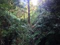
Fern forest
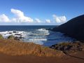
Beach

