Diferencia entre revisiones de «Cerro el Roble (ruta vehicular) (english)»
| Línea 3: | Línea 3: | ||
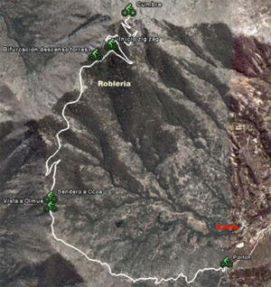
[[Imagen:Mapa ascenso Roble.jpg|thumb|300px|right|Map of the Route]] | [[Imagen:Mapa ascenso Roble.jpg|thumb|300px|right|Map of the Route]] | ||
==Season== | ==Season== | ||
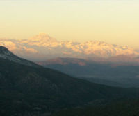
| − | This trek can be done year round, but the | + | This trek can be done year round, but the ideal time is May, when the Oak trees are red, orange, and yellow. The winter months are also good when the Andes are covered in snow, and there is a beautiful view to the Aconcagua and company. |
For those who chose to ascend by bike, you should be careful in those days that just after a front of bad weather, snow has fallen on the peak. During those days (4 or 5 days a year) it can be necessary to carry your bike on the final stretch. | For those who chose to ascend by bike, you should be careful in those days that just after a front of bad weather, snow has fallen on the peak. During those days (4 or 5 days a year) it can be necessary to carry your bike on the final stretch. | ||
| Línea 10: | Línea 10: | ||
==Route Description== | ==Route Description== | ||
| − | [[Imagen:Perfi ascenso Roble.png|thumb|200px|right| | + | [[Imagen:Perfi ascenso Roble.png|thumb|200px|right|Height Profile of the Route]] |
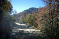
| − | + | The route begins at the gate, where you must pay for the access. The path is clear to peak, since it is a vehicle road built for the construction and maintenance of the antennas at the peak. On a normal weekend (specially after a snowfall), you should find a few cars on the road. From the access gate, start west. The road ascends without stopping up to the peak. The first stretch is through the south edge of the hill. It then reaches the edge that divides the valleys of Caleu and Olmué. Towards the west you will have beautiful views[[Imagen:Ruta_al_roble.jpg|thumb|200px|left|Ascent stretch. June, 2006]] of the Ocoa palm grove and La Campana. Briefly after this first view of the valley of Olmué, a pedestrian fork appears to the path that leads to Ocoa. For the peak of El Roble, continue up the main vehicle road. You will then pass by a wooden fence to the left. Then the road penetrates the Oak forrest, and then begins a hard zig-zag. [[Imagen:Vista_la_campana.jpg|thumb|200px|right|View of La Campana to the West. June, 2006]] Little before the peak, you will be able to see some of the transmission towers. The peak is a relatively large plain, with installations for telecommunication services that take away from the feeling of being outdoors, but the view is nevertheless beautifully impressive. | |
| − | === | + | |
| − | *'''Trekking''': 4 | + | ===Estimated Time=== |
| − | *'''Mountain Bike''': | + | *'''Trekking''': 4 hours from the gate. It is possible to continue a little more by car and reduce the walking time. |
| − | + | *'''Mountain Bike''': 2,5 hours from the gate. | |
{{Entrada al Roble}} | {{Entrada al Roble}} | ||
| − | == | + | ==Recommendations== |
| − | + | It is recommended to do the ascent stretch on the vehicle road when it has snowed in Santiago. It can be done in randonnée or rackets, low difficulty. [[Imagen:Roble_aconcagua.jpg|thumb|200px|left|Aconcagua and Mountain Range. August 11, 2007. Photo: Constanza Miranda]] | |
| − | [[Imagen:Roble_camino.jpg|thumb|200px|right| | + | [[Imagen:Roble_camino.jpg|thumb|200px|right|Vehicle road with snow. August 11, 2007. Foto:[http://www.innovacionsocial.cl Constanza Miranda] ]] |
| − | == | + | ==Route and Waypoints on Google Earth== |
*[[Media:Cerro_el_Roble.kmz|Ruta del Cerro El Roble]]. {{Descargar waypoints}} | *[[Media:Cerro_el_Roble.kmz|Ruta del Cerro El Roble]]. {{Descargar waypoints}} | ||
Revisión del 18:06 24 jun 2009

|

|
Contenido
Season
This trek can be done year round, but the ideal time is May, when the Oak trees are red, orange, and yellow. The winter months are also good when the Andes are covered in snow, and there is a beautiful view to the Aconcagua and company. For those who chose to ascend by bike, you should be careful in those days that just after a front of bad weather, snow has fallen on the peak. During those days (4 or 5 days a year) it can be necessary to carry your bike on the final stretch.
Acceso
En auto
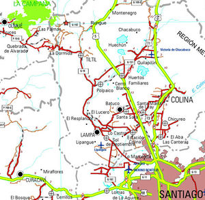
Desde Santiago, se debe tomar la carretera panamericana (ruta 5) en dirección al norte. El desvío a Rungue está en el kilómetro 54. Se debe tomar esa salida (indicada por un cartel de "RUNGUE RETORNO" porque sirve para ambas cosas) y entrar al pueblo. Donde termina la calle por la que venimos, se debe doblar a la izquierda y, pocos metros más adelante, a girar a la derecha (se acaba la calle de todos modos) para cruzar la linea ferrea y luego un puente sobre un estero. Inmediatamente después de cruzado el estero, se debe girar a la izquierda, y comenzar a bordear el estero por un camino de asfalto. Se bordeará luego el embalse Rungue. Tras 3,9 kilómetros desde la panamericana y justo después de cruzar un puente pequeño, surge un desvío a la derecha ("A Caleu"), el que se debe tomar. Este camino está pavimentado también, pero es muy angosto, por lo que se debe tener mucha precaución en las curvas. El camino se interna por el valle y asciende progresivamente. Aproximadamente en el kilómetros 11 desde el desvío (14,9 desde la panamericana) se ha llegado a Caleu y surge una bifurcación: debe tomarse la izquierda, que sigue subiendo ladera arriba. 970 metros más arriba, muy poco antes del paso hacia el valle de Olmué, se encuentra la caseta de cobro y el portón desde donde surge el camino la cumbre del cerro El Roble a mano derecha.
Nota: También es posible llegar a Caleu desde Til-Til, para lo cual se debe dejar la carretera panamericana en un desvío anterior, pero resulta más rápido la variante por Rungue descrita más arriba.
En transporte público
Existen tres recorridos únicos que van desde Tiltil a Caleu, que salen desde el supermercado Unimarc. En primer lugar se debe tomar un bus desde Santiago en el terminal la Paz, cerca del metro Cal y canto con dirección a Tiltil. Por medio de transporte publico sólo es posible asistir los sábados, dado los horarios de ingreso del Santuario. Para esto se debe tomar el bus que sale a las 10 am del supermercado Unimarc de Tiltil, estarán llegando al rededor de las 10:30 hrs a la entrada del santuario(el horario de ingreso es hasta las 12). Para regresar se puede tomar un bus que pasa a las 17:30 hrs desde Caleu a Tiltil por el mismo camino principal.
Route Description
The route begins at the gate, where you must pay for the access. The path is clear to peak, since it is a vehicle road built for the construction and maintenance of the antennas at the peak. On a normal weekend (specially after a snowfall), you should find a few cars on the road. From the access gate, start west. The road ascends without stopping up to the peak. The first stretch is through the south edge of the hill. It then reaches the edge that divides the valleys of Caleu and Olmué. Towards the west you will have beautiful views of the Ocoa palm grove and La Campana. Briefly after this first view of the valley of Olmué, a pedestrian fork appears to the path that leads to Ocoa. For the peak of El Roble, continue up the main vehicle road. You will then pass by a wooden fence to the left. Then the road penetrates the Oak forrest, and then begins a hard zig-zag. Little before the peak, you will be able to see some of the transmission towers. The peak is a relatively large plain, with installations for telecommunication services that take away from the feeling of being outdoors, but the view is nevertheless beautifully impressive.Estimated Time
- Trekking: 4 hours from the gate. It is possible to continue a little more by car and reduce the walking time.
- Mountain Bike: 2,5 hours from the gate.
Permisos / Tarifas
- Se deben cancelar CLP$4000 (US$ 4.2 as of November 2024) por adulto para ingresar (niños gratis). El ingreso es administrado por la Asociación de Comuneros Capilla de Caleu, y está abierta fines de semanas y festivos de 9 a 13 horas. En caso de ir un día hábil y querer cruzar el portón en auto, se debe llamar al celular +56984759457 o al +56962382245.
Recommendations
It is recommended to do the ascent stretch on the vehicle road when it has snowed in Santiago. It can be done in randonnée or rackets, low difficulty.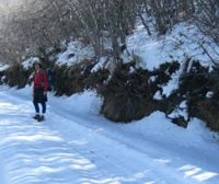
Route and Waypoints on Google Earth
- Ruta del Cerro El Roble. Para descargar el archivo se recomienda hacer click con el botón derecho del mouse y luego seleccionar "Guardar destino como" (Internet Explorer), "Guardar enlace como" (Firefox) o "Save link as" (Google Chrome). Si se intenta abrir directamente, algunos navegadores abrirán el código crudo del archivo con el listado de coordenadas.

